Property Record
1114 State Route 173, Asbury, NJ 08802
NEARBY LISTINGS FOR SALE OR LEASE
-
-
View all Asbury listings for sale on LoopNet.com
Property Detail
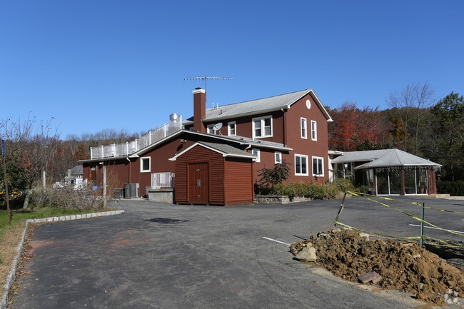
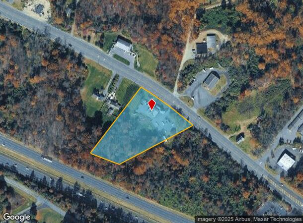
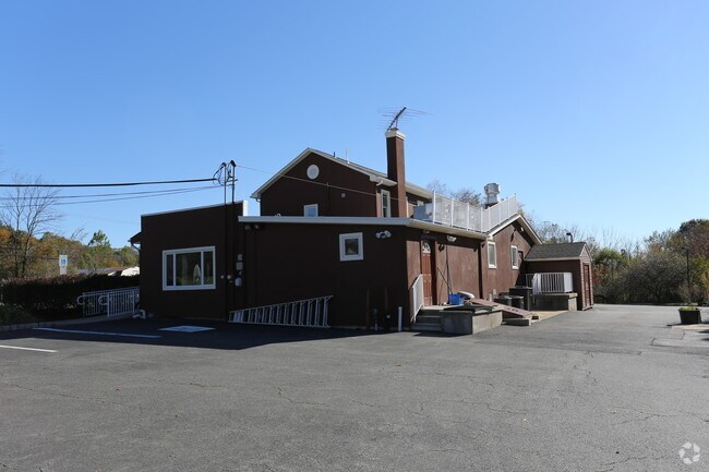
1114 State Route 173
02-00013-0000-00013
Hunterdon
Restaurantbuilding
New Jersey
X
13
34019C0094F
3.10 AC
2024
Hunterdon
2025
Northern New Jersey
010400
Newark, NJ-PA
3,324 SF
DEMOGRAPHICS near 1114 State Route 173
1 Mile
3 Mile
5 Mile
2024 Total Population
932
6,084
19,994
2029 Population
938
6,130
20,176
Pop Growth 2024-2029
+ 0.64%
+ 0.76%
+ 0.91%
Average Age
44
44
44
2024 Total Households
338
1,964
7,162
HH Growth 2024-2029
+ 0.59%
+ 1.07%
+ 1.14%
Median Household Inc
$119,152
$127,212
$116,011
Avg Household Size
2.80
2.80
2.60
2024 Avg HH Vehicles
2.00
2.00
2.00
Median Home Value
$420,548
$466,798
$418,388
Median Year Built
1970
1976
1976
Nearby Places
Map Layers
Map Styles
 Street
 Aerial
- Restaurants
- Banks
- Shops
- Fitness
- Groceries
PUBLIC TRANSPORTATION
COMMUTER RAIL
Annandale (Raritan Valley Line - NJ Transit Commuter Rail (NJ Transit))
DRIVE
WALK
Distance
Annandale (Raritan Valley Line - NJ Transit Commuter Rail (NJ Transit))
11 min
7.7 mi
High Bridge (Raritan Valley Line - NJ Transit Commuter Rail (NJ Transit))
DRIVE
WALK
Distance
High Bridge (Raritan Valley Line - NJ Transit Commuter Rail (NJ Transit))
12 min
8.4 mi
AIRPORT
Lehigh Valley International
DRIVE
WALK
Distance
Lehigh Valley International
42 min
27.5 mi
Trenton Mercer
DRIVE
WALK
Distance
Trenton Mercer
54 min
36.3 mi
Freight Ports
New York Container Terminal
DRIVE
WALK
Distance
New York Container Terminal
67 min
51.7 mi
SALE & LEASE HISTORY
LISTING DATE
SALE/LEASE

Jul 16, 2018
For Sale
Dec 04, 2017
For Sale
Nearby Properties
Address
Land Use
TOTAL SIZE
Lot Size
Zoning
Address
Land Use
TOTAL SIZE
Lot Size
Zoning
500.58 AC
WM
Address
Land Use
TOTAL SIZE
Lot Size
Zoning
2.27 AC
OR1
Address
Land Use
TOTAL SIZE
Lot Size
Zoning
3,205 SF
22.05 AC
CR
Address
Land Use
TOTAL SIZE
Lot Size
Zoning
151.92 AC
INS
Address
Land Use
TOTAL SIZE
Lot Size
Zoning
157.99 AC
INS
Address
Land Use
TOTAL SIZE
Lot Size
Zoning
2.40 AC
OR1
Address
Land Use
TOTAL SIZE
Lot Size
Zoning
1,120 SF
103 AC
INS
Address
Land Use
TOTAL SIZE
Lot Size
Zoning
12.60 AC
VR
Address
Land Use
TOTAL SIZE
Lot Size
Zoning
4,948 SF
354.37 AC
CR
Address
Land Use
TOTAL SIZE
Lot Size
Zoning
9.05 AC
MR
Address
Land Use
TOTAL SIZE
Lot Size
Zoning
71.36 AC
INS
Address
Land Use
TOTAL SIZE
Lot Size
Zoning
800 SF
28.04 AC
MR
Address
Land Use
TOTAL SIZE
Lot Size
Zoning
11.75 AC
PO
Address
Land Use
TOTAL SIZE
Lot Size
Zoning
1,392 SF
5.89 AC
PC
Address
Land Use
TOTAL SIZE
Lot Size
Zoning
185.60 AC
AR
Address
Land Use
TOTAL SIZE
Lot Size
Zoning
54.31 AC
INS
Address
Land Use
TOTAL SIZE
Lot Size
Zoning
4.19 AC
VC
Address
Land Use
TOTAL SIZE
Lot Size
Zoning
8.58 AC
PC
Address
Land Use
TOTAL SIZE
Lot Size
Zoning
5.27 AC
PO
Address
Land Use
TOTAL SIZE
Lot Size
Zoning
34,410 SF
10.01 AC
PC
Address
Land Use
TOTAL SIZE
Lot Size
Zoning
14.70 AC
MFG
Address
Land Use
TOTAL SIZE
Lot Size
Zoning
4,107 SF
10.19 AC
PC
Address
Land Use
TOTAL SIZE
Lot Size
Zoning
32.98 AC
INS
Address
Land Use
TOTAL SIZE
Lot Size
Zoning
29,456 SF
12.18 AC
VC
Address
Land Use
TOTAL SIZE
Lot Size
Zoning
0.71 AC
OR1
Address
Land Use
TOTAL SIZE
Lot Size
Zoning
5,528 SF
1.23 AC
HR
Address
Land Use
TOTAL SIZE
Lot Size
Zoning
153.13 AC
MR
Address
Land Use
TOTAL SIZE
Lot Size
Zoning
7,144 SF
6.52 AC
PC
Address
Land Use
TOTAL SIZE
Lot Size
Zoning
6.04 AC
ROM
Address
Land Use
TOTAL SIZE
Lot Size
Zoning
8,120 SF
12.07 AC
I
The World's #1 Commercial Real Estate Marketplace
Connect with us
© 2025 CoStar Group
The information above has been obtained from sources believed reliable. While we do not doubt its accuracy we have not verified it and make no guarantee, warranty or representation about it. It is your responsibility to independently confirm its accuracy and completeness. Any projections, opinions, assumptions, or estimates used are for example only and do not represent the current or future performance of the property. The value of this transaction to you depends on tax and other factors which should be evaluated by your tax, financial, and legal advisors. You and your advisors should conduct a careful, independent investigation of the property to determine to your satisfaction the suitability of the property for your needs.