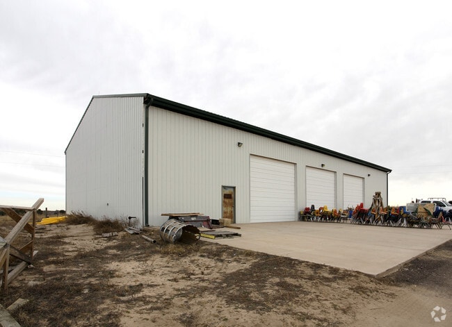
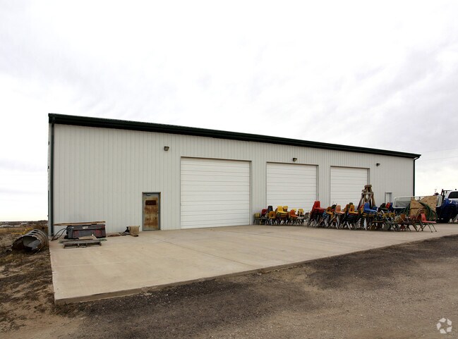
Property Record
11145 E Us Highway 24, Peyton, CO 80831

Property Detail
11145 E Us Highway 24
53130-00-050
TRACT IN N2 SEC 13-13-65 AS FOLS, BEG AT MOST WLY COR OF TR CONV BY BK 1991-306 SD COR BEING ON SELY R/W LN OF HWY 24, TH SWLY ALG SD R/W LN 500.73 FT, ANG L 90< SELY 871.2 FT, ANG L 90< NELY 500.0 FT TO MOST SLY COR OF AFMD TR, TH NWLY 871.2 FT TO P
Commercialnec
EL PASO
C-2 RR-5
Colorado
B and X Area of moderate flood hazard, usually the area between the limits of the 100-year and 500-year floods.
10.01 AC
2024
Southeast
2025
Colorado Springs
005123
Colorado Springs, CO
24,833 SF
NEARBY LISTINGS FOR SALE OR LEASE
DEMOGRAPHICS near 11145 E Us Highway 24
1 mile
3 mile
5 mile
2025 Total Population
1,183
16,855
74,793
2030 Population
1,186
17,450
77,200
Pop Growth 2025-2030
+ 0.25%
+ 3.53%
+ 3.22%
Average Age
38
36
36
2025 Total Households
406
5,535
24,718
HH Growth 2025-2030
+ 0.74%
+ 3.83%
+ 3.43%
Median Household Inc
$120,749
$122,064
$125,103
Avg Household Size
2.90
3.00
3.00
2025 Avg HH Vehicles
3.00
3.00
2.00
Median Home Value
$626,157
$562,774
$529,727
Median Year Built
2004
2010
2009
Nearby Places
Map Layers
Map Styles
 Street
 Aerial
Transit
 Traffic
 Biking
Places
Listings with unknown addresses are not visible on the map
- Restaurants
- Banks
- Shops
- Fitness
- Groceries
PUBLIC TRANSPORTATION
AIRPORT
City of Colorado Springs Municipal
Drive
Walk
Distance
City of Colorado Springs Municipal
19 min
9.8 mi
Freight Ports
Tulsa Port Of Catoosa
Drive
Walk
Distance
Tulsa Port Of Catoosa
719 min
680.2 mi
Nearby Properties
Address
Land Use
TOTAL SIZE
Lot Size
Zoning
Address
Land Use
TOTAL SIZE
Lot Size
Zoning
80,503 SF
14.36 AC
PDZ AO
Address
Land Use
TOTAL SIZE
Lot Size
Zoning
123,673 SF
9.98 AC
CR
Address
Land Use
TOTAL SIZE
Lot Size
Zoning
195,448 SF
19.86 AC
CR
Address
Land Use
TOTAL SIZE
Lot Size
Zoning
15,406 SF
5.42 AC
RR-5
Address
Land Use
TOTAL SIZE
Lot Size
Zoning
10,017 SF
1.50 AC
CR
Address
Land Use
TOTAL SIZE
Lot Size
Zoning
13,048 SF
1.63 AC
CR
Address
Land Use
TOTAL SIZE
Lot Size
Zoning
6,498 SF
4.81 AC
RR-5 CAD-O
Address
Land Use
TOTAL SIZE
Lot Size
Zoning
3,148 SF
0.58 AC
CR
Address
Land Use
TOTAL SIZE
Lot Size
Zoning
38,804 SF
39.37 AC
RR-5
Address
Land Use
TOTAL SIZE
Lot Size
Zoning
41,592 SF
8.59 AC
RR-5
Address
Land Use
TOTAL SIZE
Lot Size
Zoning
693.38 AC
PK/CR SS A
Address
Land Use
TOTAL SIZE
Lot Size
Zoning
6,289 SF
2.04 AC
CC
Address
Land Use
TOTAL SIZE
Lot Size
Zoning
299 SF
6.19 AC
PK AO SS
Address
Land Use
TOTAL SIZE
Lot Size
Zoning
8,788 SF
35.90 AC
RR-5
Address
Land Use
TOTAL SIZE
Lot Size
Zoning
8,134 SF
10.19 AC
I-2
Address
Land Use
TOTAL SIZE
Lot Size
Zoning
14,014 SF
9.90 AC
PDZ AO
Address
Land Use
TOTAL SIZE
Lot Size
Zoning
26,235 SF
2.93 AC
CR
Address
Land Use
TOTAL SIZE
Lot Size
Zoning
85,148 SF
8.12 AC
I-2
Address
Land Use
TOTAL SIZE
Lot Size
Zoning
9,901 SF
2.49 AC
CR
Address
Land Use
TOTAL SIZE
Lot Size
Zoning
22,680 SF
2.84 AC
CR
Address
Land Use
TOTAL SIZE
Lot Size
Zoning
13,954 SF
4.78 AC
RR-5
Address
Land Use
TOTAL SIZE
Lot Size
Zoning
55,980 SF
5.95 AC
CR
Address
Land Use
TOTAL SIZE
Lot Size
Zoning
625 SF
36.83 AC
MX-M AO
Address
Land Use
TOTAL SIZE
Lot Size
Zoning
160 AC
RR-5
Address
Land Use
TOTAL SIZE
Lot Size
Zoning
7.70 AC
PDZ AO
Address
Land Use
TOTAL SIZE
Lot Size
Zoning
3,866 SF
40 AC
PK
Address
Land Use
TOTAL SIZE
Lot Size
Zoning
4.77 AC
RR-5 CAD-O
Address
Land Use
TOTAL SIZE
Lot Size
Zoning
7,000 SF
4.72 AC
RR-5 CAD-O
Address
Land Use
TOTAL SIZE
Lot Size
Zoning
6,772 SF
4.32 AC
RR-5
Address
Land Use
TOTAL SIZE
Lot Size
Zoning
10,569 SF
5.07 AC
RR-5
The World's #1 Commercial Real Estate Marketplace
Connect with us
© 2026 CoStar Group
The information above has been obtained from sources believed reliable. While we do not doubt its accuracy we have not verified it and make no guarantee, warranty or representation about it. It is your responsibility to independently confirm its accuracy and completeness. Any projections, opinions, assumptions, or estimates used are for example only and do not represent the current or future performance of the property. The value of this transaction to you depends on tax and other factors which should be evaluated by your tax, financial, and legal advisors. You and your advisors should conduct a careful, independent investigation of the property to determine to your satisfaction the suitability of the property for your needs.