Property Record
1115 Boston Post Rd, West Haven, CT 06516

Property Detail
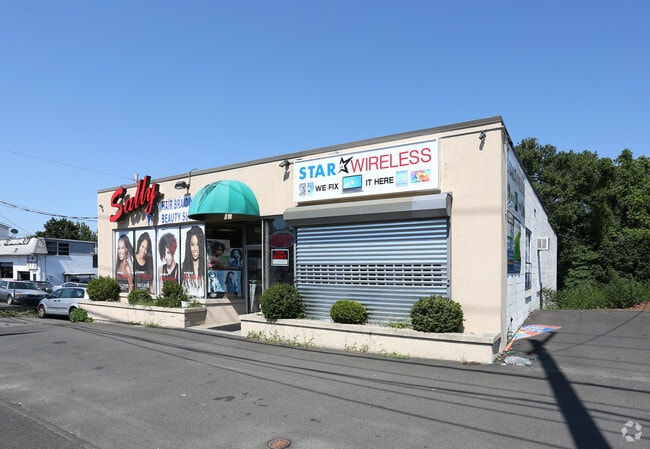
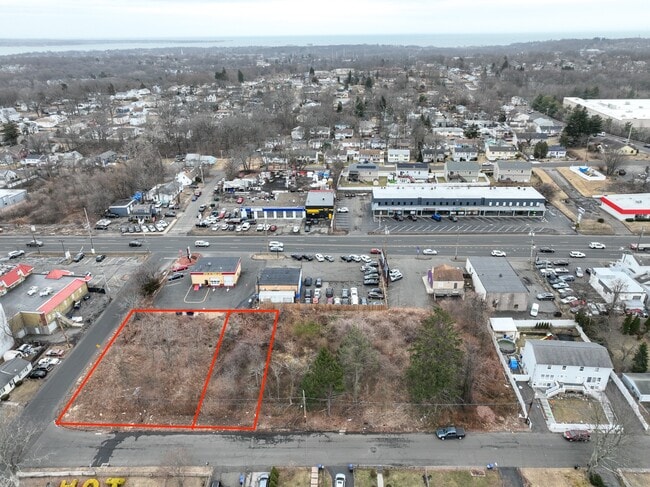
1115 Boston Post Rd
Departmentstore
South Central Ct
RB
Connecticut
B and X Area of moderate flood hazard, usually the area between the limits of the 100-year and 500-year floods.
0.18 AC
2025
West Haven
2025
Westchester/So Connecticut
154102
New Haven, CT
2,800 SF
WHAV-000046-000013
NEARBY LISTINGS FOR SALE OR LEASE
DEMOGRAPHICS near 1115 Boston Post Rd
1 mile
3 mile
5 mile
2025 Total Population
15,645
90,954
217,900
2030 Population
15,932
91,886
219,647
Pop Growth 2025-2030
+ 1.83%
+ 1.02%
+ 0.80%
Average Age
36
39
38
2025 Total Households
5,195
34,232
84,035
HH Growth 2025-2030
+ 1.83%
+ 1.01%
+ 0.87%
Median Household Inc
$66,592
$68,790
$69,781
Avg Household Size
2.50
2.40
2.30
2025 Avg HH Vehicles
2.00
2.00
1.00
Median Home Value
$266,180
$307,021
$331,341
Median Year Built
1971
1957
1957
Nearby Places
Map Layers
Map Styles
 Street
 Aerial
Layers
 Traffic
 Biking
Places
Listings with unknown addresses are not visible on the map
- Restaurants
- Banks
- Shops
- Fitness
- Groceries
PUBLIC TRANSPORTATION
COMMUTER RAIL
West Haven (New Haven - Metro-North Railroad)
Drive
Walk
Distance
West Haven (New Haven - Metro-North Railroad)
3 min
1.5 mi
New Haven (New Haven - Metro-North Railroad)
Drive
Walk
Distance
New Haven (New Haven - Metro-North Railroad)
5 min
3.4 mi
AIRPORT
Tweed/New Haven
Drive
Walk
Distance
Tweed/New Haven
15 min
8.2 mi
Freight Ports
Port of New Haven
Drive
Walk
Distance
Port of New Haven
10 min
5.3 mi
SALE & LEASE HISTORY
LISTING DATE
SALE/LEASE

May 03, 2018
For Lease
Mar 10, 2025
For Sale
Mar 10, 2025
For Sale
Feb 16, 2021
For Sale
Nearby Properties
Address
Land Use
TOTAL SIZE
Lot Size
Zoning
Address
Land Use
TOTAL SIZE
Lot Size
Zoning
289,886 SF
2.21 AC
BD2
Address
Land Use
TOTAL SIZE
Lot Size
Zoning
56,359 SF
17.09 AC
RCPD
Address
Land Use
TOTAL SIZE
Lot Size
Zoning
50.14 AC
PRD
Address
Land Use
TOTAL SIZE
Lot Size
Zoning
81,870 SF
3.86 AC
RM2
Address
Land Use
TOTAL SIZE
Lot Size
Zoning
302,262 SF
10.40 AC
RM1
Address
Land Use
TOTAL SIZE
Lot Size
Zoning
133,767 SF
1.25 AC
BD2
Address
Land Use
TOTAL SIZE
Lot Size
Zoning
72,708 SF
1.91 AC
PDU 87
Address
Land Use
TOTAL SIZE
Lot Size
Zoning
42.52 AC
PF
Address
Land Use
TOTAL SIZE
Lot Size
Zoning
287,844 SF
2.11 AC
IL
Address
Land Use
TOTAL SIZE
Lot Size
Zoning
158,622 SF
2.09 AC
BA/RM2
Address
Land Use
TOTAL SIZE
Lot Size
Zoning
29.78 AC
PRD
Address
Land Use
TOTAL SIZE
Lot Size
Zoning
76,945 SF
8.52 AC
RM2
Address
Land Use
TOTAL SIZE
Lot Size
Zoning
35.05 AC
LI-2
Address
Land Use
TOTAL SIZE
Lot Size
Zoning
840,277 SF
4.28 AC
BD2
Address
Land Use
TOTAL SIZE
Lot Size
Zoning
576 SF
RS2
Address
Land Use
TOTAL SIZE
Lot Size
Zoning
119,187 SF
1.38 AC
RO
Address
Land Use
TOTAL SIZE
Lot Size
Zoning
54,372 SF
2.42 AC
BD2
Address
Land Use
TOTAL SIZE
Lot Size
Zoning
125,676 SF
22.12 AC
BOP
Address
Land Use
TOTAL SIZE
Lot Size
Zoning
228,347 SF
0.66 AC
BA
Address
Land Use
TOTAL SIZE
Lot Size
Zoning
46,962 SF
1.48 AC
RM1/RS
Address
Land Use
TOTAL SIZE
Lot Size
Zoning
56,509 SF
1.07 AC
BA
Address
Land Use
TOTAL SIZE
Lot Size
Zoning
141,861 SF
1.62 AC
BD2
Address
Land Use
TOTAL SIZE
Lot Size
Zoning
63,304 SF
4.62 AC
RCPD
Address
Land Use
TOTAL SIZE
Lot Size
Zoning
140,931 SF
1.86 AC
RM2
Address
Land Use
TOTAL SIZE
Lot Size
Zoning
161,426 SF
4.79 AC
EFD
Address
Land Use
TOTAL SIZE
Lot Size
Zoning
93,849 SF
3.16 AC
RM1
Address
Land Use
TOTAL SIZE
Lot Size
Zoning
13,204 SF
PDD 86
Address
Land Use
TOTAL SIZE
Lot Size
Zoning
84,689 SF
0.39 AC
BA/RM2
Address
Land Use
TOTAL SIZE
Lot Size
Zoning
154,315 SF
4.29 AC
SCR
Address
Land Use
TOTAL SIZE
Lot Size
Zoning
9 AC
LI-4
The World's #1 Commercial Real Estate Marketplace
Connect with us
© 2026 CoStar Group
The information above has been obtained from sources believed reliable. While we do not doubt its accuracy we have not verified it and make no guarantee, warranty or representation about it. It is your responsibility to independently confirm its accuracy and completeness. Any projections, opinions, assumptions, or estimates used are for example only and do not represent the current or future performance of the property. The value of this transaction to you depends on tax and other factors which should be evaluated by your tax, financial, and legal advisors. You and your advisors should conduct a careful, independent investigation of the property to determine to your satisfaction the suitability of the property for your needs.