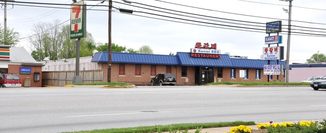
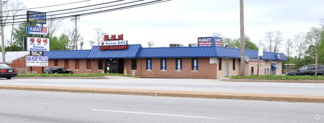
Property Record
1115 N Rolling Rd, Catonsville, MD 21228

NEARBY LISTINGS FOR SALE OR LEASE
Property Detail
1115 N Rolling Rd
01-0107150690
1.901 AC ES
Commercialacreage
Baltimore
X
Maryland
24013C0450D
1.90 AC
2024
Catonsville
2025
Baltimore
401505
Baltimore-Columbia-Towson, MD
DEMOGRAPHICS near 1115 N Rolling Rd
1 Mile
3 Mile
5 Mile
2024 Total Population
13,564
104,321
267,334
2029 Population
13,295
102,901
263,915
Pop Growth 2024-2029
(1.98%)
(1.36%)
(1.28%)
Average Age
42
40
40
2024 Total Households
4,900
39,400
101,266
HH Growth 2024-2029
(2.10%)
(1.54%)
(1.50%)
Median Household Inc
$87,773
$78,574
$72,678
Avg Household Size
2.70
2.50
2.50
2024 Avg HH Vehicles
2.00
2.00
2.00
Median Home Value
$330,797
$295,443
$287,303
Median Year Built
1966
1968
1963
Nearby Places
Map Layers
Map Styles
 Street
 Aerial
- Restaurants
- Banks
- Shops
- Fitness
- Groceries
PUBLIC TRANSPORTATION
COMMUTER RAIL
DRIVE
WALK
Distance
10 min
5.7 mi
DRIVE
WALK
Distance
10 min
5.7 mi
AIRPORT
Baltimore/Washington International Thurgood Marshall
DRIVE
WALK
Distance
Baltimore/Washington International Thurgood Marshall
18 min
10.1 mi
Ronald Reagan Washington Ntl
DRIVE
WALK
Distance
Ronald Reagan Washington Ntl
62 min
39.3 mi
Freight Ports
Port of Baltimore
DRIVE
WALK
Distance
Port of Baltimore
18 min
10.6 mi
Nearby Properties
Address
Land Use
TOTAL SIZE
Lot Size
Zoning
Address
Land Use
TOTAL SIZE
Lot Size
Zoning
1,809,709 SF
50 AC
DR3.5
Address
Land Use
TOTAL SIZE
Lot Size
Zoning
883,140 SF
57.77 AC
MLR
Address
Land Use
TOTAL SIZE
Lot Size
Zoning
608,642 SF
56.37 AC
DR3.5
Address
Land Use
TOTAL SIZE
Lot Size
Zoning
98,318 SF
175.16 AC
OT
Address
Land Use
TOTAL SIZE
Lot Size
Zoning
48,414 SF
19.18 AC
RA15
Address
Land Use
TOTAL SIZE
Lot Size
Zoning
31,590 SF
18.89 AC
RA15
Address
Land Use
TOTAL SIZE
Lot Size
Zoning
271,096 SF
6 AC
02
Address
Land Use
TOTAL SIZE
Lot Size
Zoning
278,271 SF
55.16 AC
DR5.5
Address
Land Use
TOTAL SIZE
Lot Size
Zoning
233,082 SF
10.98 AC
Address
Land Use
TOTAL SIZE
Lot Size
Zoning
36,399 SF
25.30 AC
RA15
Address
Land Use
TOTAL SIZE
Lot Size
Zoning
88,254 SF
105.20 AC
DR2
Address
Land Use
TOTAL SIZE
Lot Size
Zoning
26.14 AC
DR16
Address
Land Use
TOTAL SIZE
Lot Size
Zoning
184,320 SF
13.37 AC
DR5.5
Address
Land Use
TOTAL SIZE
Lot Size
Zoning
16.75 AC
MLR02
Address
Land Use
TOTAL SIZE
Lot Size
Zoning
48,168 SF
14.91 AC
RA15
Address
Land Use
TOTAL SIZE
Lot Size
Zoning
207,168 SF
63.84 AC
DR3.5
Address
Land Use
TOTAL SIZE
Lot Size
Zoning
16.70 AC
Address
Land Use
TOTAL SIZE
Lot Size
Zoning
29.14 AC
DR16
Address
Land Use
TOTAL SIZE
Lot Size
Zoning
312,231 SF
11.23 AC
R-5
Address
Land Use
TOTAL SIZE
Lot Size
Zoning
131,176 SF
33.97 AC
BMCT
Address
Land Use
TOTAL SIZE
Lot Size
Zoning
118,460 SF
17.85 AC
O2
Address
Land Use
TOTAL SIZE
Lot Size
Zoning
23,962 SF
17.31 AC
BRCS2
Address
Land Use
TOTAL SIZE
Lot Size
Zoning
156,834 SF
10.26 AC
DR5.5
Address
Land Use
TOTAL SIZE
Lot Size
Zoning
165,860 SF
3.35 AC
BLCCC
Address
Land Use
TOTAL SIZE
Lot Size
Zoning
23.78 AC
DR5.5
Address
Land Use
TOTAL SIZE
Lot Size
Zoning
129,423 SF
38.77 AC
DR5.5
Address
Land Use
TOTAL SIZE
Lot Size
Zoning
2,960 SF
18.72 AC
DR3.5
Address
Land Use
TOTAL SIZE
Lot Size
Zoning
117,444 SF
19.97 AC
POR
Address
Land Use
TOTAL SIZE
Lot Size
Zoning
22.99 AC
DR16
Address
Land Use
TOTAL SIZE
Lot Size
Zoning
197,754 SF
12.63 AC
DR5.5
The World's #1 Commercial Real Estate Marketplace
Connect with us
© 2026 CoStar Group
The information above has been obtained from sources believed reliable. While we do not doubt its accuracy we have not verified it and make no guarantee, warranty or representation about it. It is your responsibility to independently confirm its accuracy and completeness. Any projections, opinions, assumptions, or estimates used are for example only and do not represent the current or future performance of the property. The value of this transaction to you depends on tax and other factors which should be evaluated by your tax, financial, and legal advisors. You and your advisors should conduct a careful, independent investigation of the property to determine to your satisfaction the suitability of the property for your needs.