No Photo
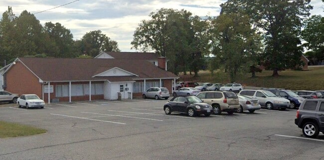
Property Record
11161 Virgil H Goode Hwy, Rocky Mount, VA 24151
NEARBY LISTINGS FOR SALE OR LEASE
-
-
View all Rocky Mount listings for sale on LoopNet.com
Property Detail
11161 Virgil H Goode Hwy
0820003700
RT 220 S
Officebuilding
Franklin
X
Virginia
51067C0335C
2.34 AC
2025
South Franklin County
2025
Roanoke
020801
Roanoke, VA
8,000 SF
DEMOGRAPHICS near 11161 Virgil H Goode Hwy
1 Mile
3 Mile
5 Mile
2024 Total Population
466
5,370
12,111
2029 Population
471
5,425
12,227
Pop Growth 2024-2029
+ 1.07%
+ 1.02%
+ 0.96%
Average Age
42
42
42
2024 Total Households
189
2,188
5,065
HH Growth 2024-2029
+ 0.53%
+ 0.82%
+ 0.71%
Median Household Inc
$64,308
$55,752
$49,054
Avg Household Size
2.40
2.30
2.30
2024 Avg HH Vehicles
2.00
2.00
2.00
Median Home Value
$180,768
$171,699
$159,719
Median Year Built
1978
1978
1978
Nearby Places
Map Layers
Map Styles
 Street
 Aerial
- Restaurants
- Banks
- Shops
- Fitness
- Groceries
PUBLIC TRANSPORTATION
AIRPORT
Roanoke/Blacksburg Regional (Woodrum Field)
DRIVE
WALK
Distance
Roanoke/Blacksburg Regional (Woodrum Field)
44 min
33.3 mi
Freight Ports
Virginia Port Authority - Richmond
DRIVE
WALK
Distance
Virginia Port Authority - Richmond
234 min
172.5 mi
SALE & LEASE HISTORY
LISTING DATE
SALE/LEASE

Sep 26, 2022
For Sale
Nearby Properties
Address
Land Use
TOTAL SIZE
Lot Size
Zoning
Address
Land Use
TOTAL SIZE
Lot Size
Zoning
203,520 SF
31.01 AC
NZ
Address
Land Use
TOTAL SIZE
Lot Size
Zoning
49,056 SF
17.03 AC
GB
Address
Land Use
TOTAL SIZE
Lot Size
Zoning
39,180 SF
4.32 AC
CBD
Address
Land Use
TOTAL SIZE
Lot Size
Zoning
34,109 SF
7.46 AC
NZ
Address
Land Use
TOTAL SIZE
Lot Size
Zoning
41,780 SF
4.50 AC
GB
Address
Land Use
TOTAL SIZE
Lot Size
Zoning
40,020 SF
3.25 AC
A1
Address
Land Use
TOTAL SIZE
Lot Size
Zoning
329,145 SF
20.77 AC
M2
Address
Land Use
TOTAL SIZE
Lot Size
Zoning
2,672 SF
37.15 AC
R1
Address
Land Use
TOTAL SIZE
Lot Size
Zoning
9,100 SF
2.95 AC
B2
Address
Land Use
TOTAL SIZE
Lot Size
Zoning
59,042 SF
6.64 AC
GB
Address
Land Use
TOTAL SIZE
Lot Size
Zoning
8,392 SF
9.80 AC
R3
Address
Land Use
TOTAL SIZE
Lot Size
Zoning
47,800 SF
4.10 AC
NZ
Address
Land Use
TOTAL SIZE
Lot Size
Zoning
2,736 SF
2.46 AC
NZ
Address
Land Use
TOTAL SIZE
Lot Size
Zoning
10,436 SF
1.34 AC
GB
Address
Land Use
TOTAL SIZE
Lot Size
Zoning
2,256 SF
106.82 AC
NZ
Address
Land Use
TOTAL SIZE
Lot Size
Zoning
13,759 SF
1.39 AC
R1
Address
Land Use
TOTAL SIZE
Lot Size
Zoning
10,624 SF
1.96 AC
CBD
Address
Land Use
TOTAL SIZE
Lot Size
Zoning
7,534 SF
5 AC
R1
Address
Land Use
TOTAL SIZE
Lot Size
Zoning
9,240 SF
3.07 AC
A1
Address
Land Use
TOTAL SIZE
Lot Size
Zoning
2,552 SF
269.84 AC
NZ
Address
Land Use
TOTAL SIZE
Lot Size
Zoning
13,780 SF
1.49 AC
CBD
Address
Land Use
TOTAL SIZE
Lot Size
Zoning
2,616 SF
76.79 AC
NZ
Address
Land Use
TOTAL SIZE
Lot Size
Zoning
10,440 SF
2.42 AC
A1
Address
Land Use
TOTAL SIZE
Lot Size
Zoning
6,276 SF
1.25 AC
CBD
Address
Land Use
TOTAL SIZE
Lot Size
Zoning
10,304 SF
8.89 AC
A1
Address
Land Use
TOTAL SIZE
Lot Size
Zoning
7,164 SF
0.47 AC
GB
Address
Land Use
TOTAL SIZE
Lot Size
Zoning
9,080 SF
4.35 AC
SM
Address
Land Use
TOTAL SIZE
Lot Size
Zoning
6.79 AC
NZ
Address
Land Use
TOTAL SIZE
Lot Size
Zoning
8,900 SF
0.53 AC
NZ
Address
Land Use
TOTAL SIZE
Lot Size
Zoning
8,105 SF
0.50 AC
NZ
The World's #1 Commercial Real Estate Marketplace
Connect with us
© 2026 CoStar Group
The information above has been obtained from sources believed reliable. While we do not doubt its accuracy we have not verified it and make no guarantee, warranty or representation about it. It is your responsibility to independently confirm its accuracy and completeness. Any projections, opinions, assumptions, or estimates used are for example only and do not represent the current or future performance of the property. The value of this transaction to you depends on tax and other factors which should be evaluated by your tax, financial, and legal advisors. You and your advisors should conduct a careful, independent investigation of the property to determine to your satisfaction the suitability of the property for your needs.