Property Record
11163 S 168Th St, Omaha, NE 68136
NEARBY LISTINGS FOR SALE OR LEASE
-
-
S 158th St. & Gold Coast Rd. - Lot 4, Steel Ridge South
Omaha, NE 68138
$6,450,000
19.60 AC Lots
Land
-
-
-
-
-
-
View all Omaha listings for sale on LoopNet.com
Property Detail
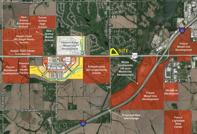
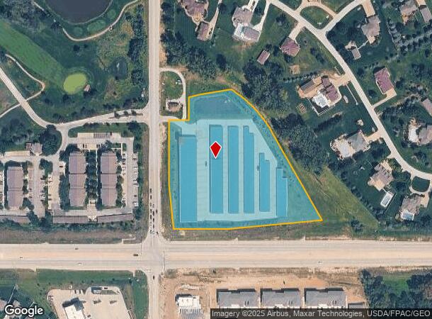
11163 S 168Th St
Omaha-Council Bluffs, NE-IA
Exc Hwy Row Lake
011290463
LOT 95 EXC HWY ROW LAKE RIDGE ESTATES (5.98 AC)
Commercialnec
Sarpy
X
Nebraska
31153C0043H
95
2024
5.98 AC
2025
Southwest Omaha
010635
Omaha/Council Bluffs
12,539 SF
DEMOGRAPHICS near 11163 S 168Th St
1 Mile
3 Mile
5 Mile
2024 Total Population
3,249
31,795
100,975
2029 Population
3,605
34,769
106,522
Pop Growth 2024-2029
+ 10.96%
+ 9.35%
+ 5.49%
Average Age
40
36
36
2024 Total Households
1,167
11,095
35,723
HH Growth 2024-2029
+ 11.31%
+ 9.49%
+ 5.52%
Median Household Inc
$142,530
$115,041
$109,877
Avg Household Size
2.80
2.80
2.80
2024 Avg HH Vehicles
2.00
2.00
2.00
Median Home Value
$398,016
$295,083
$279,013
Median Year Built
2008
2006
2000
Nearby Places
Map Layers
Map Styles
 Street
 Aerial
- Restaurants
- Banks
- Shops
- Fitness
- Groceries
PUBLIC TRANSPORTATION
AIRPORT
Eppley Airfield
DRIVE
WALK
Distance
Eppley Airfield
32 min
21.8 mi
Freight Ports
Tulsa Port Of Catoosa
DRIVE
WALK
Distance
Tulsa Port Of Catoosa
471 min
422.6 mi
SALE & LEASE HISTORY
LISTING DATE
SALE/LEASE

Sep 24, 2016
For Sale
May 17, 2017
For Sale
Nearby Properties
Address
Land Use
TOTAL SIZE
Lot Size
Zoning
Address
Land Use
TOTAL SIZE
Lot Size
Zoning
181,712 SF
131.75 AC
Address
Land Use
TOTAL SIZE
Lot Size
Zoning
94.11 AC
Address
Land Use
TOTAL SIZE
Lot Size
Zoning
2,400 SF
21.27 AC
Address
Land Use
TOTAL SIZE
Lot Size
Zoning
51.65 AC
Address
Land Use
TOTAL SIZE
Lot Size
Zoning
72.91 AC
Address
Land Use
TOTAL SIZE
Lot Size
Zoning
543,301 SF
2.30 AC
IL
Address
Land Use
TOTAL SIZE
Lot Size
Zoning
48.50 AC
Address
Land Use
TOTAL SIZE
Lot Size
Zoning
315,685 SF
21.57 AC
RG10
Address
Land Use
TOTAL SIZE
Lot Size
Zoning
9,600 SF
2.07 AC
IL
Address
Land Use
TOTAL SIZE
Lot Size
Zoning
334,533 SF
23.32 AC
Address
Land Use
TOTAL SIZE
Lot Size
Zoning
17.40 AC
Address
Land Use
TOTAL SIZE
Lot Size
Zoning
22.05 AC
Address
Land Use
TOTAL SIZE
Lot Size
Zoning
24,294 SF
25.79 AC
Address
Land Use
TOTAL SIZE
Lot Size
Zoning
183,184 SF
20.66 AC
Address
Land Use
TOTAL SIZE
Lot Size
Zoning
2,295 SF
11.77 AC
Address
Land Use
TOTAL SIZE
Lot Size
Zoning
27,027 SF
11.15 AC
Address
Land Use
TOTAL SIZE
Lot Size
Zoning
240,122 SF
10.16 AC
Address
Land Use
TOTAL SIZE
Lot Size
Zoning
16.57 AC
Address
Land Use
TOTAL SIZE
Lot Size
Zoning
250,999 SF
17.10 AC
Address
Land Use
TOTAL SIZE
Lot Size
Zoning
250,999 SF
15.44 AC
Address
Land Use
TOTAL SIZE
Lot Size
Zoning
12.60 AC
Address
Land Use
TOTAL SIZE
Lot Size
Zoning
120,500 SF
12.05 AC
IL
Address
Land Use
TOTAL SIZE
Lot Size
Zoning
12,720 SF
3.44 AC
IL
Address
Land Use
TOTAL SIZE
Lot Size
Zoning
170,760 SF
10.30 AC
RG10
Address
Land Use
TOTAL SIZE
Lot Size
Zoning
17.75 AC
Address
Land Use
TOTAL SIZE
Lot Size
Zoning
184,800 SF
8.85 AC
Address
Land Use
TOTAL SIZE
Lot Size
Zoning
184,800 SF
9.41 AC
Address
Land Use
TOTAL SIZE
Lot Size
Zoning
40,121 SF
20.69 AC
Address
Land Use
TOTAL SIZE
Lot Size
Zoning
37,295 SF
Address
Land Use
TOTAL SIZE
Lot Size
Zoning
147,076 SF
7.81 AC
The World's #1 Commercial Real Estate Marketplace
Connect with us
© 2026 CoStar Group
The information above has been obtained from sources believed reliable. While we do not doubt its accuracy we have not verified it and make no guarantee, warranty or representation about it. It is your responsibility to independently confirm its accuracy and completeness. Any projections, opinions, assumptions, or estimates used are for example only and do not represent the current or future performance of the property. The value of this transaction to you depends on tax and other factors which should be evaluated by your tax, financial, and legal advisors. You and your advisors should conduct a careful, independent investigation of the property to determine to your satisfaction the suitability of the property for your needs.