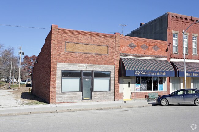
Property Record
1117 Thomas St, Redfield, IA 50233

Property Detail
1117 Thomas St
Des Moines-West Des Moines, IA
W 2/3 OF LOT 7 BLK 1
13-04-142-017
DALLAS
Storebuilding
Iowa
B and X Area of moderate flood hazard, usually the area between the limits of the 100-year and 500-year floods.
7
2025
0.13 AC
2025
Outlying Dallas County
050600
Des Moines
1,694 SF
NEARBY LISTINGS FOR SALE OR LEASE
-
-
View all Redfield listings for sale on LoopNet.com
DEMOGRAPHICS near 1117 Thomas St
1 mile
3 mile
5 mile
2025 Total Population
985
1,335
2,488
2030 Population
1,109
1,496
2,723
Pop Growth 2025-2030
+ 12.59%
+ 12.06%
+ 9.45%
Average Age
43
43
43
2025 Total Households
432
571
1,020
HH Growth 2025-2030
+ 12.96%
+ 12.43%
+ 9.90%
Median Household Inc
$80,037
$82,031
$86,568
Avg Household Size
2.30
2.30
2.40
2025 Avg HH Vehicles
2.00
3.00
3.00
Median Home Value
$134,797
$151,412
$194,313
Median Year Built
1961
1965
1973
Nearby Places
Map Layers
Map Styles
 Street
 Aerial
Layers
 Traffic
 Biking
Places
Listings with unknown addresses are not visible on the map
- Restaurants
- Banks
- Shops
- Fitness
- Groceries
PUBLIC TRANSPORTATION
AIRPORT
Des Moines International
Drive
Walk
Distance
Des Moines International
48 min
38.8 mi
SALE & LEASE HISTORY
LISTING DATE
SALE/LEASE

Feb 25, 2021
For Sale
Apr 27, 2023
For Sale
Nearby Properties
Address
Land Use
TOTAL SIZE
Lot Size
Zoning
Address
Land Use
TOTAL SIZE
Lot Size
Zoning
3.58 AC
Address
Land Use
TOTAL SIZE
Lot Size
Zoning
8,640 SF
33.43 AC
Address
Land Use
TOTAL SIZE
Lot Size
Zoning
3,699 SF
25.96 AC
Address
Land Use
TOTAL SIZE
Lot Size
Zoning
7,128 SF
16.94 AC
Address
Land Use
TOTAL SIZE
Lot Size
Zoning
9,250 SF
2.01 AC
Address
Land Use
TOTAL SIZE
Lot Size
Zoning
3,200 SF
8.96 AC
Address
Land Use
TOTAL SIZE
Lot Size
Zoning
4,000 SF
1.18 AC
Address
Land Use
TOTAL SIZE
Lot Size
Zoning
5,600 SF
0.40 AC
Address
Land Use
TOTAL SIZE
Lot Size
Zoning
2,800 SF
0.70 AC
Address
Land Use
TOTAL SIZE
Lot Size
Zoning
1,360 SF
29.63 AC
Address
Land Use
TOTAL SIZE
Lot Size
Zoning
1,512 SF
4.10 AC
Address
Land Use
TOTAL SIZE
Lot Size
Zoning
3,477 SF
0.23 AC
Address
Land Use
TOTAL SIZE
Lot Size
Zoning
3,492 SF
0.70 AC
Address
Land Use
TOTAL SIZE
Lot Size
Zoning
1,200 SF
0.09 AC
Address
Land Use
TOTAL SIZE
Lot Size
Zoning
7,300 SF
0.56 AC
Address
Land Use
TOTAL SIZE
Lot Size
Zoning
7,196 SF
3.69 AC
Address
Land Use
TOTAL SIZE
Lot Size
Zoning
3,100 SF
0.35 AC
Address
Land Use
TOTAL SIZE
Lot Size
Zoning
3,016 SF
0.35 AC
Address
Land Use
TOTAL SIZE
Lot Size
Zoning
Address
Land Use
TOTAL SIZE
Lot Size
Zoning
1,400 SF
0.30 AC
Address
Land Use
TOTAL SIZE
Lot Size
Zoning
1,950 SF
0.14 AC
Address
Land Use
TOTAL SIZE
Lot Size
Zoning
2,268 SF
0.29 AC
Address
Land Use
TOTAL SIZE
Lot Size
Zoning
3,500 SF
0.13 AC
Address
Land Use
TOTAL SIZE
Lot Size
Zoning
2,860 SF
0.42 AC
Address
Land Use
TOTAL SIZE
Lot Size
Zoning
2,451 SF
0.23 AC
Address
Land Use
TOTAL SIZE
Lot Size
Zoning
1,764 SF
0.18 AC
Address
Land Use
TOTAL SIZE
Lot Size
Zoning
2,160 SF
1.90 AC
Address
Land Use
TOTAL SIZE
Lot Size
Zoning
1,644 SF
0.26 AC
Address
Land Use
TOTAL SIZE
Lot Size
Zoning
742 SF
0.21 AC
Address
Land Use
TOTAL SIZE
Lot Size
Zoning
3,984 SF
0.06 AC
The World's #1 Commercial Real Estate Marketplace
Connect with us
© 2026 CoStar Group
The information above has been obtained from sources believed reliable. While we do not doubt its accuracy we have not verified it and make no guarantee, warranty or representation about it. It is your responsibility to independently confirm its accuracy and completeness. Any projections, opinions, assumptions, or estimates used are for example only and do not represent the current or future performance of the property. The value of this transaction to you depends on tax and other factors which should be evaluated by your tax, financial, and legal advisors. You and your advisors should conduct a careful, independent investigation of the property to determine to your satisfaction the suitability of the property for your needs.