Property Record
1118 E 19Th St, Upland, CA 91784
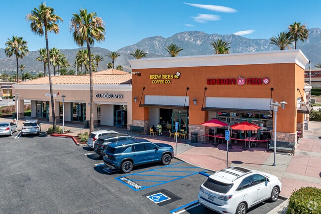


Property Detail
1118 E 19Th St
1044-641-55
PARCEL MAP 16911 PARCEL 6 BOOK 213 PAGE 24
Storebuilding
San Bernardino
B and X Area of moderate flood hazard, usually the area between the limits of the 100-year and 500-year floods.
California
2025
0.86 AC
2025
Upland/Montclair
000819
Inland Empire (California)
8,450 SF
Riverside-San Bernardino-Ontario, CA
NEARBY LISTINGS FOR SALE OR LEASE
DEMOGRAPHICS near 1118 E 19Th St
1 mile
3 mile
5 mile
2025 Total Population
10,440
121,762
301,433
2030 Population
10,545
122,330
303,243
Pop Growth 2025-2030
+ 1.01%
+ 0.47%
+ 0.60%
Average Age
43
41
39
2025 Total Households
3,614
42,770
99,049
HH Growth 2025-2030
+ 0.94%
+ 0.47%
+ 0.62%
Median Household Inc
$159,286
$111,200
$100,131
Avg Household Size
2.80
2.80
2.90
2025 Avg HH Vehicles
3.00
2.00
2.00
Median Home Value
$794,143
$753,528
$733,000
Median Year Built
1985
1977
1979
Nearby Places
Map Layers
Map Styles
 Street
 Aerial
Transit
 Traffic
 Biking
Places
Listings with unknown addresses are not visible on the map
- Restaurants
- Banks
- Shops
- Fitness
- Groceries
PUBLIC TRANSPORTATION
COMMUTER RAIL
Upland (San Bernardino Line - Southern California Regional Rail Authority (Metrolink))
Drive
Walk
Distance
Upland (San Bernardino Line - Southern California Regional Rail Authority (Metrolink))
8 min
3.2 mi
Drive
Walk
Distance
12 min
5.8 mi
AIRPORT
Ontario International
Drive
Walk
Distance
Ontario International
20 min
8.7 mi
John Wayne/Orange County
Drive
Walk
Distance
John Wayne/Orange County
57 min
46.4 mi
Long Beach (Daugherty Field)
Drive
Walk
Distance
Long Beach (Daugherty Field)
62 min
48.7 mi
Freight Ports
Port of Long Beach
Drive
Walk
Distance
Port of Long Beach
69 min
54.4 mi
Nearby Properties
Address
Land Use
TOTAL SIZE
Lot Size
Zoning
Address
Land Use
TOTAL SIZE
Lot Size
Zoning
376,610 SF
25.22 AC
Address
Land Use
TOTAL SIZE
Lot Size
Zoning
167,512 SF
8.35 AC
Address
Land Use
TOTAL SIZE
Lot Size
Zoning
251,645 SF
4.50 AC
Address
Land Use
TOTAL SIZE
Lot Size
Zoning
340,104 SF
8.95 AC
Address
Land Use
TOTAL SIZE
Lot Size
Zoning
249,672 SF
13.80 AC
Address
Land Use
TOTAL SIZE
Lot Size
Zoning
95,240 SF
8.42 AC
Address
Land Use
TOTAL SIZE
Lot Size
Zoning
99,345 SF
5.15 AC
Address
Land Use
TOTAL SIZE
Lot Size
Zoning
203,092 SF
10 AC
Address
Land Use
TOTAL SIZE
Lot Size
Zoning
63,862 SF
4.77 AC
Address
Land Use
TOTAL SIZE
Lot Size
Zoning
455,226 SF
18.15 AC
Address
Land Use
TOTAL SIZE
Lot Size
Zoning
171,446 SF
10.88 AC
Address
Land Use
TOTAL SIZE
Lot Size
Zoning
54,166 SF
4.60 AC
Address
Land Use
TOTAL SIZE
Lot Size
Zoning
175,624 SF
8.20 AC
Address
Land Use
TOTAL SIZE
Lot Size
Zoning
59,690 SF
3.32 AC
Address
Land Use
TOTAL SIZE
Lot Size
Zoning
87,386 SF
3.90 AC
Address
Land Use
TOTAL SIZE
Lot Size
Zoning
54,366 SF
4.95 AC
Address
Land Use
TOTAL SIZE
Lot Size
Zoning
139,921 SF
8.72 AC
Address
Land Use
TOTAL SIZE
Lot Size
Zoning
75,755 SF
3.23 AC
Address
Land Use
TOTAL SIZE
Lot Size
Zoning
145,880 SF
9.76 AC
Address
Land Use
TOTAL SIZE
Lot Size
Zoning
56,467 SF
8.78 AC
Address
Land Use
TOTAL SIZE
Lot Size
Zoning
293,200 SF
17.06 AC
Address
Land Use
TOTAL SIZE
Lot Size
Zoning
122,600 SF
5.94 AC
Address
Land Use
TOTAL SIZE
Lot Size
Zoning
276,070 SF
8.84 AC
Address
Land Use
TOTAL SIZE
Lot Size
Zoning
61,791 SF
2.68 AC
Address
Land Use
TOTAL SIZE
Lot Size
Zoning
159,848 SF
5.30 AC
Address
Land Use
TOTAL SIZE
Lot Size
Zoning
125,452 SF
4.07 AC
Address
Land Use
TOTAL SIZE
Lot Size
Zoning
49,412 SF
2.68 AC
Address
Land Use
TOTAL SIZE
Lot Size
Zoning
50,886 SF
4.94 AC
Address
Land Use
TOTAL SIZE
Lot Size
Zoning
57,260 SF
3.43 AC
Address
Land Use
TOTAL SIZE
Lot Size
Zoning
38,014 SF
2.02 AC
The World's #1 Commercial Real Estate Marketplace
Connect with us
© 2026 CoStar Group
The information above has been obtained from sources believed reliable. While we do not doubt its accuracy we have not verified it and make no guarantee, warranty or representation about it. It is your responsibility to independently confirm its accuracy and completeness. Any projections, opinions, assumptions, or estimates used are for example only and do not represent the current or future performance of the property. The value of this transaction to you depends on tax and other factors which should be evaluated by your tax, financial, and legal advisors. You and your advisors should conduct a careful, independent investigation of the property to determine to your satisfaction the suitability of the property for your needs.