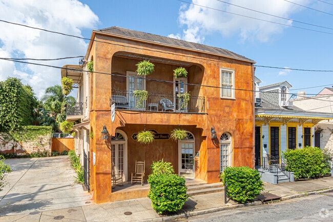
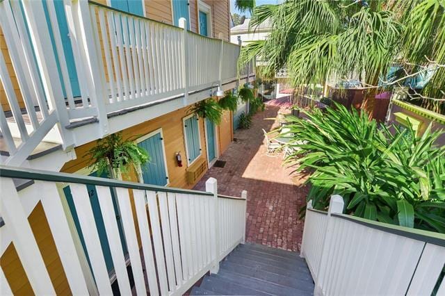
Property Record
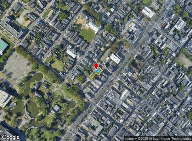
1118 Ursulines Ave, New Orleans, LA 70116
NEARBY LISTINGS FOR SALE OR LEASE
Property Detail
1118 Ursulines Ave
New Orleans-Metairie, LA
2Nd District
2-08-1-030-19
SQ 112 LOT 34 URSULINES 31 X 129 LOT 3 URSULINES 38 X 65 N O GUEST HOUSE
Transientlodging
Orleans
X
Louisiana
22051C0225F
34
2025
0.15 AC
2025
New Orleans CBD/French Quarter
003900
New Orleans/Metairie/Kenner
3,624 SF
DEMOGRAPHICS near 1118 Ursulines Ave
1 Mile
3 Mile
5 Mile
2024 Total Population
25,763
161,836
350,859
2029 Population
25,622
157,290
338,953
Pop Growth 2024-2029
(0.55%)
(2.81%)
(3.39%)
Average Age
44
41
41
2024 Total Households
15,024
78,509
155,763
HH Growth 2024-2029
(0.29%)
(2.73%)
(3.43%)
Median Household Inc
$39,836
$42,988
$50,391
Avg Household Size
1.70
2.00
2.10
2024 Avg HH Vehicles
1.00
1.00
1.00
Median Home Value
$390,102
$309,043
$310,037
Median Year Built
1946
1948
1954
Nearby Places
Map Layers
Map Styles
 Street
 Aerial
- Restaurants
- Banks
- Shops
- Fitness
- Groceries
PUBLIC TRANSPORTATION
TRANSIT/SUBWAY
Ursulines Street Station (Canal-Cemeteries Streetcar - New Orleans Regional Transit Authority Streetcars (New Orleans Streetcars), Canal-Museum Streetcar - New Orleans Regional Transit Authority Streetcars (New Orleans Streetcars), Riverfront Streetcar - New Orleans Regional Transit Authority Streetcars (New Orleans Streetcars))
DRIVE
WALK
Distance
Ursulines Street Station (Canal-Cemeteries Streetcar - New Orleans Regional Transit Authority Streetcars (New Orleans Streetcars), Canal-Museum Streetcar - New Orleans Regional Transit Authority Streetcars (New Orleans Streetcars), Riverfront Streetcar - New Orleans Regional Transit Authority Streetcars (New Orleans Streetcars))
6 min
10 min
0.5 mi
Dumaine Street Station (Canal-Cemeteries Streetcar - New Orleans Regional Transit Authority Streetcars (New Orleans Streetcars), Canal-Museum Streetcar - New Orleans Regional Transit Authority Streetcars (New Orleans Streetcars), Riverfront Streetcar - New Orleans Regional Transit Authority Streetcars (New Orleans Streetcars))
DRIVE
WALK
Distance
Dumaine Street Station (Canal-Cemeteries Streetcar - New Orleans Regional Transit Authority Streetcars (New Orleans Streetcars), Canal-Museum Streetcar - New Orleans Regional Transit Authority Streetcars (New Orleans Streetcars), Riverfront Streetcar - New Orleans Regional Transit Authority Streetcars (New Orleans Streetcars))
5 min
12 min
0.6 mi
Esplanade Avenue Station (Canal-Cemeteries Streetcar - New Orleans Regional Transit Authority Streetcars (New Orleans Streetcars), Canal-Museum Streetcar - New Orleans Regional Transit Authority Streetcars (New Orleans Streetcars), Riverfront Streetcar - New Orleans Regional Transit Authority Streetcars (New Orleans Streetcars))
DRIVE
WALK
Distance
Esplanade Avenue Station (Canal-Cemeteries Streetcar - New Orleans Regional Transit Authority Streetcars (New Orleans Streetcars), Canal-Museum Streetcar - New Orleans Regional Transit Authority Streetcars (New Orleans Streetcars), Riverfront Streetcar - New Orleans Regional Transit Authority Streetcars (New Orleans Streetcars))
4 min
13 min
0.7 mi
Canal and Rampart (Canal-Cemeteries Streetcar - New Orleans Regional Transit Authority Streetcars (New Orleans Streetcars), Canal-Museum Streetcar - New Orleans Regional Transit Authority Streetcars (New Orleans Streetcars))
DRIVE
WALK
Distance
Canal and Rampart (Canal-Cemeteries Streetcar - New Orleans Regional Transit Authority Streetcars (New Orleans Streetcars), Canal-Museum Streetcar - New Orleans Regional Transit Authority Streetcars (New Orleans Streetcars))
3 min
14 min
0.7 mi
Toulouse Street Station (Canal-Cemeteries Streetcar - New Orleans Regional Transit Authority Streetcars (New Orleans Streetcars), Canal-Museum Streetcar - New Orleans Regional Transit Authority Streetcars (New Orleans Streetcars), Riverfront Streetcar - New Orleans Regional Transit Authority Streetcars (New Orleans Streetcars))
DRIVE
WALK
Distance
Toulouse Street Station (Canal-Cemeteries Streetcar - New Orleans Regional Transit Authority Streetcars (New Orleans Streetcars), Canal-Museum Streetcar - New Orleans Regional Transit Authority Streetcars (New Orleans Streetcars), Riverfront Streetcar - New Orleans Regional Transit Authority Streetcars (New Orleans Streetcars))
5 min
16 min
0.8 mi
COMMUTER RAIL
DRIVE
WALK
Distance
5 min
1.7 mi
AIRPORT
Louis Armstrong New Orleans International
DRIVE
WALK
Distance
Louis Armstrong New Orleans International
23 min
15.8 mi
Freight Ports
Port of New Orleans
DRIVE
WALK
Distance
Port of New Orleans
13 min
5.2 mi
SALE & LEASE HISTORY
LISTING DATE
SALE/LEASE

Dec 26, 2024
For Sale
Nearby Properties
Address
Land Use
TOTAL SIZE
Lot Size
Zoning
Address
Land Use
TOTAL SIZE
Lot Size
Zoning
Address
Land Use
TOTAL SIZE
Lot Size
Zoning
300 SF
2.19 AC
LS
Address
Land Use
TOTAL SIZE
Lot Size
Zoning
85,052 SF
2.19 AC
LS
Address
Land Use
TOTAL SIZE
Lot Size
Zoning
44.43 AC
CBD-4
Address
Land Use
TOTAL SIZE
Lot Size
Zoning
66.23 AC
CBD-4
Address
Land Use
TOTAL SIZE
Lot Size
Zoning
834,043 SF
1.40 AC
CBD-2
Address
Land Use
TOTAL SIZE
Lot Size
Zoning
18.31 AC
CBD-4
Address
Land Use
TOTAL SIZE
Lot Size
Zoning
1.87 AC
CBD-2
Address
Land Use
TOTAL SIZE
Lot Size
Zoning
6.64 AC
Address
Land Use
TOTAL SIZE
Lot Size
Zoning
844,362 SF
5.85 AC
CBD-4
Address
Land Use
TOTAL SIZE
Lot Size
Zoning
0.12 AC
Address
Land Use
TOTAL SIZE
Lot Size
Zoning
30.63 AC
Address
Land Use
TOTAL SIZE
Lot Size
Zoning
444,121 SF
1.46 AC
CBD-1
Address
Land Use
TOTAL SIZE
Lot Size
Zoning
0.88 AC
CBD-2
Address
Land Use
TOTAL SIZE
Lot Size
Zoning
22.17 AC
Address
Land Use
TOTAL SIZE
Lot Size
Zoning
725,677 SF
54.19 AC
EC
Address
Land Use
TOTAL SIZE
Lot Size
Zoning
1.91 AC
CBD-1
Address
Land Use
TOTAL SIZE
Lot Size
Zoning
576,962 SF
3.31 AC
CBD-4
Address
Land Use
TOTAL SIZE
Lot Size
Zoning
1.79 AC
Address
Land Use
TOTAL SIZE
Lot Size
Zoning
512,729 SF
6.60 AC
Address
Land Use
TOTAL SIZE
Lot Size
Zoning
1.24 AC
CBD-1
Address
Land Use
TOTAL SIZE
Lot Size
Zoning
190,708 SF
1.09 AC
CBD-2
Address
Land Use
TOTAL SIZE
Lot Size
Zoning
225,284 SF
16.83 AC
S-RD
Address
Land Use
TOTAL SIZE
Lot Size
Zoning
499,287 SF
1.44 AC
VCE
Address
Land Use
TOTAL SIZE
Lot Size
Zoning
0.67 AC
CBD-3
Address
Land Use
TOTAL SIZE
Lot Size
Zoning
202,291 SF
4.04 AC
HU-RD2
Address
Land Use
TOTAL SIZE
Lot Size
Zoning
162,382 SF
1.25 AC
CBD-2
Address
Land Use
TOTAL SIZE
Lot Size
Zoning
258,024 SF
0.63 AC
CBD-2
Address
Land Use
TOTAL SIZE
Lot Size
Zoning
2.94 AC
CBD-1
Address
Land Use
TOTAL SIZE
Lot Size
Zoning
462,672 SF
1.11 AC
CBD-1
The World's #1 Commercial Real Estate Marketplace
Connect with us
© 2025 CoStar Group
The information above has been obtained from sources believed reliable. While we do not doubt its accuracy we have not verified it and make no guarantee, warranty or representation about it. It is your responsibility to independently confirm its accuracy and completeness. Any projections, opinions, assumptions, or estimates used are for example only and do not represent the current or future performance of the property. The value of this transaction to you depends on tax and other factors which should be evaluated by your tax, financial, and legal advisors. You and your advisors should conduct a careful, independent investigation of the property to determine to your satisfaction the suitability of the property for your needs.