Property Record
1119 Cherry Ridge Dr, Jonesborough, TN 37659
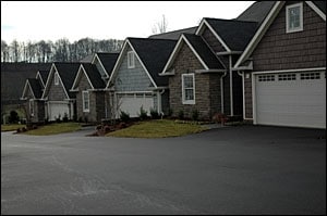

Property Detail
1119 Cherry Ridge Dr
Johnson City, TN
JOHN CARTER PB: 2 PG: 114 BLK: I LOT: 18 CHERRY RIDGE RD 1117-1119-1121-1123; 2019 COUNTY BOARD N/C 16 UNITS 2BR;1B
059D-A-007.00
WASHINGTON
Commercialnec
Tennessee
B and X Area of moderate flood hazard, usually the area between the limits of the 100-year and 500-year floods.
18
2024
1.35 AC
2025
Bristol/Kingsport
061701
Other Market Areas
15,840 SF
NEARBY LISTINGS FOR SALE OR LEASE
-
-
View all Jonesborough listings for sale on LoopNet.com
DEMOGRAPHICS near 1119 Cherry Ridge Dr
1 mile
3 mile
5 mile
2025 Total Population
3,496
14,316
32,465
2030 Population
3,663
15,011
34,053
Pop Growth 2025-2030
+ 4.78%
+ 4.85%
+ 4.89%
Average Age
43
44
43
2025 Total Households
1,300
5,767
13,232
HH Growth 2025-2030
+ 5.08%
+ 5.01%
+ 5.00%
Median Household Inc
$74,427
$73,242
$72,030
Avg Household Size
2.40
2.40
2.40
2025 Avg HH Vehicles
2.00
2.00
2.00
Median Home Value
$358,389
$306,125
$283,875
Median Year Built
1994
1993
1991
Nearby Places
Map Layers
Map Styles
 Street
 Aerial
Layers
 Traffic
 Biking
Places
Listings with unknown addresses are not visible on the map
- Restaurants
- Banks
- Shops
- Fitness
- Groceries
PUBLIC TRANSPORTATION
AIRPORT
Tri-Cities
Drive
Walk
Distance
Tri-Cities
29 min
17.7 mi
Freight Ports
North Charleston Terminal
Drive
Walk
Distance
North Charleston Terminal
368 min
317.6 mi
Nearby Properties
Address
Land Use
TOTAL SIZE
Lot Size
Zoning
Address
Land Use
TOTAL SIZE
Lot Size
Zoning
136,088 SF
11.50 AC
R4
Address
Land Use
TOTAL SIZE
Lot Size
Zoning
62,380 SF
6.66 AC
Address
Land Use
TOTAL SIZE
Lot Size
Zoning
9,490 SF
0.16 AC
HB-2
Address
Land Use
TOTAL SIZE
Lot Size
Zoning
124,333 SF
17.68 AC
B3
Address
Land Use
TOTAL SIZE
Lot Size
Zoning
53,701 SF
7.60 AC
B3
Address
Land Use
TOTAL SIZE
Lot Size
Zoning
56,681 SF
15.37 AC
B3
Address
Land Use
TOTAL SIZE
Lot Size
Zoning
67,656 SF
5.36 AC
Address
Land Use
TOTAL SIZE
Lot Size
Zoning
78,512 SF
5.41 AC
Address
Land Use
TOTAL SIZE
Lot Size
Zoning
Address
Land Use
TOTAL SIZE
Lot Size
Zoning
40,384 SF
2.52 AC
Address
Land Use
TOTAL SIZE
Lot Size
Zoning
43,455 SF
2.29 AC
Address
Land Use
TOTAL SIZE
Lot Size
Zoning
37,042 SF
3.32 AC
Address
Land Use
TOTAL SIZE
Lot Size
Zoning
37,960 SF
3.17 AC
Address
Land Use
TOTAL SIZE
Lot Size
Zoning
6,238 SF
9.90 AC
B3
Address
Land Use
TOTAL SIZE
Lot Size
Zoning
60,511 SF
6.17 AC
R2
Address
Land Use
TOTAL SIZE
Lot Size
Zoning
30,244 SF
2.75 AC
HR-3
Address
Land Use
TOTAL SIZE
Lot Size
Zoning
29,685 SF
3.02 AC
B3
Address
Land Use
TOTAL SIZE
Lot Size
Zoning
30,654 SF
2 AC
Address
Land Use
TOTAL SIZE
Lot Size
Zoning
5,706 SF
1.41 AC
B-3
Address
Land Use
TOTAL SIZE
Lot Size
Zoning
15,926 SF
97.58 AC
Address
Land Use
TOTAL SIZE
Lot Size
Zoning
19,504 SF
5.73 AC
Address
Land Use
TOTAL SIZE
Lot Size
Zoning
12,746 SF
2.36 AC
B3
Address
Land Use
TOTAL SIZE
Lot Size
Zoning
14,736 SF
2.30 AC
B6B3
Address
Land Use
TOTAL SIZE
Lot Size
Zoning
30,700 SF
5.85 AC
Address
Land Use
TOTAL SIZE
Lot Size
Zoning
20,475 SF
1.04 AC
Address
Land Use
TOTAL SIZE
Lot Size
Zoning
12,000 SF
2.13 AC
B6
Address
Land Use
TOTAL SIZE
Lot Size
Zoning
20,268 SF
4.87 AC
Address
Land Use
TOTAL SIZE
Lot Size
Zoning
82,234 SF
36 AC
Address
Land Use
TOTAL SIZE
Lot Size
Zoning
3,639 SF
1.78 AC
B3
Address
Land Use
TOTAL SIZE
Lot Size
Zoning
The World's #1 Commercial Real Estate Marketplace
Connect with us
© 2026 CoStar Group
The information above has been obtained from sources believed reliable. While we do not doubt its accuracy we have not verified it and make no guarantee, warranty or representation about it. It is your responsibility to independently confirm its accuracy and completeness. Any projections, opinions, assumptions, or estimates used are for example only and do not represent the current or future performance of the property. The value of this transaction to you depends on tax and other factors which should be evaluated by your tax, financial, and legal advisors. You and your advisors should conduct a careful, independent investigation of the property to determine to your satisfaction the suitability of the property for your needs.