Property Record
1119 Morningside Dr, Perry, GA 31069

Save to a Folder
{{folder.Name}}
{{folder.ListingIds.length}} Properties
{{folder.ListingIds.length}} Property
Create a New Folder
Property Detail
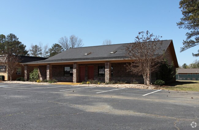
1119 Morningside Dr
0P043002M000
PARCEL B3 PB 73/28 81/10TH
Medicalbuilding
HOUSTON
C2
Georgia
B and X Area of moderate flood hazard, usually the area between the limits of the 100-year and 500-year floods.
81
2025
0.55 AC
2025
Other Market Areas
021401
Warner Robins, GA
3,420 SF
NEARBY LISTINGS FOR SALE OR LEASE
DEMOGRAPHICS near 1119 Morningside Dr
1 mile
3 mile
5 mile
2025 Total Population
5,346
18,515
30,963
2030 Population
5,650
19,701
32,994
Pop Growth 2025-2030
+ 5.69%
+ 6.41%
+ 6.56%
Average Age
39
39
39
2025 Total Households
1,936
7,095
11,684
HH Growth 2025-2030
+ 5.73%
+ 6.55%
+ 6.69%
Median Household Inc
$54,866
$71,200
$78,854
Avg Household Size
2.50
2.50
2.50
2025 Avg HH Vehicles
2.00
2.00
2.00
Median Home Value
$189,390
$221,230
$238,372
Median Year Built
1979
1993
2001
Nearby Places
Map Layers
Map Styles
 Street
 Aerial
Layers
 Traffic
 Biking
Places
Listings with unknown addresses are not visible on the map
- Restaurants
- Banks
- Shops
- Fitness
- Groceries
SALE & LEASE HISTORY
LISTING DATE
SALE/LEASE

Sep 25, 2016
For Lease
Sep 24, 2016
For Sale
Nearby Properties
Address
Land Use
TOTAL SIZE
Lot Size
Zoning
Address
Land Use
TOTAL SIZE
Lot Size
Zoning
68,186 SF
559.30 AC
GU
Address
Land Use
TOTAL SIZE
Lot Size
Zoning
147,496 SF
66.05 AC
GU
Address
Land Use
TOTAL SIZE
Lot Size
Zoning
106,055 SF
22.72 AC
GU
Address
Land Use
TOTAL SIZE
Lot Size
Zoning
262,500 SF
20 AC
GU
Address
Land Use
TOTAL SIZE
Lot Size
Zoning
151,845 SF
17.55 AC
C2
Address
Land Use
TOTAL SIZE
Lot Size
Zoning
2,303 SF
24.71 AC
RM-2
Address
Land Use
TOTAL SIZE
Lot Size
Zoning
2,616 SF
16.65 AC
RM-2
Address
Land Use
TOTAL SIZE
Lot Size
Zoning
2,568 SF
10.30 AC
RM-2
Address
Land Use
TOTAL SIZE
Lot Size
Zoning
49,947 SF
4.03 AC
C2
Address
Land Use
TOTAL SIZE
Lot Size
Zoning
59,290 SF
12.29 AC
C2
Address
Land Use
TOTAL SIZE
Lot Size
Zoning
158,300 SF
30 AC
GU
Address
Land Use
TOTAL SIZE
Lot Size
Zoning
91,249 SF
15.85 AC
GU
Address
Land Use
TOTAL SIZE
Lot Size
Zoning
52,336 SF
3.07 AC
C1
Address
Land Use
TOTAL SIZE
Lot Size
Zoning
54,120 SF
8.18 AC
C1
Address
Land Use
TOTAL SIZE
Lot Size
Zoning
54,120 SF
8.18 AC
C1
Address
Land Use
TOTAL SIZE
Lot Size
Zoning
44,292 SF
9.70 AC
FBR
Address
Land Use
TOTAL SIZE
Lot Size
Zoning
49,331 SF
5.56 AC
C2
Address
Land Use
TOTAL SIZE
Lot Size
Zoning
255.39 AC
GU/M1
Address
Land Use
TOTAL SIZE
Lot Size
Zoning
78,800 SF
7.93 AC
C2
Address
Land Use
TOTAL SIZE
Lot Size
Zoning
98,871 SF
8.09 AC
C2
Address
Land Use
TOTAL SIZE
Lot Size
Zoning
19,810 SF
79.64 AC
GU
Address
Land Use
TOTAL SIZE
Lot Size
Zoning
226.03 AC
GU
Address
Land Use
TOTAL SIZE
Lot Size
Zoning
41,985 SF
1.65 AC
C1/C2
Address
Land Use
TOTAL SIZE
Lot Size
Zoning
51,780 SF
2.50 AC
C1
Address
Land Use
TOTAL SIZE
Lot Size
Zoning
78,010 SF
20 AC
C2
Address
Land Use
TOTAL SIZE
Lot Size
Zoning
68,762 SF
2 AC
C2
Address
Land Use
TOTAL SIZE
Lot Size
Zoning
4,052 SF
15.17 AC
RM-2
Address
Land Use
TOTAL SIZE
Lot Size
Zoning
4,704 SF
107.57 AC
C1 R3 R1
Address
Land Use
TOTAL SIZE
Lot Size
Zoning
13,888 SF
2.90 AC
C1
Address
Land Use
TOTAL SIZE
Lot Size
Zoning
38,475 SF
16.77 AC
C1
The World's #1 Commercial Real Estate Marketplace
Connect with us
© 2026 CoStar Group
The information above has been obtained from sources believed reliable. While we do not doubt its accuracy we have not verified it and make no guarantee, warranty or representation about it. It is your responsibility to independently confirm its accuracy and completeness. Any projections, opinions, assumptions, or estimates used are for example only and do not represent the current or future performance of the property. The value of this transaction to you depends on tax and other factors which should be evaluated by your tax, financial, and legal advisors. You and your advisors should conduct a careful, independent investigation of the property to determine to your satisfaction the suitability of the property for your needs.