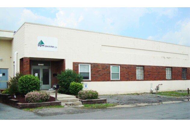
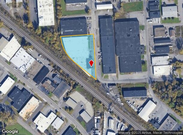
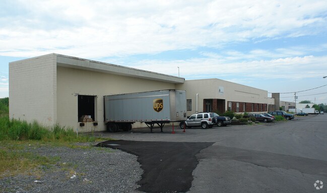
Property Record
112 Baker St, Syracuse, NY 13206

NEARBY LISTINGS FOR SALE OR LEASE
Property Detail
112 Baker St
312689-031-000-0001-003-000-0000
FL 29,CTV D 28TO37,PT BL
Warehouse
Onondaga
X
New York
36067C0228F
3.000
2025
2 AC
2024
SE Outer Onondaga County
014400
Syracuse
50,000 SF
Syracuse, NY
DEMOGRAPHICS near 112 Baker St
1 Mile
3 Mile
5 Mile
2024 Total Population
7,988
93,016
203,189
2029 Population
7,745
90,684
198,621
Pop Growth 2024-2029
(3.04%)
(2.51%)
(2.25%)
Average Age
40
38
38
2024 Total Households
3,927
39,169
83,821
HH Growth 2024-2029
(3.28%)
(2.51%)
(2.34%)
Median Household Inc
$40,100
$46,038
$50,971
Avg Household Size
2.00
2.20
2.20
2024 Avg HH Vehicles
1.00
1.00
1.00
Median Home Value
$110,093
$122,170
$143,630
Median Year Built
1952
1950
1954
Nearby Places
Map Layers
Map Styles
 Street
 Aerial
- Restaurants
- Banks
- Shops
- Fitness
- Groceries
PUBLIC TRANSPORTATION
COMMUTER RAIL
Syracuse Regional Transportation Center (Empire Service - Amtrak, Lake Shore Limited - Amtrak, Maple Leaf - Amtrak)
DRIVE
WALK
Distance
Syracuse Regional Transportation Center (Empire Service - Amtrak, Lake Shore Limited - Amtrak, Maple Leaf - Amtrak)
9 min
4.2 mi
Syracuse (Toronto - New York - VIA Rail)
DRIVE
WALK
Distance
Syracuse (Toronto - New York - VIA Rail)
9 min
4.2 mi
AIRPORT
Syracuse Hancock International
DRIVE
WALK
Distance
Syracuse Hancock International
13 min
6.0 mi
Freight Ports
Albany, NY Port
DRIVE
WALK
Distance
Albany, NY Port
167 min
140.9 mi
SALE & LEASE HISTORY
LISTING DATE
SALE/LEASE

Sep 25, 2016
For Lease
Sep 24, 2016
For Sale
Sep 23, 2016
For Sale
Mar 17, 2017
For Sale
Nearby Properties
Address
Land Use
TOTAL SIZE
Lot Size
Zoning
Address
Land Use
TOTAL SIZE
Lot Size
Zoning
508,658 SF
2.23 AC
25
Address
Land Use
TOTAL SIZE
Lot Size
Zoning
72,200 SF
12.39 AC
06 - INDUS
Address
Land Use
TOTAL SIZE
Lot Size
Zoning
409,062 SF
10
Address
Land Use
TOTAL SIZE
Lot Size
Zoning
38,693 SF
102.34 AC
05 - COMME
Address
Land Use
TOTAL SIZE
Lot Size
Zoning
24,360 SF
3.99 AC
10
Address
Land Use
TOTAL SIZE
Lot Size
Zoning
414,700 SF
1.94 AC
07 - MIXED
Address
Land Use
TOTAL SIZE
Lot Size
Zoning
2,709 SF
39.74 AC
06 - INDUS
Address
Land Use
TOTAL SIZE
Lot Size
Zoning
224,736 SF
2.48 AC
10
Address
Land Use
TOTAL SIZE
Lot Size
Zoning
165,800 SF
1.27 AC
25
Address
Land Use
TOTAL SIZE
Lot Size
Zoning
164,837 SF
0.66 AC
10
Address
Land Use
TOTAL SIZE
Lot Size
Zoning
105,004 SF
2.81 AC
25
Address
Land Use
TOTAL SIZE
Lot Size
Zoning
569,463 SF
94.77 AC
06 - INDUS
Address
Land Use
TOTAL SIZE
Lot Size
Zoning
296,703 SF
1.48 AC
25
Address
Land Use
TOTAL SIZE
Lot Size
Zoning
12,836 SF
148.95 AC
06 - INDUS
Address
Land Use
TOTAL SIZE
Lot Size
Zoning
116,580 SF
18.46 AC
06 - INDUS
Address
Land Use
TOTAL SIZE
Lot Size
Zoning
169,752 SF
12.81 AC
04 - FARM
Address
Land Use
TOTAL SIZE
Lot Size
Zoning
217,709 SF
34.53 AC
01 - NOT Z
Address
Land Use
TOTAL SIZE
Lot Size
Zoning
432,246 SF
37.21 AC
05 - COMME
Address
Land Use
TOTAL SIZE
Lot Size
Zoning
174,750 SF
10.40 AC
06 - INDUS
Address
Land Use
TOTAL SIZE
Lot Size
Zoning
104,400 SF
12.84 AC
06 - INDUS
Address
Land Use
TOTAL SIZE
Lot Size
Zoning
22.16 AC
06 - INDUS
Address
Land Use
TOTAL SIZE
Lot Size
Zoning
17,388 SF
26.51 AC
07 - MIXED
Address
Land Use
TOTAL SIZE
Lot Size
Zoning
11,484 SF
16.36 AC
03 - MULTI
Address
Land Use
TOTAL SIZE
Lot Size
Zoning
115,000 SF
07 - MIXED
Address
Land Use
TOTAL SIZE
Lot Size
Zoning
37,045 SF
5.58 AC
06 - INDUS
Address
Land Use
TOTAL SIZE
Lot Size
Zoning
297,376 SF
1.88 AC
13
Address
Land Use
TOTAL SIZE
Lot Size
Zoning
157,497 SF
14.56 AC
06 - INDUS
Address
Land Use
TOTAL SIZE
Lot Size
Zoning
86,136 SF
0.80 AC
025
Address
Land Use
TOTAL SIZE
Lot Size
Zoning
40,684 SF
1.62 AC
08 - GOVER
The World's #1 Commercial Real Estate Marketplace
Connect with us
© 2026 CoStar Group
The information above has been obtained from sources believed reliable. While we do not doubt its accuracy we have not verified it and make no guarantee, warranty or representation about it. It is your responsibility to independently confirm its accuracy and completeness. Any projections, opinions, assumptions, or estimates used are for example only and do not represent the current or future performance of the property. The value of this transaction to you depends on tax and other factors which should be evaluated by your tax, financial, and legal advisors. You and your advisors should conduct a careful, independent investigation of the property to determine to your satisfaction the suitability of the property for your needs.