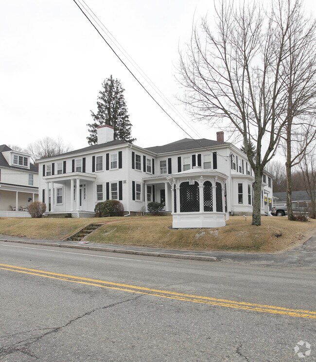
Property Record
112 Main St, Upton, MA 01568

Property Detail
112 Main St
UPTO-000203-000000-000110
Worcester
Commercialnec
Massachusetts
1
110
B and X Area of moderate flood hazard, usually the area between the limits of the 100-year and 500-year floods.
0.79 AC
2025
Outlying Worcester
2025
Boston
743100
Worcester, MA
8,228 SF
NEARBY LISTINGS FOR SALE OR LEASE
DEMOGRAPHICS near 112 Main St
1 mile
3 mile
5 mile
2025 Total Population
3,667
15,659
63,869
2030 Population
3,779
16,118
65,728
Pop Growth 2025-2030
+ 3.05%
+ 2.93%
+ 2.91%
Average Age
42
42
42
2025 Total Households
1,412
5,857
23,867
HH Growth 2025-2030
+ 3.05%
+ 2.97%
+ 3.01%
Median Household Inc
$122,147
$138,440
$129,134
Avg Household Size
2.60
2.60
2.60
2025 Avg HH Vehicles
2.00
2.00
2.00
Median Home Value
$573,451
$589,455
$570,199
Median Year Built
1962
1981
1978
Nearby Places
Map Layers
Map Styles
 Street
 Aerial
Transit
 Traffic
 Biking
Places
Listings with unknown addresses are not visible on the map
- Restaurants
- Banks
- Shops
- Fitness
- Groceries
PUBLIC TRANSPORTATION
COMMUTER RAIL
Grafton (Framingham/Worcester Line - Massachusetts Bay Transportation Authority Commuter Rail (Purple Line))
Drive
Walk
Distance
Grafton (Framingham/Worcester Line - Massachusetts Bay Transportation Authority Commuter Rail (Purple Line))
19 min
8.8 mi
Southborough (Framingham/Worcester Line - Massachusetts Bay Transportation Authority Commuter Rail (Purple Line))
Drive
Walk
Distance
Southborough (Framingham/Worcester Line - Massachusetts Bay Transportation Authority Commuter Rail (Purple Line))
17 min
9.6 mi
AIRPORT
Worcester Regional
Drive
Walk
Distance
Worcester Regional
36 min
19.5 mi
General Edward Lawrence Logan International
Drive
Walk
Distance
General Edward Lawrence Logan International
57 min
41.4 mi
Rhode Island Tf Green International
Drive
Walk
Distance
Rhode Island Tf Green International
61 min
41.4 mi
Freight Ports
Port of Boston
Drive
Walk
Distance
Port of Boston
57 min
39.7 mi
Nearby Properties
Address
Land Use
TOTAL SIZE
Lot Size
Zoning
Address
Land Use
TOTAL SIZE
Lot Size
Zoning
147,000 SF
28.41 AC
5
Address
Land Use
TOTAL SIZE
Lot Size
Zoning
159,250 SF
28.89 AC
2
Address
Land Use
TOTAL SIZE
Lot Size
Zoning
99,891 SF
17.37 AC
1
Address
Land Use
TOTAL SIZE
Lot Size
Zoning
2,576 SF
3.37 AC
5
Address
Land Use
TOTAL SIZE
Lot Size
Zoning
12.65 AC
Address
Land Use
TOTAL SIZE
Lot Size
Zoning
51,441 SF
3.50 AC
3
Address
Land Use
TOTAL SIZE
Lot Size
Zoning
87,250 SF
4.46 AC
6
Address
Land Use
TOTAL SIZE
Lot Size
Zoning
17.12 AC
Address
Land Use
TOTAL SIZE
Lot Size
Zoning
26.11 AC
Address
Land Use
TOTAL SIZE
Lot Size
Zoning
1.79 AC
Address
Land Use
TOTAL SIZE
Lot Size
Zoning
23,326 SF
33.14 AC
7
Address
Land Use
TOTAL SIZE
Lot Size
Zoning
146.25 AC
Address
Land Use
TOTAL SIZE
Lot Size
Zoning
5.78 AC
OLI
Address
Land Use
TOTAL SIZE
Lot Size
Zoning
22,864 SF
3.96 AC
1
Address
Land Use
TOTAL SIZE
Lot Size
Zoning
43,280 SF
4.58 AC
N/A
Address
Land Use
TOTAL SIZE
Lot Size
Zoning
30,821 SF
3.83 AC
Address
Land Use
TOTAL SIZE
Lot Size
Zoning
16,998 SF
42.57 AC
5
Address
Land Use
TOTAL SIZE
Lot Size
Zoning
1.34 AC
Address
Land Use
TOTAL SIZE
Lot Size
Zoning
25,345 SF
2.14 AC
6
Address
Land Use
TOTAL SIZE
Lot Size
Zoning
42,356 SF
7.14 AC
OLI
Address
Land Use
TOTAL SIZE
Lot Size
Zoning
4.16 AC
R8
Address
Land Use
TOTAL SIZE
Lot Size
Zoning
13,520 SF
1.40 AC
R8
Address
Land Use
TOTAL SIZE
Lot Size
Zoning
Address
Land Use
TOTAL SIZE
Lot Size
Zoning
27,082 SF
0.79 AC
Address
Land Use
TOTAL SIZE
Lot Size
Zoning
564.75 AC
Address
Land Use
TOTAL SIZE
Lot Size
Zoning
17,728 SF
1.45 AC
6
Address
Land Use
TOTAL SIZE
Lot Size
Zoning
16,383 SF
0.24 AC
1
Address
Land Use
TOTAL SIZE
Lot Size
Zoning
22,232 SF
2.04 AC
3
Address
Land Use
TOTAL SIZE
Lot Size
Zoning
3,168 SF
47.84 AC
Address
Land Use
TOTAL SIZE
Lot Size
Zoning
179 AC
R4
The World's #1 Commercial Real Estate Marketplace
Connect with us
© 2026 CoStar Group
The information above has been obtained from sources believed reliable. While we do not doubt its accuracy we have not verified it and make no guarantee, warranty or representation about it. It is your responsibility to independently confirm its accuracy and completeness. Any projections, opinions, assumptions, or estimates used are for example only and do not represent the current or future performance of the property. The value of this transaction to you depends on tax and other factors which should be evaluated by your tax, financial, and legal advisors. You and your advisors should conduct a careful, independent investigation of the property to determine to your satisfaction the suitability of the property for your needs.