Property Record
112 Mango Tree Dr, Edgewater, FL 32132
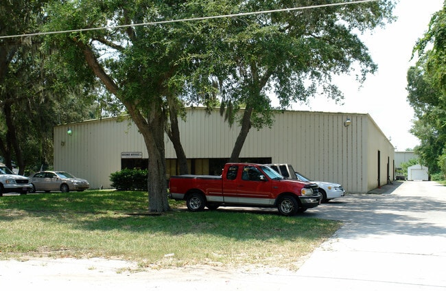

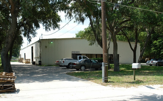

Property Detail
112 Mango Tree Dr
7452-01-00-0438
52-17-34 E 321.32 FT OF S 130 0F N 380 FT OF LOT 37 ASSRS SUB ALVAREZ GRANT MB 3 PG 137 PER OR 5253 PGS 0340-0341 PER OR 6321 PG 2751 PER OR 6321 PG 2755 PER OR 8622 PG 3262
Lightindustrial
Volusia
07I1
Florida
B and X Area of moderate flood hazard, usually the area between the limits of the 100-year and 500-year floods.
37
2025
0.96 AC
2026
South Beach Cities
083009
Deltona/Daytona Beach
15,708 SF
Deltona-Daytona Beach-Ormond Beach, FL
NEARBY LISTINGS FOR SALE OR LEASE
DEMOGRAPHICS near 112 Mango Tree Dr
1 mile
3 mile
5 mile
2025 Total Population
4,655
36,050
62,166
2030 Population
4,986
39,361
68,204
Pop Growth 2025-2030
+ 7.11%
+ 9.18%
+ 9.71%
Average Age
46
49
50
2025 Total Households
1,871
16,177
28,843
HH Growth 2025-2030
+ 7.06%
+ 9.54%
+ 10.02%
Median Household Inc
$51,559
$62,314
$68,281
Avg Household Size
2.20
2.10
2.10
2025 Avg HH Vehicles
2.00
2.00
2.00
Median Home Value
$280,885
$355,822
$370,964
Median Year Built
1977
1983
1986
Nearby Places
Map Layers
Map Styles
 Street
 Aerial
Layers
 Traffic
 Biking
Places
Listings with unknown addresses are not visible on the map
- Restaurants
- Banks
- Shops
- Fitness
- Groceries
PUBLIC TRANSPORTATION
AIRPORT
Daytona Beach International
Drive
Walk
Distance
Daytona Beach International
34 min
21.7 mi
Orlando Sanford International
Drive
Walk
Distance
Orlando Sanford International
55 min
35.5 mi
Freight Ports
Port Canaveral
Drive
Walk
Distance
Port Canaveral
71 min
56.5 mi
Nearby Properties
Address
Land Use
TOTAL SIZE
Lot Size
Zoning
Address
Land Use
TOTAL SIZE
Lot Size
Zoning
360,394 SF
65.63 AC
01R4
Address
Land Use
TOTAL SIZE
Lot Size
Zoning
177,619 SF
6.91 AC
10R2
Address
Land Use
TOTAL SIZE
Lot Size
Zoning
209,027 SF
29.13 AC
10R2A
Address
Land Use
TOTAL SIZE
Lot Size
Zoning
150,044 SF
19.80 AC
R4
Address
Land Use
TOTAL SIZE
Lot Size
Zoning
68,493 SF
1.89 AC
10B6
Address
Land Use
TOTAL SIZE
Lot Size
Zoning
23,142 SF
7.98 AC
R
Address
Land Use
TOTAL SIZE
Lot Size
Zoning
91,509 SF
4.06 AC
I1
Address
Land Use
TOTAL SIZE
Lot Size
Zoning
91,759 SF
10.15 AC
10B2
Address
Land Use
TOTAL SIZE
Lot Size
Zoning
5,249 SF
0.42 AC
01MH5
Address
Land Use
TOTAL SIZE
Lot Size
Zoning
87,154 SF
1.08 AC
10R5
Address
Land Use
TOTAL SIZE
Lot Size
Zoning
94,251 SF
18.51 AC
Address
Land Use
TOTAL SIZE
Lot Size
Zoning
111,686 SF
10.03 AC
10B5
Address
Land Use
TOTAL SIZE
Lot Size
Zoning
55,587 SF
85.39 AC
R4
Address
Land Use
TOTAL SIZE
Lot Size
Zoning
119,537 SF
12.06 AC
PUD
Address
Land Use
TOTAL SIZE
Lot Size
Zoning
44,239 SF
2.31 AC
10B1
Address
Land Use
TOTAL SIZE
Lot Size
Zoning
229,941 SF
0.57 AC
10R2A
Address
Land Use
TOTAL SIZE
Lot Size
Zoning
2,628 SF
3.04 AC
Address
Land Use
TOTAL SIZE
Lot Size
Zoning
64,123 SF
6.94 AC
07B5
Address
Land Use
TOTAL SIZE
Lot Size
Zoning
98,105 SF
8.03 AC
07B3
Address
Land Use
TOTAL SIZE
Lot Size
Zoning
108,762 SF
11.60 AC
RA
Address
Land Use
TOTAL SIZE
Lot Size
Zoning
41,310 SF
1.57 AC
10B1
Address
Land Use
TOTAL SIZE
Lot Size
Zoning
70,088 SF
0.30 AC
10R5
Address
Land Use
TOTAL SIZE
Lot Size
Zoning
73,711 SF
7.06 AC
R2
Address
Land Use
TOTAL SIZE
Lot Size
Zoning
89,757 SF
12.19 AC
07B5
Address
Land Use
TOTAL SIZE
Lot Size
Zoning
11,516 SF
3.67 AC
10R5
Address
Land Use
TOTAL SIZE
Lot Size
Zoning
53,729 SF
12.70 AC
10R1
Address
Land Use
TOTAL SIZE
Lot Size
Zoning
79,518 SF
8.69 AC
B3
Address
Land Use
TOTAL SIZE
Lot Size
Zoning
56,841 SF
8.81 AC
B4C
Address
Land Use
TOTAL SIZE
Lot Size
Zoning
6.39 AC
B5
Address
Land Use
TOTAL SIZE
Lot Size
Zoning
71,824 SF
2.01 AC
10R5
The World's #1 Commercial Real Estate Marketplace
Connect with us
© 2026 CoStar Group
The information above has been obtained from sources believed reliable. While we do not doubt its accuracy we have not verified it and make no guarantee, warranty or representation about it. It is your responsibility to independently confirm its accuracy and completeness. Any projections, opinions, assumptions, or estimates used are for example only and do not represent the current or future performance of the property. The value of this transaction to you depends on tax and other factors which should be evaluated by your tax, financial, and legal advisors. You and your advisors should conduct a careful, independent investigation of the property to determine to your satisfaction the suitability of the property for your needs.