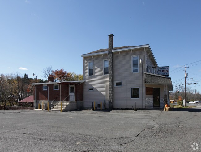
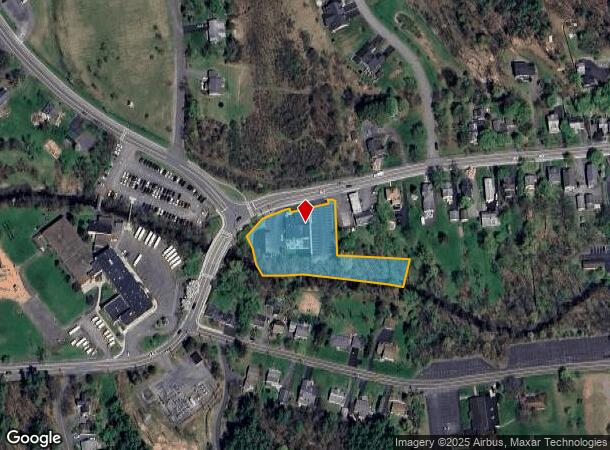
Property Record
112 Maple Ave, Voorheesville, NY 12186


NEARBY LISTINGS FOR SALE OR LEASE
Property Detail
112 Maple Ave
013401-072-011-0003-004-000-0000
1.-166-14 CREEK MAPLE AVE RES & REST
Restaurantbuilding
Albany
AE
New York
36001C0168D
4.000
2025
1.53 AC
2024
W Outer Albany County
014503
Albany/Schenectady/Troy
3,368 SF
Albany-Schenectady-Troy, NY
DEMOGRAPHICS near 112 Maple Ave
1 Mile
3 Mile
5 Mile
2024 Total Population
3,047
8,834
37,632
2029 Population
3,021
8,777
37,545
Pop Growth 2024-2029
(0.85%)
(0.65%)
(0.23%)
Average Age
43
44
43
2024 Total Households
1,216
3,516
16,237
HH Growth 2024-2029
(0.82%)
(0.57%)
(0.13%)
Median Household Inc
$98,445
$108,011
$92,211
Avg Household Size
2.50
2.50
2.30
2024 Avg HH Vehicles
2.00
2.00
2.00
Median Home Value
$262,212
$333,368
$321,508
Median Year Built
1969
1975
1976
Nearby Places
Map Layers
Map Styles
 Street
 Aerial
- Restaurants
- Banks
- Shops
- Fitness
- Groceries
PUBLIC TRANSPORTATION
AIRPORT
Albany International
DRIVE
WALK
Distance
Albany International
27 min
14.3 mi
Freight Ports
Albany, NY Port
DRIVE
WALK
Distance
Albany, NY Port
22 min
11.9 mi
SALE & LEASE HISTORY
LISTING DATE
SALE/LEASE

Oct 13, 2021
For Sale
Jun 22, 2018
For Sale
Nearby Properties
Address
Land Use
TOTAL SIZE
Lot Size
Zoning
Address
Land Use
TOTAL SIZE
Lot Size
Zoning
497.90 AC
RA
Address
Land Use
TOTAL SIZE
Lot Size
Zoning
121,137 SF
5.92 AC
PUD
Address
Land Use
TOTAL SIZE
Lot Size
Zoning
74,167 SF
8.80 AC
PUD
Address
Land Use
TOTAL SIZE
Lot Size
Zoning
132,294 SF
35 AC
RA
Address
Land Use
TOTAL SIZE
Lot Size
Zoning
11,516 SF
131 AC
RA3
Address
Land Use
TOTAL SIZE
Lot Size
Zoning
3,200 SF
231.30 AC
RA3
Address
Land Use
TOTAL SIZE
Lot Size
Zoning
63,740 SF
3 AC
V1
Address
Land Use
TOTAL SIZE
Lot Size
Zoning
189,116 SF
7.60 AC
IN
Address
Land Use
TOTAL SIZE
Lot Size
Zoning
28,332 SF
844.23 AC
F
Address
Land Use
TOTAL SIZE
Lot Size
Zoning
2,592 SF
244.23 AC
RA
Address
Land Use
TOTAL SIZE
Lot Size
Zoning
78,295 SF
44.50 AC
V7
Address
Land Use
TOTAL SIZE
Lot Size
Zoning
27.20 AC
RA
Address
Land Use
TOTAL SIZE
Lot Size
Zoning
9,175 SF
0.01 AC
PDD
Address
Land Use
TOTAL SIZE
Lot Size
Zoning
34,517 SF
9.90 AC
RA
Address
Land Use
TOTAL SIZE
Lot Size
Zoning
25,048 SF
5.70 AC
IN
Address
Land Use
TOTAL SIZE
Lot Size
Zoning
26,142 SF
198.70 AC
RA
Address
Land Use
TOTAL SIZE
Lot Size
Zoning
2,394 SF
64 AC
RA3
Address
Land Use
TOTAL SIZE
Lot Size
Zoning
3,600 SF
10.16 AC
HD-E
Address
Land Use
TOTAL SIZE
Lot Size
Zoning
1.02 AC
V2
Address
Land Use
TOTAL SIZE
Lot Size
Zoning
16,128 SF
12.46 AC
RA
Address
Land Use
TOTAL SIZE
Lot Size
Zoning
952 SF
23.37 AC
HD-E
Address
Land Use
TOTAL SIZE
Lot Size
Zoning
16 AC
RA
Address
Land Use
TOTAL SIZE
Lot Size
Zoning
46.83 AC
RA3
Address
Land Use
TOTAL SIZE
Lot Size
Zoning
30,460 SF
3.80 AC
V5
Address
Land Use
TOTAL SIZE
Lot Size
Zoning
8,292 SF
297.20 AC
RA
Address
Land Use
TOTAL SIZE
Lot Size
Zoning
10,070 SF
1.17 AC
HD-E
Address
Land Use
TOTAL SIZE
Lot Size
Zoning
38.90 AC
RA3
Address
Land Use
TOTAL SIZE
Lot Size
Zoning
38.10 AC
RA3
Address
Land Use
TOTAL SIZE
Lot Size
Zoning
339 AC
RA
Address
Land Use
TOTAL SIZE
Lot Size
Zoning
5,388 SF
16.10 AC
MDR
The World's #1 Commercial Real Estate Marketplace
Connect with us
© 2026 CoStar Group
The information above has been obtained from sources believed reliable. While we do not doubt its accuracy we have not verified it and make no guarantee, warranty or representation about it. It is your responsibility to independently confirm its accuracy and completeness. Any projections, opinions, assumptions, or estimates used are for example only and do not represent the current or future performance of the property. The value of this transaction to you depends on tax and other factors which should be evaluated by your tax, financial, and legal advisors. You and your advisors should conduct a careful, independent investigation of the property to determine to your satisfaction the suitability of the property for your needs.