Property Record
112 Maple Ct, Rochelle, IL 61068


Save to a Folder
{{folder.Name}}
{{folder.ListingIds.length}} Properties
{{folder.ListingIds.length}} Property
Create a New Folder
This Property Is For Sale
Property Detail
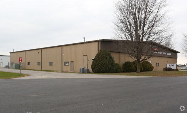
112 Maple Ct
Rochelle, IL
LOTS 8, 9 & 10 RESUB OF LOTS 4,5&6 HILLCREST INDUSTRIAL PARK VIL OF HILLCREST
24-12-177-013
Ogle
Commercialnec
Illinois
B and X Area of moderate flood hazard, usually the area between the limits of the 100-year and 500-year floods.
4-10
2025
3.62 AC
2025
I-39 Corridor/Ogle County
961200
Chicago
7,896 SF
NEARBY LISTINGS FOR SALE OR LEASE
DEMOGRAPHICS near 112 Maple Ct
1 mile
3 mile
5 mile
2025 Total Population
1,236
9,951
13,545
2030 Population
1,215
9,908
13,474
Pop Growth 2025-2030
(1.70%)
(0.43%)
(0.52%)
Average Age
38
40
39
2025 Total Households
419
3,955
5,300
HH Growth 2025-2030
(1.91%)
(0.46%)
(0.53%)
Median Household Inc
$79,076
$71,751
$72,140
Avg Household Size
3.00
2.50
2.50
2025 Avg HH Vehicles
2.00
2.00
2.00
Median Home Value
$165,568
$173,091
$176,941
Median Year Built
1977
1970
1971
Nearby Places
Map Layers
Map Styles
 Street
 Aerial
Layers
 Traffic
 Biking
Places
Listings with unknown addresses are not visible on the map
- Restaurants
- Banks
- Shops
- Fitness
- Groceries
PUBLIC TRANSPORTATION
AIRPORT
Chicago/Rockford International
Drive
Walk
Distance
Chicago/Rockford International
28 min
17.6 mi
Freight Ports
Port Milwaukee
Drive
Walk
Distance
Port Milwaukee
134 min
114.7 mi
Nearby Properties
Address
Land Use
TOTAL SIZE
Lot Size
Zoning
Address
Land Use
TOTAL SIZE
Lot Size
Zoning
Address
Land Use
TOTAL SIZE
Lot Size
Zoning
39,403 SF
13.64 AC
Address
Land Use
TOTAL SIZE
Lot Size
Zoning
Address
Land Use
TOTAL SIZE
Lot Size
Zoning
14.13 AC
Address
Land Use
TOTAL SIZE
Lot Size
Zoning
25.19 AC
Address
Land Use
TOTAL SIZE
Lot Size
Zoning
55.67 AC
Address
Land Use
TOTAL SIZE
Lot Size
Zoning
2.64 AC
Address
Land Use
TOTAL SIZE
Lot Size
Zoning
58,473 SF
2.13 AC
Address
Land Use
TOTAL SIZE
Lot Size
Zoning
21,000 SF
4.81 AC
Address
Land Use
TOTAL SIZE
Lot Size
Zoning
55,200 SF
1.74 AC
Address
Land Use
TOTAL SIZE
Lot Size
Zoning
1.27 AC
Address
Land Use
TOTAL SIZE
Lot Size
Zoning
1.15 AC
Address
Land Use
TOTAL SIZE
Lot Size
Zoning
1.85 AC
Address
Land Use
TOTAL SIZE
Lot Size
Zoning
5.85 AC
Address
Land Use
TOTAL SIZE
Lot Size
Zoning
2.38 AC
Address
Land Use
TOTAL SIZE
Lot Size
Zoning
95,734 SF
5.90 AC
Address
Land Use
TOTAL SIZE
Lot Size
Zoning
69,602 SF
2.84 AC
Address
Land Use
TOTAL SIZE
Lot Size
Zoning
59,932 SF
4.33 AC
Address
Land Use
TOTAL SIZE
Lot Size
Zoning
47,040 SF
2.26 AC
Address
Land Use
TOTAL SIZE
Lot Size
Zoning
8.64 AC
Address
Land Use
TOTAL SIZE
Lot Size
Zoning
6.85 AC
Address
Land Use
TOTAL SIZE
Lot Size
Zoning
17,868 SF
4.01 AC
Address
Land Use
TOTAL SIZE
Lot Size
Zoning
7,839 SF
0.19 AC
Address
Land Use
TOTAL SIZE
Lot Size
Zoning
1.50 AC
Address
Land Use
TOTAL SIZE
Lot Size
Zoning
6,080 SF
2.52 AC
Address
Land Use
TOTAL SIZE
Lot Size
Zoning
14,800 SF
1.18 AC
Address
Land Use
TOTAL SIZE
Lot Size
Zoning
62,259 SF
8.52 AC
The World's #1 Commercial Real Estate Marketplace
Connect with us
© 2026 CoStar Group
The information above has been obtained from sources believed reliable. While we do not doubt its accuracy we have not verified it and make no guarantee, warranty or representation about it. It is your responsibility to independently confirm its accuracy and completeness. Any projections, opinions, assumptions, or estimates used are for example only and do not represent the current or future performance of the property. The value of this transaction to you depends on tax and other factors which should be evaluated by your tax, financial, and legal advisors. You and your advisors should conduct a careful, independent investigation of the property to determine to your satisfaction the suitability of the property for your needs.