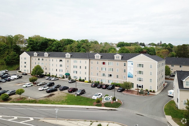
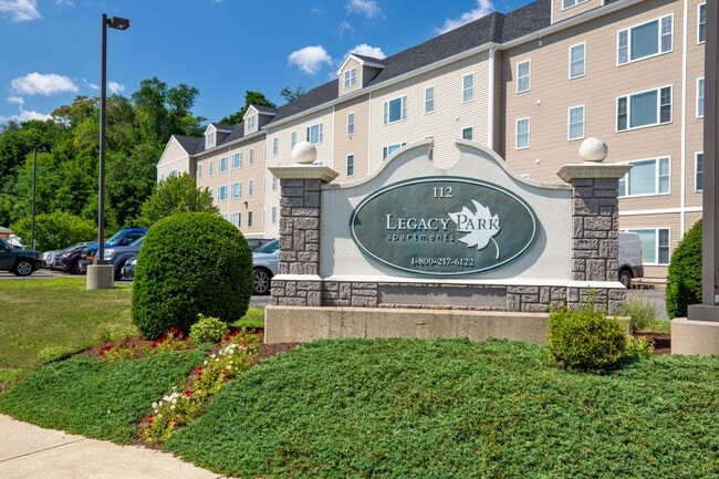
Property Record
112 Marston St, Lawrence, MA 01841


Property Detail
112 Marston St
LAWR-000030-000000-000038
ESSEX
Apartment
Massachusetts
B and X Area of moderate flood hazard, usually the area between the limits of the 100-year and 500-year floods.
38
2025
2.38 AC
2025
North Lawrence
250800
Boston
77,320 SF
Boston-Cambridge-Newton, MA-NH
NEARBY LISTINGS FOR SALE OR LEASE
DEMOGRAPHICS near 112 Marston St
1 mile
3 mile
5 mile
2025 Total Population
25,826
138,762
214,487
2030 Population
26,202
139,792
217,391
Pop Growth 2025-2030
+ 1.46%
+ 0.74%
+ 1.35%
Average Age
37
38
39
2025 Total Households
8,720
48,165
76,041
HH Growth 2025-2030
+ 1.80%
+ 0.96%
+ 1.48%
Median Household Inc
$65,359
$73,178
$86,886
Avg Household Size
2.70
2.70
2.70
2025 Avg HH Vehicles
1.00
2.00
2.00
Median Home Value
$447,755
$469,480
$536,366
Median Year Built
1953
1957
1964
Nearby Places
Map Layers
Map Styles
 Street
 Aerial
Layers
 Traffic
 Biking
Places
Listings with unknown addresses are not visible on the map
- Restaurants
- Banks
- Shops
- Fitness
- Groceries
PUBLIC TRANSPORTATION
COMMUTER RAIL
Lawrence (Haverhill Line - Massachusetts Bay Transportation Authority Commuter Rail (Purple Line))
Drive
Walk
Distance
Lawrence (Haverhill Line - Massachusetts Bay Transportation Authority Commuter Rail (Purple Line))
4 min
1.4 mi
Andover (Haverhill Line - Massachusetts Bay Transportation Authority Commuter Rail (Purple Line))
Drive
Walk
Distance
Andover (Haverhill Line - Massachusetts Bay Transportation Authority Commuter Rail (Purple Line))
10 min
4.6 mi
AIRPORT
Manchester Boston Regional
Drive
Walk
Distance
Manchester Boston Regional
45 min
27.5 mi
General Edward Lawrence Logan International
Drive
Walk
Distance
General Edward Lawrence Logan International
44 min
31.4 mi
Portsmouth International at Pease
Drive
Walk
Distance
Portsmouth International at Pease
50 min
37.3 mi
Nearby Properties
Address
Land Use
TOTAL SIZE
Lot Size
Zoning
Address
Land Use
TOTAL SIZE
Lot Size
Zoning
110.12 AC
I2
Address
Land Use
TOTAL SIZE
Lot Size
Zoning
25.50 AC
IA
Address
Land Use
TOTAL SIZE
Lot Size
Zoning
6,680 SF
84.07 AC
R2
Address
Land Use
TOTAL SIZE
Lot Size
Zoning
395,328 SF
49.52 AC
CN
Address
Land Use
TOTAL SIZE
Lot Size
Zoning
347,539 SF
45.99 AC
BH
Address
Land Use
TOTAL SIZE
Lot Size
Zoning
10.38 AC
Address
Land Use
TOTAL SIZE
Lot Size
Zoning
3,111 SF
42.18 AC
R5
Address
Land Use
TOTAL SIZE
Lot Size
Zoning
3,000 SF
44.13 AC
IL
Address
Land Use
TOTAL SIZE
Lot Size
Zoning
9.28 AC
I2
Address
Land Use
TOTAL SIZE
Lot Size
Zoning
9,966 SF
67.03 AC
R2
Address
Land Use
TOTAL SIZE
Lot Size
Zoning
204,300 SF
5.48 AC
Address
Land Use
TOTAL SIZE
Lot Size
Zoning
335,482 SF
7.61 AC
Address
Land Use
TOTAL SIZE
Lot Size
Zoning
240,639 SF
2.65 AC
Address
Land Use
TOTAL SIZE
Lot Size
Zoning
22.55 AC
IA
Address
Land Use
TOTAL SIZE
Lot Size
Zoning
16.56 AC
Address
Land Use
TOTAL SIZE
Lot Size
Zoning
170,116 SF
11.14 AC
Address
Land Use
TOTAL SIZE
Lot Size
Zoning
472,045 SF
72.30 AC
HD
Address
Land Use
TOTAL SIZE
Lot Size
Zoning
184,307 SF
7.87 AC
BH
Address
Land Use
TOTAL SIZE
Lot Size
Zoning
8.59 AC
IS
Address
Land Use
TOTAL SIZE
Lot Size
Zoning
71,785 SF
29 AC
R4
Address
Land Use
TOTAL SIZE
Lot Size
Zoning
332,500 SF
3.17 AC
Address
Land Use
TOTAL SIZE
Lot Size
Zoning
7.13 AC
Address
Land Use
TOTAL SIZE
Lot Size
Zoning
8,738 SF
30.59 AC
R4
Address
Land Use
TOTAL SIZE
Lot Size
Zoning
Address
Land Use
TOTAL SIZE
Lot Size
Zoning
208,600 SF
2.42 AC
Address
Land Use
TOTAL SIZE
Lot Size
Zoning
6.84 AC
Address
Land Use
TOTAL SIZE
Lot Size
Zoning
185,046 SF
3.06 AC
Address
Land Use
TOTAL SIZE
Lot Size
Zoning
2,552 SF
14.23 AC
Address
Land Use
TOTAL SIZE
Lot Size
Zoning
9,920 SF
3.24 AC
B2
Address
Land Use
TOTAL SIZE
Lot Size
Zoning
205,305 SF
1.94 AC
The World's #1 Commercial Real Estate Marketplace
Connect with us
© 2026 CoStar Group
The information above has been obtained from sources believed reliable. While we do not doubt its accuracy we have not verified it and make no guarantee, warranty or representation about it. It is your responsibility to independently confirm its accuracy and completeness. Any projections, opinions, assumptions, or estimates used are for example only and do not represent the current or future performance of the property. The value of this transaction to you depends on tax and other factors which should be evaluated by your tax, financial, and legal advisors. You and your advisors should conduct a careful, independent investigation of the property to determine to your satisfaction the suitability of the property for your needs.