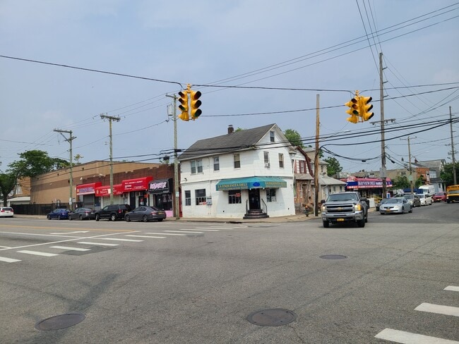
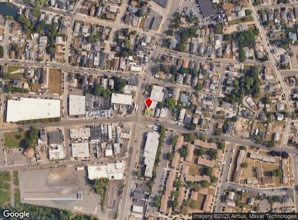
Property Record
112 Sheridan Blvd, Inwood, NY 11096

NEARBY LISTINGS FOR SALE OR LEASE
Property Detail
112 Sheridan Blvd
2089-40-087-00-0321-0
TOWN #1 SCH DIST 015
Commercialnec
Nassau
X
New York
36059C0282G
321
2025
0.02 AC
2025
Southern Nassau
411100
Long Island (New York)
2,780 SF
Nassau County-Suffolk County, NY
DEMOGRAPHICS near 112 Sheridan Blvd
1 Mile
3 Mile
5 Mile
2024 Total Population
36,730
139,441
368,881
2029 Population
34,757
132,587
348,985
Pop Growth 2024-2029
(5.37%)
(4.92%)
(5.39%)
Average Age
35
38
40
2024 Total Households
10,310
44,111
120,876
HH Growth 2024-2029
(5.61%)
(5.10%)
(5.53%)
Median Household Inc
$59,101
$70,706
$85,168
Avg Household Size
3.30
2.90
2.90
2024 Avg HH Vehicles
1.00
1.00
1.00
Median Home Value
$706,030
$744,999
$659,572
Median Year Built
1956
1962
1957
Nearby Places
- Restaurants
- Banks
- Shops
- Fitness
- Groceries
PUBLIC TRANSPORTATION
TRANSIT/SUBWAY
Inwood Station (Far Rockaway Branch - Long Island Rail Road)
DRIVE
WALK
Distance
Inwood Station (Far Rockaway Branch - Long Island Rail Road)
2 min
12 min
0.6 mi
Far Rockaway Station (Far Rockaway Branch - Long Island Rail Road)
DRIVE
WALK
Distance
Far Rockaway Station (Far Rockaway Branch - Long Island Rail Road)
2 min
12 min
0.6 mi
Far Rockaway-Mott Avenue (A - New York MTA Subway (The Subway))
DRIVE
WALK
Distance
Far Rockaway-Mott Avenue (A - New York MTA Subway (The Subway))
2 min
15 min
0.8 mi
Lawrence Station (Far Rockaway Branch - Long Island Rail Road)
DRIVE
WALK
Distance
Lawrence Station (Far Rockaway Branch - Long Island Rail Road)
2 min
17 min
0.9 mi
COMMUTER RAIL
Inwood Station (Far Rockaway Branch - Long Island Rail Road)
DRIVE
WALK
Distance
Inwood Station (Far Rockaway Branch - Long Island Rail Road)
2 min
11 min
0.6 mi
Far Rockaway Station (Far Rockaway Branch - Long Island Rail Road)
DRIVE
WALK
Distance
Far Rockaway Station (Far Rockaway Branch - Long Island Rail Road)
2 min
12 min
0.6 mi
AIRPORT
John F Kennedy International
DRIVE
WALK
Distance
John F Kennedy International
17 min
7.9 mi
LaGuardia
DRIVE
WALK
Distance
LaGuardia
27 min
14.9 mi
Newark Liberty International
DRIVE
WALK
Distance
Newark Liberty International
55 min
34.7 mi
Freight Ports
NY - Red Hook Container Terminal
DRIVE
WALK
Distance
NY - Red Hook Container Terminal
37 min
19.1 mi
SALE & LEASE HISTORY
LISTING DATE
SALE/LEASE

Aug 05, 2021
For Lease
Nearby Properties
Address
Land Use
TOTAL SIZE
Lot Size
Zoning
Address
Land Use
TOTAL SIZE
Lot Size
Zoning
14,417,607 SF
4,921.45 AC
M1-1
Address
Land Use
TOTAL SIZE
Lot Size
Zoning
229.51 AC
PARKUS
Address
Land Use
TOTAL SIZE
Lot Size
Zoning
111.98 AC
PARK
Address
Land Use
TOTAL SIZE
Lot Size
Zoning
182.50 AC
M1-1
Address
Land Use
TOTAL SIZE
Lot Size
Zoning
72,663 SF
264.48 AC
PARK
Address
Land Use
TOTAL SIZE
Lot Size
Zoning
124.60 AC
M1-1
Address
Land Use
TOTAL SIZE
Lot Size
Zoning
294.47 AC
PARK
Address
Land Use
TOTAL SIZE
Lot Size
Zoning
169.01 AC
PARK
Address
Land Use
TOTAL SIZE
Lot Size
Zoning
1,085,148 SF
13.53 AC
R6
Address
Land Use
TOTAL SIZE
Lot Size
Zoning
52.80 AC
PARK
Address
Land Use
TOTAL SIZE
Lot Size
Zoning
32.47 AC
PARK
Address
Land Use
TOTAL SIZE
Lot Size
Zoning
188,656 SF
5.78 AC
R5
Address
Land Use
TOTAL SIZE
Lot Size
Zoning
820,910 SF
21.03 AC
R4
Address
Land Use
TOTAL SIZE
Lot Size
Zoning
188.92 AC
PARK
Address
Land Use
TOTAL SIZE
Lot Size
Zoning
27.23 AC
PARK
Address
Land Use
TOTAL SIZE
Lot Size
Zoning
661,319 SF
50.43 AC
R5
Address
Land Use
TOTAL SIZE
Lot Size
Zoning
93.35 AC
PARK
Address
Land Use
TOTAL SIZE
Lot Size
Zoning
587,170 SF
13.55 AC
R4
Address
Land Use
TOTAL SIZE
Lot Size
Zoning
14.91 AC
C4-4
Address
Land Use
TOTAL SIZE
Lot Size
Zoning
154,051 SF
4.05 AC
R5
Address
Land Use
TOTAL SIZE
Lot Size
Zoning
119,788 SF
3.90 AC
R5
Address
Land Use
TOTAL SIZE
Lot Size
Zoning
178,870 SF
7.60 AC
M1-1
Address
Land Use
TOTAL SIZE
Lot Size
Zoning
213,338 SF
2.91 AC
R3X
Address
Land Use
TOTAL SIZE
Lot Size
Zoning
449,000 SF
5.15 AC
R6
Address
Land Use
TOTAL SIZE
Lot Size
Zoning
128,000 SF
2.52 AC
R5
Address
Land Use
TOTAL SIZE
Lot Size
Zoning
155,875 SF
0.90 AC
R6
Address
Land Use
TOTAL SIZE
Lot Size
Zoning
145,883 SF
1.29 AC
R6
Address
Land Use
TOTAL SIZE
Lot Size
Zoning
120,994 SF
1.71 AC
R6
Address
Land Use
TOTAL SIZE
Lot Size
Zoning
6,077 SF
19.66 AC
PARK
Address
Land Use
TOTAL SIZE
Lot Size
Zoning
358,140 SF
8.13 AC
R5
The World's #1 Commercial Real Estate Marketplace
Connect with us
© 2025 CoStar Group
The information above has been obtained from sources believed reliable. While we do not doubt its accuracy we have not verified it and make no guarantee, warranty or representation about it. It is your responsibility to independently confirm its accuracy and completeness. Any projections, opinions, assumptions, or estimates used are for example only and do not represent the current or future performance of the property. The value of this transaction to you depends on tax and other factors which should be evaluated by your tax, financial, and legal advisors. You and your advisors should conduct a careful, independent investigation of the property to determine to your satisfaction the suitability of the property for your needs.