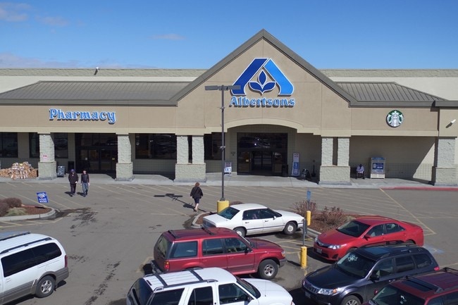
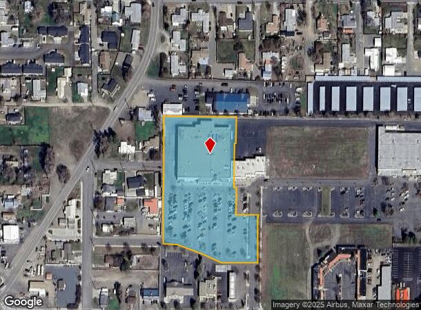
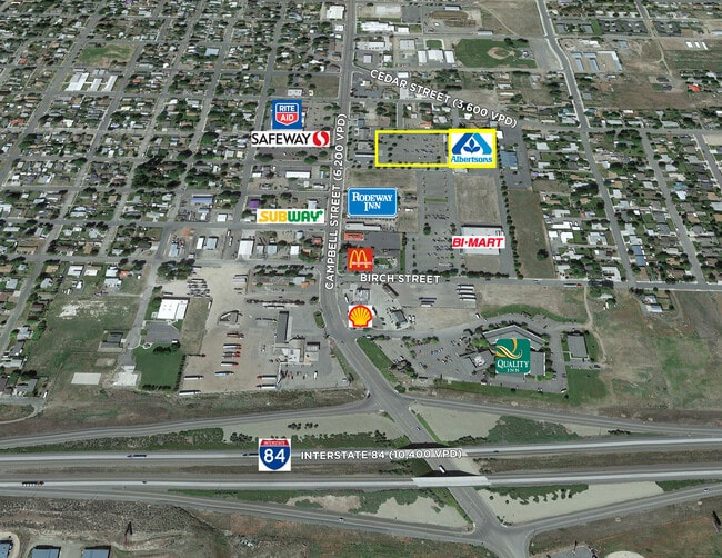
Property Record
1120 Campbell St, Baker City, OR 97814

NEARBY LISTINGS FOR SALE OR LEASE
Property Detail
1120 Campbell St
Other Market Areas
Baker Towne Square
017364
SUPERMARKET
Commercialnec
Baker
2025
Oregon
2025
1
950400
4.07 AC
43,870 SF
Oregon East Area
DEMOGRAPHICS near 1120 Campbell St
1 Mile
3 Mile
5 Mile
2024 Total Population
5,514
10,561
10,854
2029 Population
5,779
11,082
11,391
Pop Growth 2024-2029
+ 4.81%
+ 4.93%
+ 4.95%
Average Age
44
44
44
2024 Total Households
2,455
4,510
4,632
HH Growth 2024-2029
+ 4.85%
+ 4.99%
+ 5.01%
Median Household Inc
$52,883
$50,337
$50,728
Avg Household Size
2.20
2.20
2.20
2024 Avg HH Vehicles
2.00
2.00
2.00
Median Home Value
$216,620
$220,926
$223,789
Median Year Built
1957
1963
1963
Nearby Places
Map Layers
Map Styles
 Street
 Aerial
- Restaurants
- Banks
- Shops
- Fitness
- Groceries
SALE & LEASE HISTORY
LISTING DATE
SALE/LEASE

May 15, 2019
For Sale
Jun 01, 2020
For Sale
Apr 07, 2017
For Sale
Nearby Properties
Address
Land Use
TOTAL SIZE
Lot Size
Zoning
Address
Land Use
TOTAL SIZE
Lot Size
Zoning
132,651 SF
17.97 AC
CG
Address
Land Use
TOTAL SIZE
Lot Size
Zoning
60,872 SF
9.21 AC
CG
Address
Land Use
TOTAL SIZE
Lot Size
Zoning
170,274 SF
18.88 AC
RMD
Address
Land Use
TOTAL SIZE
Lot Size
Zoning
0.10 AC
I
Address
Land Use
TOTAL SIZE
Lot Size
Zoning
10.92 AC
I
Address
Land Use
TOTAL SIZE
Lot Size
Zoning
41,106 SF
3.96 AC
CG
Address
Land Use
TOTAL SIZE
Lot Size
Zoning
33,830 SF
11.36 AC
I
Address
Land Use
TOTAL SIZE
Lot Size
Zoning
43,527 SF
0.15 AC
BHD
Address
Land Use
TOTAL SIZE
Lot Size
Zoning
3.91 AC
CG
Address
Land Use
TOTAL SIZE
Lot Size
Zoning
79,254 SF
9.12 AC
CG
Address
Land Use
TOTAL SIZE
Lot Size
Zoning
46,462 SF
7.13 AC
RLD
Address
Land Use
TOTAL SIZE
Lot Size
Zoning
22,676 SF
0.68 AC
RHD
Address
Land Use
TOTAL SIZE
Lot Size
Zoning
3.22 AC
I
Address
Land Use
TOTAL SIZE
Lot Size
Zoning
18,564 SF
1.12 AC
CG
Address
Land Use
TOTAL SIZE
Lot Size
Zoning
10,203 SF
59.94 AC
RLD
Address
Land Use
TOTAL SIZE
Lot Size
Zoning
36,378 SF
4.12 AC
RMD
Address
Land Use
TOTAL SIZE
Lot Size
Zoning
14,533 SF
1.97 AC
CG
Address
Land Use
TOTAL SIZE
Lot Size
Zoning
5,177 SF
12.06 AC
RR5
Address
Land Use
TOTAL SIZE
Lot Size
Zoning
17,997 SF
0.57 AC
BHD
Address
Land Use
TOTAL SIZE
Lot Size
Zoning
44,821 SF
5.52 AC
RMD
Address
Land Use
TOTAL SIZE
Lot Size
Zoning
25,986 SF
3.39 AC
CG
Address
Land Use
TOTAL SIZE
Lot Size
Zoning
19,918 SF
3 AC
RMD
Address
Land Use
TOTAL SIZE
Lot Size
Zoning
71,952 SF
1.31 AC
BHD
Address
Land Use
TOTAL SIZE
Lot Size
Zoning
32,684 SF
2.32 AC
RHD
Address
Land Use
TOTAL SIZE
Lot Size
Zoning
21,048 SF
0.36 AC
BHD
Address
Land Use
TOTAL SIZE
Lot Size
Zoning
14,655 SF
4.50 AC
RMD
Address
Land Use
TOTAL SIZE
Lot Size
Zoning
5,795 SF
1.44 AC
RHD
Address
Land Use
TOTAL SIZE
Lot Size
Zoning
23,430 SF
3.89 AC
RLD
Address
Land Use
TOTAL SIZE
Lot Size
Zoning
72 SF
1.08 AC
CG
The World's #1 Commercial Real Estate Marketplace
Connect with us
© 2026 CoStar Group
The information above has been obtained from sources believed reliable. While we do not doubt its accuracy we have not verified it and make no guarantee, warranty or representation about it. It is your responsibility to independently confirm its accuracy and completeness. Any projections, opinions, assumptions, or estimates used are for example only and do not represent the current or future performance of the property. The value of this transaction to you depends on tax and other factors which should be evaluated by your tax, financial, and legal advisors. You and your advisors should conduct a careful, independent investigation of the property to determine to your satisfaction the suitability of the property for your needs.