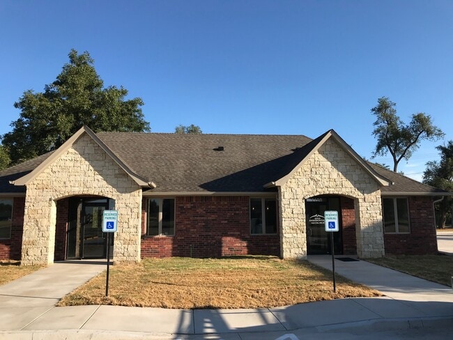
Property Record
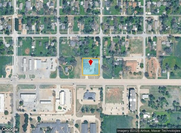
1120 E Owen K Garriott Rd, Enid, OK 73701
NEARBY LISTINGS FOR SALE OR LEASE
-
-
-
No Photo
-
-
-
-
-
View all Enid listings for lease on LoopNet.com
Property Detail
1120 E Owen K Garriott Rd
Enid, OK
Rosedale Addition
4260-00-017-026-0-257-00
LOT 26-32 BLOCK 17 SD-E57 ROSEDALE ADDN SE/4 8-22-6 COMB L26-32 TO PUT ALL IMPR ON SAME PARCEL 8-22
Medicalbuilding
Garfield
X
Oklahoma
40047C0215E
26-32
2024
3 AC
2025
Oklahoma West Area
000702
Other Market Areas
2,560 SF
DEMOGRAPHICS near 1120 E Owen K Garriott Rd
1 Mile
3 Mile
5 Mile
2024 Total Population
7,827
33,238
51,547
2029 Population
7,869
32,993
50,771
Pop Growth 2024-2029
+ 0.54%
(0.74%)
(1.51%)
Average Age
34
36
38
2024 Total Households
2,698
12,483
19,880
HH Growth 2024-2029
+ 0.59%
(0.74%)
(1.56%)
Median Household Inc
$33,489
$47,907
$57,649
Avg Household Size
2.70
2.50
2.50
2024 Avg HH Vehicles
2.00
2.00
2.00
Median Home Value
$59,392
$92,433
$140,747
Median Year Built
1952
1958
1969
Nearby Places
Map Layers
Map Styles
 Street
 Aerial
- Restaurants
- Banks
- Shops
- Fitness
- Groceries
SALE & LEASE HISTORY
LISTING DATE
SALE/LEASE

Dec 28, 2021
For Lease
Dec 28, 2021
For Lease
Nearby Properties
Address
Land Use
TOTAL SIZE
Lot Size
Zoning
Address
Land Use
TOTAL SIZE
Lot Size
Zoning
16,445 SF
2.49 AC
Address
Land Use
TOTAL SIZE
Lot Size
Zoning
79,801 SF
3.26 AC
Address
Land Use
TOTAL SIZE
Lot Size
Zoning
2,760 SF
157.96 AC
NP
Address
Land Use
TOTAL SIZE
Lot Size
Zoning
40,172 SF
18.93 AC
Address
Land Use
TOTAL SIZE
Lot Size
Zoning
51,476 SF
160 AC
NP
Address
Land Use
TOTAL SIZE
Lot Size
Zoning
207,942 SF
2.07 AC
Address
Land Use
TOTAL SIZE
Lot Size
Zoning
132,603 SF
17.42 AC
Address
Land Use
TOTAL SIZE
Lot Size
Zoning
28,160 SF
2.68 AC
Address
Land Use
TOTAL SIZE
Lot Size
Zoning
169,463 SF
30 AC
Address
Land Use
TOTAL SIZE
Lot Size
Zoning
6,719 SF
24.54 AC
Address
Land Use
TOTAL SIZE
Lot Size
Zoning
87,513 SF
9.15 AC
Address
Land Use
TOTAL SIZE
Lot Size
Zoning
69,406 SF
2.10 AC
Address
Land Use
TOTAL SIZE
Lot Size
Zoning
40,206 SF
3.29 AC
Address
Land Use
TOTAL SIZE
Lot Size
Zoning
67,830 SF
2.94 AC
Address
Land Use
TOTAL SIZE
Lot Size
Zoning
70,020 SF
1.03 AC
Address
Land Use
TOTAL SIZE
Lot Size
Zoning
33,501 SF
2.59 AC
Address
Land Use
TOTAL SIZE
Lot Size
Zoning
80,209 SF
2.94 AC
Address
Land Use
TOTAL SIZE
Lot Size
Zoning
61,567 SF
34 AC
Address
Land Use
TOTAL SIZE
Lot Size
Zoning
75,287 SF
6.34 AC
Address
Land Use
TOTAL SIZE
Lot Size
Zoning
58,909 SF
5.17 AC
Address
Land Use
TOTAL SIZE
Lot Size
Zoning
46,653 SF
2.20 AC
Address
Land Use
TOTAL SIZE
Lot Size
Zoning
51,174 SF
2.20 AC
Address
Land Use
TOTAL SIZE
Lot Size
Zoning
71,732 SF
3.33 AC
Address
Land Use
TOTAL SIZE
Lot Size
Zoning
33,831 SF
1.33 AC
Address
Land Use
TOTAL SIZE
Lot Size
Zoning
48,487 SF
1.03 AC
Address
Land Use
TOTAL SIZE
Lot Size
Zoning
44,764 SF
4.35 AC
Address
Land Use
TOTAL SIZE
Lot Size
Zoning
30,997 SF
5.97 AC
Address
Land Use
TOTAL SIZE
Lot Size
Zoning
14,076 SF
2.94 AC
Address
Land Use
TOTAL SIZE
Lot Size
Zoning
14,974 SF
1.89 AC
Address
Land Use
TOTAL SIZE
Lot Size
Zoning
46,421 SF
4.50 AC
The World's #1 Commercial Real Estate Marketplace
Connect with us
© 2025 CoStar Group
The information above has been obtained from sources believed reliable. While we do not doubt its accuracy we have not verified it and make no guarantee, warranty or representation about it. It is your responsibility to independently confirm its accuracy and completeness. Any projections, opinions, assumptions, or estimates used are for example only and do not represent the current or future performance of the property. The value of this transaction to you depends on tax and other factors which should be evaluated by your tax, financial, and legal advisors. You and your advisors should conduct a careful, independent investigation of the property to determine to your satisfaction the suitability of the property for your needs.