Property Record
1120 E Peterson Rd, Grayslake, IL 60030
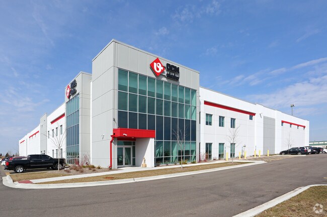

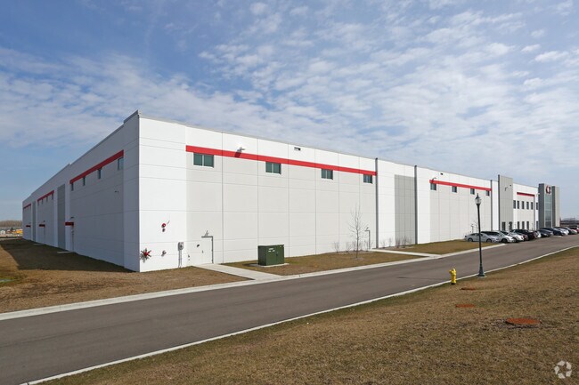
Property Detail
1120 E Peterson Rd
10-12-100-025
PT S1/2 NW1/4; LYG S OF N 470, W OF W LN MIDLOTHIAN RD & N OF N LN PETERSON RD SECTION 12 TOWNSHIP 44 RANGE 10
Industrialgeneral
LAKE
B and X Area of moderate flood hazard, usually the area between the limits of the 100-year and 500-year floods.
Illinois
2024
22.05 AC
2025
North Lake County
864110
Chicago
339,666 SF
Chicago-Naperville-Elgin, IL-IN
NEARBY LISTINGS FOR SALE OR LEASE
DEMOGRAPHICS near 1120 E Peterson Rd
1 mile
3 mile
5 mile
2025 Total Population
965
35,063
129,906
2030 Population
968
35,433
131,002
Pop Growth 2025-2030
+ 0.31%
+ 1.06%
+ 0.84%
Average Age
42
43
41
2025 Total Households
334
13,483
47,064
HH Growth 2025-2030
+ 0.30%
+ 1.13%
+ 0.84%
Median Household Inc
$130,482
$109,833
$117,979
Avg Household Size
2.90
2.50
2.70
2025 Avg HH Vehicles
2.00
2.00
2.00
Median Home Value
$421,296
$328,162
$342,737
Median Year Built
1996
1990
1988
Nearby Places
Map Layers
Map Styles
 Street
 Aerial
Layers
 Traffic
 Biking
Places
Listings with unknown addresses are not visible on the map
- Restaurants
- Banks
- Shops
- Fitness
- Groceries
PUBLIC TRANSPORTATION
COMMUTER RAIL
Prairie Crossing Station (NCS) (North Central Service - Northeast Illinois Regional Commuter Railroad (Metra))
Drive
Walk
Distance
Prairie Crossing Station (NCS) (North Central Service - Northeast Illinois Regional Commuter Railroad (Metra))
5 min
1.7 mi
Prairie Crossing Station (MD-North) (Milwaukee District North Line - Northeast Illinois Regional Commuter Railroad (Metra))
Drive
Walk
Distance
Prairie Crossing Station (MD-North) (Milwaukee District North Line - Northeast Illinois Regional Commuter Railroad (Metra))
4 min
1.7 mi
AIRPORT
Chicago O'Hare International
Drive
Walk
Distance
Chicago O'Hare International
45 min
31.2 mi
Nearby Properties
Address
Land Use
TOTAL SIZE
Lot Size
Zoning
Address
Land Use
TOTAL SIZE
Lot Size
Zoning
1,401,971 SF
85.78 AC
Address
Land Use
TOTAL SIZE
Lot Size
Zoning
Address
Land Use
TOTAL SIZE
Lot Size
Zoning
1.29 AC
Address
Land Use
TOTAL SIZE
Lot Size
Zoning
596,712 SF
35.56 AC
Address
Land Use
TOTAL SIZE
Lot Size
Zoning
2,993,760 SF
20.63 AC
Address
Land Use
TOTAL SIZE
Lot Size
Zoning
Address
Land Use
TOTAL SIZE
Lot Size
Zoning
298,181 SF
20.41 AC
Address
Land Use
TOTAL SIZE
Lot Size
Zoning
340,535 SF
19.01 AC
Address
Land Use
TOTAL SIZE
Lot Size
Zoning
Address
Land Use
TOTAL SIZE
Lot Size
Zoning
177,993 SF
10 AC
Address
Land Use
TOTAL SIZE
Lot Size
Zoning
786,312 SF
14.74 AC
Address
Land Use
TOTAL SIZE
Lot Size
Zoning
Address
Land Use
TOTAL SIZE
Lot Size
Zoning
217,620 SF
13.07 AC
Address
Land Use
TOTAL SIZE
Lot Size
Zoning
192,330 SF
10.23 AC
Address
Land Use
TOTAL SIZE
Lot Size
Zoning
Address
Land Use
TOTAL SIZE
Lot Size
Zoning
175,833 SF
7.70 AC
Address
Land Use
TOTAL SIZE
Lot Size
Zoning
175,818 SF
18 AC
Address
Land Use
TOTAL SIZE
Lot Size
Zoning
49.21 AC
Address
Land Use
TOTAL SIZE
Lot Size
Zoning
308,160 SF
7.43 AC
Address
Land Use
TOTAL SIZE
Lot Size
Zoning
282,999 SF
23.06 AC
Address
Land Use
TOTAL SIZE
Lot Size
Zoning
12.81 AC
Address
Land Use
TOTAL SIZE
Lot Size
Zoning
Address
Land Use
TOTAL SIZE
Lot Size
Zoning
428,703 SF
24.63 AC
Address
Land Use
TOTAL SIZE
Lot Size
Zoning
100,123 SF
12.63 AC
Address
Land Use
TOTAL SIZE
Lot Size
Zoning
Address
Land Use
TOTAL SIZE
Lot Size
Zoning
Address
Land Use
TOTAL SIZE
Lot Size
Zoning
95,180 SF
12.40 AC
Address
Land Use
TOTAL SIZE
Lot Size
Zoning
71,320 SF
26.33 AC
Address
Land Use
TOTAL SIZE
Lot Size
Zoning
The World's #1 Commercial Real Estate Marketplace
Connect with us
© 2026 CoStar Group
The information above has been obtained from sources believed reliable. While we do not doubt its accuracy we have not verified it and make no guarantee, warranty or representation about it. It is your responsibility to independently confirm its accuracy and completeness. Any projections, opinions, assumptions, or estimates used are for example only and do not represent the current or future performance of the property. The value of this transaction to you depends on tax and other factors which should be evaluated by your tax, financial, and legal advisors. You and your advisors should conduct a careful, independent investigation of the property to determine to your satisfaction the suitability of the property for your needs.