Property Record
1120 Vine St, Noblesville, IN 46060
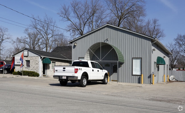


This Property Is For Sale
NEARBY LISTINGS FOR SALE OR LEASE
Property Detail
1120 Vine St
Indianapolis-Carmel-Greenwood, IN
W A Emmons 2Nd Section 7
29-11-06-104-036.000-013
ACREAGE 1.13, SECTION 6, TOWNSHIP 18, RANGE 5, W A EMMONS 2ND, SECTION 7, LOT 1, ADDITIONAL LEGAL DESCRIPTION: A B COLE PT LOT 3 & RAILROAD PARCEL CONRAIL
Storebuilding
Hamilton
X
Indiana
18057C0142H
1
2023
1.13 AC
2024
Far North Hamilton Cnty
110700
Indianapolis
2,712 SF
DEMOGRAPHICS near 1120 Vine St
1 Mile
3 Mile
5 Mile
2024 Total Population
7,791
41,896
120,504
2029 Population
8,821
47,239
135,530
Pop Growth 2024-2029
+ 13.22%
+ 12.75%
+ 12.47%
Average Age
39
39
38
2024 Total Households
3,304
15,706
43,957
HH Growth 2024-2029
+ 13.14%
+ 12.76%
+ 12.48%
Median Household Inc
$50,026
$84,648
$94,758
Avg Household Size
2.30
2.60
2.70
2024 Avg HH Vehicles
2.00
2.00
2.00
Median Home Value
$176,539
$264,839
$289,107
Median Year Built
1955
1999
2002
Nearby Places
Map Layers
Map Styles
 Street
 Aerial
- Restaurants
- Banks
- Shops
- Fitness
- Groceries
PUBLIC TRANSPORTATION
AIRPORT
Indianapolis International
DRIVE
WALK
Distance
Indianapolis International
61 min
37.1 mi
Nearby Properties
Address
Land Use
TOTAL SIZE
Lot Size
Zoning
Address
Land Use
TOTAL SIZE
Lot Size
Zoning
517,873 SF
15.83 AC
Address
Land Use
TOTAL SIZE
Lot Size
Zoning
450,420 SF
24.54 AC
Address
Land Use
TOTAL SIZE
Lot Size
Zoning
1,395,736 SF
77.82 AC
Address
Land Use
TOTAL SIZE
Lot Size
Zoning
1,008,279 SF
60.59 AC
Address
Land Use
TOTAL SIZE
Lot Size
Zoning
480,315 SF
21.53 AC
Address
Land Use
TOTAL SIZE
Lot Size
Zoning
317,049 SF
38.45 AC
Address
Land Use
TOTAL SIZE
Lot Size
Zoning
212,035 SF
4.42 AC
Address
Land Use
TOTAL SIZE
Lot Size
Zoning
346,059 SF
7.88 AC
Address
Land Use
TOTAL SIZE
Lot Size
Zoning
271,049 SF
15.44 AC
Address
Land Use
TOTAL SIZE
Lot Size
Zoning
279,101 SF
14.95 AC
Address
Land Use
TOTAL SIZE
Lot Size
Zoning
224,086 SF
17.81 AC
Address
Land Use
TOTAL SIZE
Lot Size
Zoning
275,764 SF
14.88 AC
Address
Land Use
TOTAL SIZE
Lot Size
Zoning
214,828 SF
21.10 AC
Address
Land Use
TOTAL SIZE
Lot Size
Zoning
152,767 SF
21.92 AC
Address
Land Use
TOTAL SIZE
Lot Size
Zoning
229,136 SF
30.77 AC
Address
Land Use
TOTAL SIZE
Lot Size
Zoning
204,167 SF
14 AC
Address
Land Use
TOTAL SIZE
Lot Size
Zoning
127,664 SF
11.47 AC
Address
Land Use
TOTAL SIZE
Lot Size
Zoning
247,344 SF
16.02 AC
Address
Land Use
TOTAL SIZE
Lot Size
Zoning
108,805 SF
7 AC
Address
Land Use
TOTAL SIZE
Lot Size
Zoning
162,420 SF
14.02 AC
Address
Land Use
TOTAL SIZE
Lot Size
Zoning
132,260 SF
9.91 AC
Address
Land Use
TOTAL SIZE
Lot Size
Zoning
154,430 SF
12.28 AC
Address
Land Use
TOTAL SIZE
Lot Size
Zoning
110,986 SF
12.28 AC
Address
Land Use
TOTAL SIZE
Lot Size
Zoning
216,122 SF
17.70 AC
Address
Land Use
TOTAL SIZE
Lot Size
Zoning
125,261 SF
0.94 AC
Address
Land Use
TOTAL SIZE
Lot Size
Zoning
104,873 SF
3.67 AC
Address
Land Use
TOTAL SIZE
Lot Size
Zoning
116,799 SF
4.63 AC
Address
Land Use
TOTAL SIZE
Lot Size
Zoning
209,236 SF
17.88 AC
Address
Land Use
TOTAL SIZE
Lot Size
Zoning
200,607 SF
18.78 AC
Address
Land Use
TOTAL SIZE
Lot Size
Zoning
133,924 SF
0.67 AC
The World's #1 Commercial Real Estate Marketplace
Connect with us
© 2026 CoStar Group
The information above has been obtained from sources believed reliable. While we do not doubt its accuracy we have not verified it and make no guarantee, warranty or representation about it. It is your responsibility to independently confirm its accuracy and completeness. Any projections, opinions, assumptions, or estimates used are for example only and do not represent the current or future performance of the property. The value of this transaction to you depends on tax and other factors which should be evaluated by your tax, financial, and legal advisors. You and your advisors should conduct a careful, independent investigation of the property to determine to your satisfaction the suitability of the property for your needs.