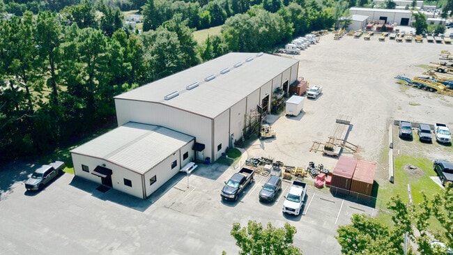
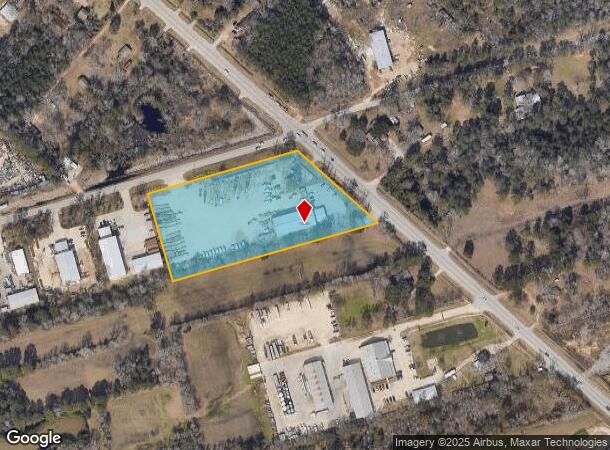
Property Record
1120 Fm 3083 Rd, Conroe, TX 77301

Current Lease Availabilities
NEARBY LISTINGS FOR SALE OR LEASE
Property Detail
1120 Fm 3083 Rd
2528-00-00100
Bdbf Business Park
Commercialnec
S252800 - BDBF BUSINESS PARK, BLOCK 1, RES A, ACRES 4.392
X
Montgomery
48339C0395G
Texas
2024
4.39 AC
2025
The Woodlands/Conroe
693102
Houston
9,960 SF
Houston-Pasadena-The Woodlands, TX
DEMOGRAPHICS near 1120 Fm 3083 Rd
1 Mile
3 Mile
5 Mile
2024 Total Population
1,028
27,586
80,086
2029 Population
1,259
33,920
98,263
Pop Growth 2024-2029
+ 22.47%
+ 22.96%
+ 22.70%
Average Age
36
35
36
2024 Total Households
340
8,498
27,067
HH Growth 2024-2029
+ 22.35%
+ 23.08%
+ 23.28%
Median Household Inc
$71,158
$62,909
$61,514
Avg Household Size
2.90
3.10
2.80
2024 Avg HH Vehicles
2.00
2.00
2.00
Median Home Value
$234,466
$183,124
$218,725
Median Year Built
2010
1999
1997
Nearby Places
Map Layers
Map Styles
 Street
 Aerial
- Restaurants
- Banks
- Shops
- Fitness
- Groceries
PUBLIC TRANSPORTATION
AIRPORT
George Bush Intcntl/Houston
DRIVE
WALK
Distance
George Bush Intcntl/Houston
42 min
33.7 mi
Freight Ports
Port of Houston
DRIVE
WALK
Distance
Port of Houston
65 min
49.4 mi
Nearby Properties
Address
Land Use
TOTAL SIZE
Lot Size
Zoning
Address
Land Use
TOTAL SIZE
Lot Size
Zoning
619,770 SF
81.76 AC
Address
Land Use
TOTAL SIZE
Lot Size
Zoning
326,478 SF
20.22 AC
Address
Land Use
TOTAL SIZE
Lot Size
Zoning
206,008 SF
107.61 AC
Address
Land Use
TOTAL SIZE
Lot Size
Zoning
242,944 SF
179.58 AC
Address
Land Use
TOTAL SIZE
Lot Size
Zoning
186,100 SF
29.68 AC
1
Address
Land Use
TOTAL SIZE
Lot Size
Zoning
82,078 SF
61.15 AC
1
Address
Land Use
TOTAL SIZE
Lot Size
Zoning
141,600 SF
15.02 AC
1
Address
Land Use
TOTAL SIZE
Lot Size
Zoning
262,564 SF
51.89 AC
1
Address
Land Use
TOTAL SIZE
Lot Size
Zoning
159,185 SF
18.45 AC
1
Address
Land Use
TOTAL SIZE
Lot Size
Zoning
117,392 SF
27 AC
1
Address
Land Use
TOTAL SIZE
Lot Size
Zoning
143,641 SF
14.80 AC
1
Address
Land Use
TOTAL SIZE
Lot Size
Zoning
161,142 SF
493.71 AC
Address
Land Use
TOTAL SIZE
Lot Size
Zoning
187,426 SF
61.77 AC
1
Address
Land Use
TOTAL SIZE
Lot Size
Zoning
35,026 SF
3.24 AC
Address
Land Use
TOTAL SIZE
Lot Size
Zoning
82,280 SF
9.60 AC
1
Address
Land Use
TOTAL SIZE
Lot Size
Zoning
70,912 SF
5.07 AC
1
Address
Land Use
TOTAL SIZE
Lot Size
Zoning
82,560 SF
1
Address
Land Use
TOTAL SIZE
Lot Size
Zoning
78,110 SF
14 AC
1
Address
Land Use
TOTAL SIZE
Lot Size
Zoning
155,890 SF
20 AC
Address
Land Use
TOTAL SIZE
Lot Size
Zoning
151,295 SF
10 AC
Address
Land Use
TOTAL SIZE
Lot Size
Zoning
63,366 SF
17.93 AC
1
Address
Land Use
TOTAL SIZE
Lot Size
Zoning
33,476 SF
7.24 AC
1
Address
Land Use
TOTAL SIZE
Lot Size
Zoning
132,252 SF
21.40 AC
1
Address
Land Use
TOTAL SIZE
Lot Size
Zoning
14,750 SF
1.66 AC
Address
Land Use
TOTAL SIZE
Lot Size
Zoning
44,182 SF
6.25 AC
1
Address
Land Use
TOTAL SIZE
Lot Size
Zoning
64,150 SF
6.41 AC
1
Address
Land Use
TOTAL SIZE
Lot Size
Zoning
58,772 SF
1.72 AC
1
Address
Land Use
TOTAL SIZE
Lot Size
Zoning
60,000 SF
5.02 AC
1
Address
Land Use
TOTAL SIZE
Lot Size
Zoning
Address
Land Use
TOTAL SIZE
Lot Size
Zoning
84,177 SF
4.74 AC
1
The World's #1 Commercial Real Estate Marketplace
Connect with us
© 2026 CoStar Group
The information above has been obtained from sources believed reliable. While we do not doubt its accuracy we have not verified it and make no guarantee, warranty or representation about it. It is your responsibility to independently confirm its accuracy and completeness. Any projections, opinions, assumptions, or estimates used are for example only and do not represent the current or future performance of the property. The value of this transaction to you depends on tax and other factors which should be evaluated by your tax, financial, and legal advisors. You and your advisors should conduct a careful, independent investigation of the property to determine to your satisfaction the suitability of the property for your needs.