Property Record
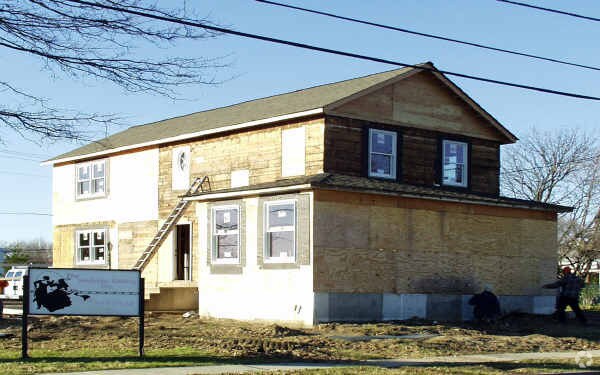
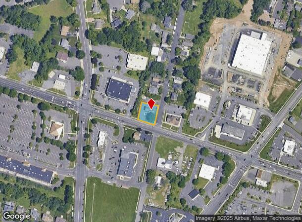
1120 Highway 33, Trenton, NJ 08690


This Property Is For Sale
NEARBY LISTINGS FOR SALE OR LEASE
-
-
-
-
No Photo
-
-
-
-
View all Trenton listings for sale on LoopNet.com
Property Detail
1120 Highway 33
03-01829-0000-00029
10002-
Commercialnec
Mercer
X
New Jersey
34021C0231F
29
2024
0.39 AC
2025
Trenton
003006
Northern New Jersey
2,331 SF
Trenton-Princeton, NJ
DEMOGRAPHICS near 1120 Highway 33
1 Mile
3 Mile
5 Mile
2024 Total Population
11,249
62,270
191,529
2029 Population
11,053
61,385
188,479
Pop Growth 2024-2029
(1.74%)
(1.42%)
(1.59%)
Average Age
45
44
40
2024 Total Households
4,261
25,312
68,377
HH Growth 2024-2029
(1.92%)
(1.58%)
(1.70%)
Median Household Inc
$113,873
$98,813
$84,695
Avg Household Size
2.60
2.40
2.70
2024 Avg HH Vehicles
2.00
2.00
2.00
Median Home Value
$312,790
$295,130
$278,990
Median Year Built
1965
1971
1961
Nearby Places
Map Layers
Map Styles
 Street
 Aerial
- Restaurants
- Banks
- Shops
- Fitness
- Groceries
PUBLIC TRANSPORTATION
COMMUTER RAIL
Hamilton (Northeast Corridor Line - NJ Transit Commuter Rail (NJ Transit))
DRIVE
WALK
Distance
Hamilton (Northeast Corridor Line - NJ Transit Commuter Rail (NJ Transit))
9 min
3.6 mi
Trenton Transit Center (NJT) (Northeast Corridor Line - NJ Transit Commuter Rail (NJ Transit), River LINE - River LINE (River LINE))
DRIVE
WALK
Distance
Trenton Transit Center (NJT) (Northeast Corridor Line - NJ Transit Commuter Rail (NJ Transit), River LINE - River LINE (River LINE))
12 min
5.3 mi
AIRPORT
Trenton Mercer
DRIVE
WALK
Distance
Trenton Mercer
21 min
13.4 mi
Philadelphia International
DRIVE
WALK
Distance
Philadelphia International
67 min
48.3 mi
Freight Ports
South Jersey Port
DRIVE
WALK
Distance
South Jersey Port
50 min
38.1 mi
Nearby Properties
Address
Land Use
TOTAL SIZE
Lot Size
Zoning
Address
Land Use
TOTAL SIZE
Lot Size
Zoning
40.83 AC
E
Address
Land Use
TOTAL SIZE
Lot Size
Zoning
Address
Land Use
TOTAL SIZE
Lot Size
Zoning
31.05 AC
Address
Land Use
TOTAL SIZE
Lot Size
Zoning
23.13 AC
RD
Address
Land Use
TOTAL SIZE
Lot Size
Zoning
30.94 AC
Address
Land Use
TOTAL SIZE
Lot Size
Zoning
60.26 AC
RD
Address
Land Use
TOTAL SIZE
Lot Size
Zoning
44.82 AC
RD
Address
Land Use
TOTAL SIZE
Lot Size
Zoning
2,030 SF
45.57 AC
Address
Land Use
TOTAL SIZE
Lot Size
Zoning
Address
Land Use
TOTAL SIZE
Lot Size
Zoning
18.33 AC
Address
Land Use
TOTAL SIZE
Lot Size
Zoning
17.84 AC
HC
Address
Land Use
TOTAL SIZE
Lot Size
Zoning
Address
Land Use
TOTAL SIZE
Lot Size
Zoning
23.13 AC
RR
Address
Land Use
TOTAL SIZE
Lot Size
Zoning
56.90 AC
RD
Address
Land Use
TOTAL SIZE
Lot Size
Zoning
44.83 AC
I
Address
Land Use
TOTAL SIZE
Lot Size
Zoning
50.05 AC
RR
Address
Land Use
TOTAL SIZE
Lot Size
Zoning
21.17 AC
I
Address
Land Use
TOTAL SIZE
Lot Size
Zoning
1,836 SF
33.91 AC
RD
Address
Land Use
TOTAL SIZE
Lot Size
Zoning
9.63 AC
RD
Address
Land Use
TOTAL SIZE
Lot Size
Zoning
27.50 AC
R7
Address
Land Use
TOTAL SIZE
Lot Size
Zoning
Address
Land Use
TOTAL SIZE
Lot Size
Zoning
Address
Land Use
TOTAL SIZE
Lot Size
Zoning
15.80 AC
C
Address
Land Use
TOTAL SIZE
Lot Size
Zoning
28.36 AC
E
Address
Land Use
TOTAL SIZE
Lot Size
Zoning
21.62 AC
RD
Address
Land Use
TOTAL SIZE
Lot Size
Zoning
Address
Land Use
TOTAL SIZE
Lot Size
Zoning
Address
Land Use
TOTAL SIZE
Lot Size
Zoning
Address
Land Use
TOTAL SIZE
Lot Size
Zoning
17,500 SF
18.14 AC
HC
Address
Land Use
TOTAL SIZE
Lot Size
Zoning
9.31 AC
HC
The World's #1 Commercial Real Estate Marketplace
Connect with us
© 2026 CoStar Group
The information above has been obtained from sources believed reliable. While we do not doubt its accuracy we have not verified it and make no guarantee, warranty or representation about it. It is your responsibility to independently confirm its accuracy and completeness. Any projections, opinions, assumptions, or estimates used are for example only and do not represent the current or future performance of the property. The value of this transaction to you depends on tax and other factors which should be evaluated by your tax, financial, and legal advisors. You and your advisors should conduct a careful, independent investigation of the property to determine to your satisfaction the suitability of the property for your needs.