No Photo
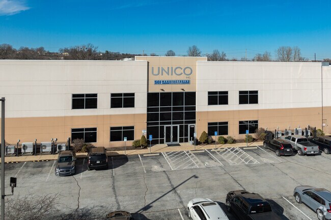
Property Record
1120 Intagliata Dr, Arnold, MO 63010

Property Detail
1120 Intagliata Dr
St. Louis, MO-IL
JK MILLER LOT 4
01-8.0-28.0-3-004-056
Jefferson
Industrialgeneral
Missouri
AE The base floodplain where base flood elevations are provided. AE Zones are now used on new format FIRMs instead of A1-A30 Zones.
4
2024
7.81 AC
2025
Jefferson County
700111
St. Louis
107,700 SF
NEARBY LISTINGS FOR SALE OR LEASE
-
-
-
No Photo
-
-
-
View all Arnold listings for sale on LoopNet.com
DEMOGRAPHICS near 1120 Intagliata Dr
1 mile
3 mile
5 mile
2025 Total Population
4,162
45,440
108,824
2030 Population
4,178
45,276
108,407
Pop Growth 2025-2030
+ 0.38%
(0.36%)
(0.38%)
Average Age
42
42
43
2025 Total Households
1,650
17,756
43,602
HH Growth 2025-2030
+ 0.55%
(0.28%)
(0.40%)
Median Household Inc
$80,841
$93,389
$92,693
Avg Household Size
2.50
2.50
2.50
2025 Avg HH Vehicles
2.00
2.00
2.00
Median Home Value
$225,288
$263,773
$282,034
Median Year Built
1977
1983
1982
Nearby Places
Map Layers
Map Styles
 Street
 Aerial
Layers
 Traffic
 Biking
Places
Listings with unknown addresses are not visible on the map
- Restaurants
- Banks
- Shops
- Fitness
- Groceries
PUBLIC TRANSPORTATION
AIRPORT
St Louis Lambert International
Drive
Walk
Distance
St Louis Lambert International
48 min
29.1 mi
Scott AFB/Midamerica St Louis
Drive
Walk
Distance
Scott AFB/Midamerica St Louis
64 min
42.9 mi
Freight Ports
Tulsa Port of Inola
Drive
Walk
Distance
Tulsa Port of Inola
424 min
379.4 mi
Nearby Properties
Address
Land Use
TOTAL SIZE
Lot Size
Zoning
Address
Land Use
TOTAL SIZE
Lot Size
Zoning
9,211 SF
193.33 AC
RS
Address
Land Use
TOTAL SIZE
Lot Size
Zoning
76,892 SF
Address
Land Use
TOTAL SIZE
Lot Size
Zoning
53,714 SF
59.99 AC
FPNU
Address
Land Use
TOTAL SIZE
Lot Size
Zoning
221,771 SF
25.15 AC
CT1
Address
Land Use
TOTAL SIZE
Lot Size
Zoning
237,114 SF
18.12 AC
M1
Address
Land Use
TOTAL SIZE
Lot Size
Zoning
900 SF
82.33 AC
NU
Address
Land Use
TOTAL SIZE
Lot Size
Zoning
315,332 SF
53.99 AC
CT1
Address
Land Use
TOTAL SIZE
Lot Size
Zoning
205,040 SF
13.93 AC
M
Address
Land Use
TOTAL SIZE
Lot Size
Zoning
58,287 SF
18.90 AC
NU
Address
Land Use
TOTAL SIZE
Lot Size
Zoning
59,500 SF
17.78 AC
M
Address
Land Use
TOTAL SIZE
Lot Size
Zoning
170,620 SF
8.62 AC
CT1
Address
Land Use
TOTAL SIZE
Lot Size
Zoning
83,024 SF
10.99 AC
CT1
Address
Land Use
TOTAL SIZE
Lot Size
Zoning
110,282 SF
5.16 AC
R07
Address
Land Use
TOTAL SIZE
Lot Size
Zoning
118,196 SF
13.33 AC
Address
Land Use
TOTAL SIZE
Lot Size
Zoning
13.03 AC
NU
Address
Land Use
TOTAL SIZE
Lot Size
Zoning
138,591 SF
5.46 AC
Address
Land Use
TOTAL SIZE
Lot Size
Zoning
127,189 SF
10.76 AC
Address
Land Use
TOTAL SIZE
Lot Size
Zoning
67,462 SF
8.18 AC
CT1
Address
Land Use
TOTAL SIZE
Lot Size
Zoning
184,685 SF
8.40 AC
Address
Land Use
TOTAL SIZE
Lot Size
Zoning
221,956 SF
14.53 AC
CT1
Address
Land Use
TOTAL SIZE
Lot Size
Zoning
116,965 SF
13 AC
Address
Land Use
TOTAL SIZE
Lot Size
Zoning
95,382 SF
1.88 AC
CT1
Address
Land Use
TOTAL SIZE
Lot Size
Zoning
75,733 SF
2.46 AC
Address
Land Use
TOTAL SIZE
Lot Size
Zoning
62,170 SF
7.56 AC
FPM1
Address
Land Use
TOTAL SIZE
Lot Size
Zoning
8.29 AC
NU
Address
Land Use
TOTAL SIZE
Lot Size
Zoning
61,500 SF
5.09 AC
Address
Land Use
TOTAL SIZE
Lot Size
Zoning
56,476 SF
2.14 AC
Address
Land Use
TOTAL SIZE
Lot Size
Zoning
87,466 SF
8.17 AC
Address
Land Use
TOTAL SIZE
Lot Size
Zoning
4.96 AC
NU
The World's #1 Commercial Real Estate Marketplace
Connect with us
© 2026 CoStar Group
The information above has been obtained from sources believed reliable. While we do not doubt its accuracy we have not verified it and make no guarantee, warranty or representation about it. It is your responsibility to independently confirm its accuracy and completeness. Any projections, opinions, assumptions, or estimates used are for example only and do not represent the current or future performance of the property. The value of this transaction to you depends on tax and other factors which should be evaluated by your tax, financial, and legal advisors. You and your advisors should conduct a careful, independent investigation of the property to determine to your satisfaction the suitability of the property for your needs.