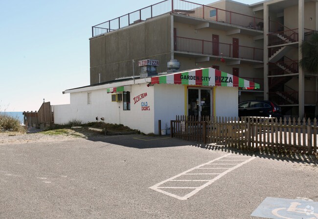
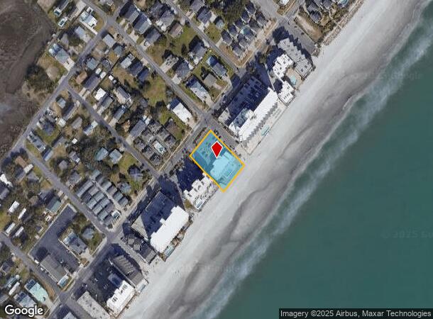
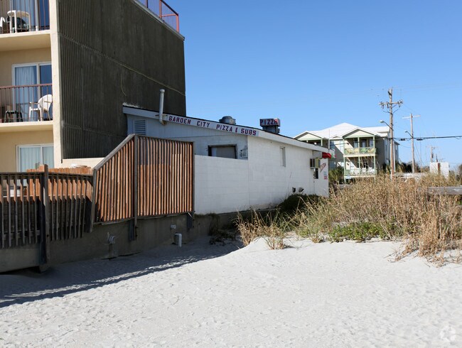
Property Record
1120 N Waccamaw Dr, Murrells Inlet, SC 29576
NEARBY LISTINGS FOR SALE OR LEASE
Property Detail
1120 N Waccamaw Dr
Myrtle Beach-Conway-North Myrtle Beach, SC-NC
Myrtle Dunes
47004010098
MYRTLE DUNES; BL 3 LT 2
Storebuilding
Horry
AE
South Carolina
45051C0803K
2
2025
0.77 AC
2024
Outlying Horry County
051301
Myrtle Beach/Conway
14,496 SF
DEMOGRAPHICS near 1120 N Waccamaw Dr
1 Mile
3 Mile
5 Mile
2024 Total Population
5,489
32,269
64,345
2029 Population
6,990
39,734
77,616
Pop Growth 2024-2029
+ 27.35%
+ 23.13%
+ 20.62%
Average Age
55
53
51
2024 Total Households
2,776
15,559
29,854
HH Growth 2024-2029
+ 26.15%
+ 21.90%
+ 19.53%
Median Household Inc
$58,669
$57,480
$61,658
Avg Household Size
2.00
2.00
2.10
2024 Avg HH Vehicles
2.00
2.00
2.00
Median Home Value
$248,722
$243,596
$252,931
Median Year Built
1988
1991
1996
Nearby Places
Map Layers
Map Styles
 Street
 Aerial
- Restaurants
- Banks
- Shops
- Fitness
- Groceries
PUBLIC TRANSPORTATION
AIRPORT
Myrtle Beach International
DRIVE
WALK
Distance
Myrtle Beach International
21 min
10.1 mi
Freight Ports
Wando Welch Terminal
DRIVE
WALK
Distance
Wando Welch Terminal
108 min
80.2 mi
Nearby Properties
Address
Land Use
TOTAL SIZE
Lot Size
Zoning
Address
Land Use
TOTAL SIZE
Lot Size
Zoning
9,772 SF
130.49 AC
Address
Land Use
TOTAL SIZE
Lot Size
Zoning
3,696 SF
55.20 AC
Address
Land Use
TOTAL SIZE
Lot Size
Zoning
17,408 SF
1.97 AC
Address
Land Use
TOTAL SIZE
Lot Size
Zoning
7,144 SF
187.64 AC
Address
Land Use
TOTAL SIZE
Lot Size
Zoning
151,727 SF
21.25 AC
Address
Land Use
TOTAL SIZE
Lot Size
Zoning
2,510 SF
43.14 AC
Address
Land Use
TOTAL SIZE
Lot Size
Zoning
6,170 SF
2.50 AC
Address
Land Use
TOTAL SIZE
Lot Size
Zoning
25,722 SF
13.73 AC
Address
Land Use
TOTAL SIZE
Lot Size
Zoning
4,800 SF
75.54 AC
Address
Land Use
TOTAL SIZE
Lot Size
Zoning
57,216 SF
2.36 AC
Address
Land Use
TOTAL SIZE
Lot Size
Zoning
65,578 SF
12.12 AC
Address
Land Use
TOTAL SIZE
Lot Size
Zoning
33,862 SF
9.98 AC
Address
Land Use
TOTAL SIZE
Lot Size
Zoning
74,389 SF
1.90 AC
Address
Land Use
TOTAL SIZE
Lot Size
Zoning
49.53 AC
Address
Land Use
TOTAL SIZE
Lot Size
Zoning
6,728 SF
35.71 AC
Address
Land Use
TOTAL SIZE
Lot Size
Zoning
108,250 SF
14.53 AC
Address
Land Use
TOTAL SIZE
Lot Size
Zoning
8,640 SF
5.47 AC
Address
Land Use
TOTAL SIZE
Lot Size
Zoning
80,797 SF
33.77 AC
Address
Land Use
TOTAL SIZE
Lot Size
Zoning
69,048 SF
12.59 AC
Address
Land Use
TOTAL SIZE
Lot Size
Zoning
12.71 AC
Address
Land Use
TOTAL SIZE
Lot Size
Zoning
101,152 SF
2.35 AC
Address
Land Use
TOTAL SIZE
Lot Size
Zoning
22,536 SF
3 AC
Address
Land Use
TOTAL SIZE
Lot Size
Zoning
56,259 SF
8.06 AC
Address
Land Use
TOTAL SIZE
Lot Size
Zoning
73,260 SF
2.73 AC
Address
Land Use
TOTAL SIZE
Lot Size
Zoning
6,133 SF
0.91 AC
Address
Land Use
TOTAL SIZE
Lot Size
Zoning
8,340 SF
5.26 AC
Address
Land Use
TOTAL SIZE
Lot Size
Zoning
148 SF
77.18 AC
Address
Land Use
TOTAL SIZE
Lot Size
Zoning
33,000 SF
7.36 AC
Address
Land Use
TOTAL SIZE
Lot Size
Zoning
4,861 SF
1.05 AC
The World's #1 Commercial Real Estate Marketplace
Connect with us
© 2025 CoStar Group
The information above has been obtained from sources believed reliable. While we do not doubt its accuracy we have not verified it and make no guarantee, warranty or representation about it. It is your responsibility to independently confirm its accuracy and completeness. Any projections, opinions, assumptions, or estimates used are for example only and do not represent the current or future performance of the property. The value of this transaction to you depends on tax and other factors which should be evaluated by your tax, financial, and legal advisors. You and your advisors should conduct a careful, independent investigation of the property to determine to your satisfaction the suitability of the property for your needs.