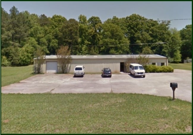
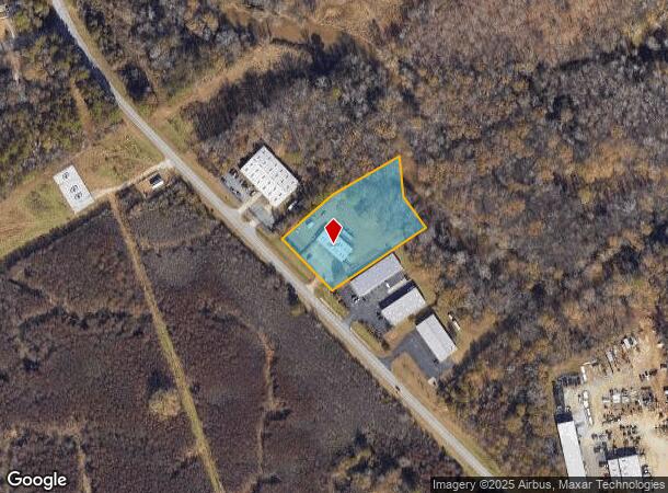
Property Record
1120 Newton Bridge Rd, Athens, GA 30607

NEARBY LISTINGS FOR SALE OR LEASE
Property Detail
1120 Newton Bridge Rd
Athens-Clarke County, GA
Com-St-034->00-03
104-002-E
LOT 4 - 2.35 AC
Industrialgeneral
Clarke
AE
Georgia
13059C0006E
4
2025
2.35 AC
2025
North Athens
130300
Other Market Areas
5,000 SF
DEMOGRAPHICS near 1120 Newton Bridge Rd
1 Mile
3 Mile
5 Mile
2024 Total Population
1,679
17,104
76,397
2029 Population
1,680
17,318
77,516
Pop Growth 2024-2029
+ 0.06%
+ 1.25%
+ 1.46%
Average Age
36
37
34
2024 Total Households
577
6,386
28,636
HH Growth 2024-2029
+ 0.17%
+ 1.32%
+ 1.39%
Median Household Inc
$59,999
$53,231
$46,139
Avg Household Size
2.80
2.50
2.30
2024 Avg HH Vehicles
2.00
2.00
2.00
Median Home Value
$191,269
$215,733
$239,638
Median Year Built
1984
1985
1983
Nearby Places
Map Layers
Map Styles
 Street
 Aerial
- Restaurants
- Banks
- Shops
- Fitness
- Groceries
SALE & LEASE HISTORY
LISTING DATE
SALE/LEASE

Sep 23, 2016
For Sale
Aug 29, 2017
For Lease
Nearby Properties
Address
Land Use
TOTAL SIZE
Lot Size
Zoning
Address
Land Use
TOTAL SIZE
Lot Size
Zoning
85,608 SF
63.75 AC
RM-2
Address
Land Use
TOTAL SIZE
Lot Size
Zoning
112,071 SF
5.27 AC
E-O
Address
Land Use
TOTAL SIZE
Lot Size
Zoning
77,919 SF
8 AC
E-I
Address
Land Use
TOTAL SIZE
Lot Size
Zoning
9,956 SF
7.20 AC
E-O(PD)
Address
Land Use
TOTAL SIZE
Lot Size
Zoning
58,706 SF
12.86 AC
C-G
Address
Land Use
TOTAL SIZE
Lot Size
Zoning
20.74 AC
G
Address
Land Use
TOTAL SIZE
Lot Size
Zoning
19.21 AC
G
Address
Land Use
TOTAL SIZE
Lot Size
Zoning
664,513 SF
84.46 AC
I
Address
Land Use
TOTAL SIZE
Lot Size
Zoning
106,760 SF
10.38 AC
E-O
Address
Land Use
TOTAL SIZE
Lot Size
Zoning
121,382 SF
16.01 AC
C-G
Address
Land Use
TOTAL SIZE
Lot Size
Zoning
15.34 AC
G
Address
Land Use
TOTAL SIZE
Lot Size
Zoning
31,067 SF
5.05 AC
C-O
Address
Land Use
TOTAL SIZE
Lot Size
Zoning
1,378 SF
21.13 AC
RM-1
Address
Land Use
TOTAL SIZE
Lot Size
Zoning
62,856 SF
37 AC
I
Address
Land Use
TOTAL SIZE
Lot Size
Zoning
42,548 SF
5.34 AC
C-O
Address
Land Use
TOTAL SIZE
Lot Size
Zoning
50,400 SF
3.29 AC
C-G
Address
Land Use
TOTAL SIZE
Lot Size
Zoning
10,651 SF
0.26 AC
C-N
Address
Land Use
TOTAL SIZE
Lot Size
Zoning
2,113 SF
8.54 AC
C-G
Address
Land Use
TOTAL SIZE
Lot Size
Zoning
129,424 SF
109.82 AC
I
Address
Land Use
TOTAL SIZE
Lot Size
Zoning
262,400 SF
222.46 AC
GI
Address
Land Use
TOTAL SIZE
Lot Size
Zoning
23.30 AC
P
Address
Land Use
TOTAL SIZE
Lot Size
Zoning
65,971 SF
8.16 AC
E-I
Address
Land Use
TOTAL SIZE
Lot Size
Zoning
161,439 SF
10.56 AC
I
Address
Land Use
TOTAL SIZE
Lot Size
Zoning
78,400 SF
5.29 AC
E-I
Address
Land Use
TOTAL SIZE
Lot Size
Zoning
63,207 SF
5.60 AC
C-N
Address
Land Use
TOTAL SIZE
Lot Size
Zoning
7,500 SF
280.85 AC
001
Address
Land Use
TOTAL SIZE
Lot Size
Zoning
15,145 SF
3.28 AC
C-N
Address
Land Use
TOTAL SIZE
Lot Size
Zoning
24,210 SF
0.39 AC
E-I
Address
Land Use
TOTAL SIZE
Lot Size
Zoning
1,580 SF
2.46 AC
RM-1
Address
Land Use
TOTAL SIZE
Lot Size
Zoning
24,500 SF
34.72 AC
AR
The World's #1 Commercial Real Estate Marketplace
Connect with us
© 2025 CoStar Group
The information above has been obtained from sources believed reliable. While we do not doubt its accuracy we have not verified it and make no guarantee, warranty or representation about it. It is your responsibility to independently confirm its accuracy and completeness. Any projections, opinions, assumptions, or estimates used are for example only and do not represent the current or future performance of the property. The value of this transaction to you depends on tax and other factors which should be evaluated by your tax, financial, and legal advisors. You and your advisors should conduct a careful, independent investigation of the property to determine to your satisfaction the suitability of the property for your needs.