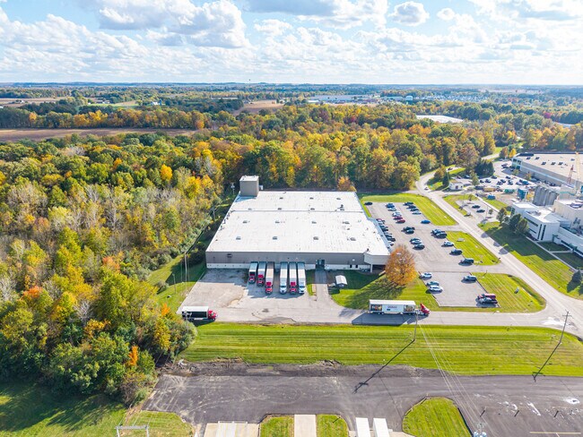
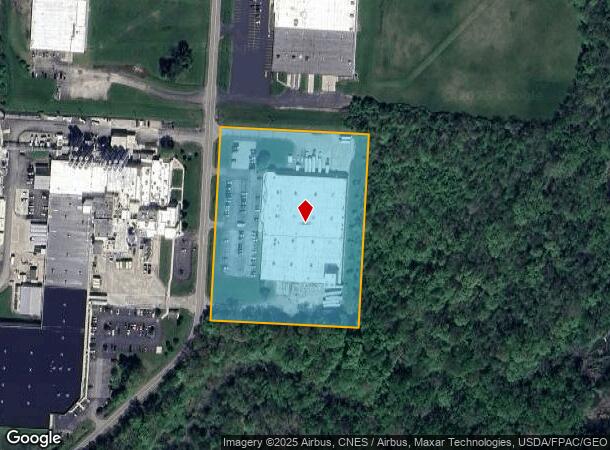
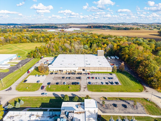
Property Record
1120 O Neill Dr, Hebron, OH 43025
Current Lease Availabilities
NEARBY LISTINGS FOR SALE OR LEASE
Property Detail
1120 O Neill Dr
073-331320-11.000
South Part
Warehouse
5.938 AC R12 T1 Q3
X
Licking
39045C0100G
Ohio
2024
5.93 AC
2024
Licking County
759101
Columbus
75,600 SF
Columbus, OH
DEMOGRAPHICS near 1120 O Neill Dr
1 Mile
3 Mile
5 Mile
2024 Total Population
674
7,625
26,708
2029 Population
704
8,021
28,196
Pop Growth 2024-2029
+ 4.45%
+ 5.19%
+ 5.57%
Average Age
44
43
43
2024 Total Households
295
3,301
11,419
HH Growth 2024-2029
+ 4.41%
+ 5.21%
+ 5.61%
Median Household Inc
$42,894
$63,613
$68,647
Avg Household Size
2.30
2.30
2.30
2024 Avg HH Vehicles
2.00
2.00
2.00
Median Home Value
$157,777
$173,629
$196,235
Median Year Built
1969
1977
1977
Nearby Places
Map Layers
Map Styles
 Street
 Aerial
- Restaurants
- Banks
- Shops
- Fitness
- Groceries
PUBLIC TRANSPORTATION
AIRPORT
John Glenn Columbus International
DRIVE
WALK
Distance
John Glenn Columbus International
42 min
30.9 mi
Rickenbacker International
DRIVE
WALK
Distance
Rickenbacker International
45 min
33.2 mi
Nearby Properties
Address
Land Use
TOTAL SIZE
Lot Size
Zoning
Address
Land Use
TOTAL SIZE
Lot Size
Zoning
332,516 SF
44.81 AC
Address
Land Use
TOTAL SIZE
Lot Size
Zoning
401,863 SF
22.18 AC
Address
Land Use
TOTAL SIZE
Lot Size
Zoning
50,871 SF
51.13 AC
Address
Land Use
TOTAL SIZE
Lot Size
Zoning
125,645 SF
36.96 AC
Address
Land Use
TOTAL SIZE
Lot Size
Zoning
187,286 SF
113.76 AC
Address
Land Use
TOTAL SIZE
Lot Size
Zoning
68,954 SF
64.81 AC
Address
Land Use
TOTAL SIZE
Lot Size
Zoning
172,603 SF
15.88 AC
Address
Land Use
TOTAL SIZE
Lot Size
Zoning
59,992 SF
118.45 AC
Address
Land Use
TOTAL SIZE
Lot Size
Zoning
398,678 SF
12.04 AC
Address
Land Use
TOTAL SIZE
Lot Size
Zoning
150,000 SF
11.18 AC
Address
Land Use
TOTAL SIZE
Lot Size
Zoning
58,368 SF
25 AC
Address
Land Use
TOTAL SIZE
Lot Size
Zoning
2,067,827 SF
45.19 AC
Address
Land Use
TOTAL SIZE
Lot Size
Zoning
399,520 SF
21.62 AC
Address
Land Use
TOTAL SIZE
Lot Size
Zoning
18,198 SF
12.83 AC
Address
Land Use
TOTAL SIZE
Lot Size
Zoning
248,400 SF
12.08 AC
Address
Land Use
TOTAL SIZE
Lot Size
Zoning
112,430 SF
15.33 AC
Address
Land Use
TOTAL SIZE
Lot Size
Zoning
523,249 SF
40 AC
Address
Land Use
TOTAL SIZE
Lot Size
Zoning
192,701 SF
10.28 AC
Address
Land Use
TOTAL SIZE
Lot Size
Zoning
1,165 SF
141.30 AC
Address
Land Use
TOTAL SIZE
Lot Size
Zoning
73,372 SF
21.86 AC
Address
Land Use
TOTAL SIZE
Lot Size
Zoning
Address
Land Use
TOTAL SIZE
Lot Size
Zoning
61,570 SF
5.35 AC
Address
Land Use
TOTAL SIZE
Lot Size
Zoning
249,920 SF
13.62 AC
Address
Land Use
TOTAL SIZE
Lot Size
Zoning
57,544 SF
2.67 AC
Address
Land Use
TOTAL SIZE
Lot Size
Zoning
91,676 SF
16.49 AC
Address
Land Use
TOTAL SIZE
Lot Size
Zoning
2,254 SF
8.48 AC
Address
Land Use
TOTAL SIZE
Lot Size
Zoning
66,606 SF
9.04 AC
Address
Land Use
TOTAL SIZE
Lot Size
Zoning
60,000 SF
12 AC
Address
Land Use
TOTAL SIZE
Lot Size
Zoning
68,656 SF
7.48 AC
Address
Land Use
TOTAL SIZE
Lot Size
Zoning
32,340 SF
4.55 AC
The World's #1 Commercial Real Estate Marketplace
Connect with us
© 2026 CoStar Group
The information above has been obtained from sources believed reliable. While we do not doubt its accuracy we have not verified it and make no guarantee, warranty or representation about it. It is your responsibility to independently confirm its accuracy and completeness. Any projections, opinions, assumptions, or estimates used are for example only and do not represent the current or future performance of the property. The value of this transaction to you depends on tax and other factors which should be evaluated by your tax, financial, and legal advisors. You and your advisors should conduct a careful, independent investigation of the property to determine to your satisfaction the suitability of the property for your needs.