Property Record
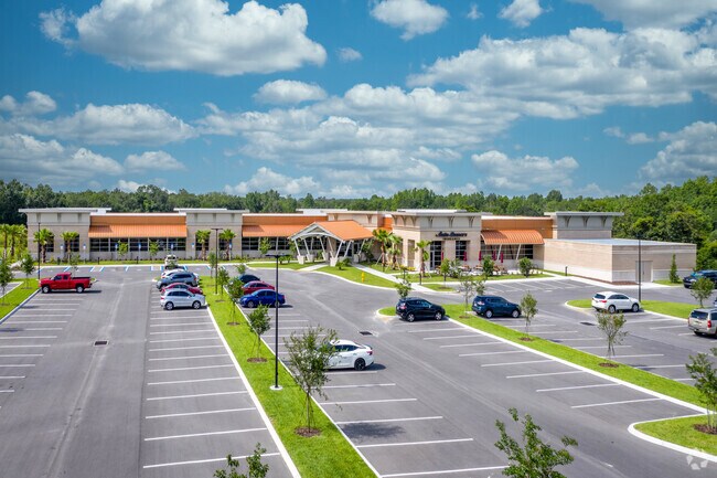
1120 S Parkway Frontage Rd, Lakeland, FL 33813


NEARBY LISTINGS FOR SALE OR LEASE
Property Detail
1120 S Parkway Frontage Rd
23-29-01-000000-033080
Alamo Co
Financialbuilding
COMM NW COR OF SEC RUN S89-57-36E 100.95 FT S00-38-39E 270 FT S89-57-36E 1067.93 FT S00-38-39E 27.92 FT CONT S00-38-39E 300.55 FT S89-51-55W 110 FT S00-38-39E 520 FT S89-33-05W 146 FT N00-38- 39W 100 FT S89-33-05W 252.83 FT N00-38-39W 358.07 FT S89-2
A
Polk
12105C0480G
Florida
2024
5.62 AC
2025
Polk County
011901
Tampa/St Petersburg
41,601 SF
Lakeland-Winter Haven, FL
DEMOGRAPHICS near 1120 S Parkway Frontage Rd
1 Mile
3 Mile
5 Mile
2024 Total Population
5,388
58,462
150,513
2029 Population
6,391
69,582
179,051
Pop Growth 2024-2029
+ 18.62%
+ 19.02%
+ 18.96%
Average Age
45
42
40
2024 Total Households
2,550
24,259
58,230
HH Growth 2024-2029
+ 18.47%
+ 18.99%
+ 19.22%
Median Household Inc
$55,700
$63,917
$61,273
Avg Household Size
2.00
2.30
2.40
2024 Avg HH Vehicles
2.00
2.00
2.00
Median Home Value
$195,736
$219,351
$228,759
Median Year Built
1983
1979
1981
Nearby Places
Map Layers
Map Styles
 Street
 Aerial
- Restaurants
- Banks
- Shops
- Fitness
- Groceries
PUBLIC TRANSPORTATION
COMMUTER RAIL
Lakeland (Silver Star - Amtrak)
DRIVE
WALK
Distance
Lakeland (Silver Star - Amtrak)
11 min
5.6 mi
Freight Ports
Port of Tampa Bay
DRIVE
WALK
Distance
Port of Tampa Bay
47 min
35.5 mi
Nearby Properties
Address
Land Use
TOTAL SIZE
Lot Size
Zoning
Address
Land Use
TOTAL SIZE
Lot Size
Zoning
518,028 SF
195.69 AC
Address
Land Use
TOTAL SIZE
Lot Size
Zoning
315,901 SF
20.55 AC
Address
Land Use
TOTAL SIZE
Lot Size
Zoning
24,871 SF
54.24 AC
RB1
Address
Land Use
TOTAL SIZE
Lot Size
Zoning
364,518 SF
23.38 AC
Address
Land Use
TOTAL SIZE
Lot Size
Zoning
492,859 SF
135.58 AC
Address
Land Use
TOTAL SIZE
Lot Size
Zoning
296,264 SF
26.74 AC
Address
Land Use
TOTAL SIZE
Lot Size
Zoning
363,147 SF
76.15 AC
Address
Land Use
TOTAL SIZE
Lot Size
Zoning
277,272 SF
19.35 AC
RA4
Address
Land Use
TOTAL SIZE
Lot Size
Zoning
432,087 SF
626.03 AC
PUD
Address
Land Use
TOTAL SIZE
Lot Size
Zoning
333,560 SF
44.88 AC
IND
Address
Land Use
TOTAL SIZE
Lot Size
Zoning
202,378 SF
14.39 AC
PUD
Address
Land Use
TOTAL SIZE
Lot Size
Zoning
342,987 SF
16.81 AC
Address
Land Use
TOTAL SIZE
Lot Size
Zoning
103,446 SF
2.12 AC
RB1
Address
Land Use
TOTAL SIZE
Lot Size
Zoning
218,162 SF
16.32 AC
MF12
Address
Land Use
TOTAL SIZE
Lot Size
Zoning
77,358 SF
8.34 AC
PUD
Address
Land Use
TOTAL SIZE
Lot Size
Zoning
76,250 SF
5.25 AC
Address
Land Use
TOTAL SIZE
Lot Size
Zoning
242,284 SF
22.90 AC
C4
Address
Land Use
TOTAL SIZE
Lot Size
Zoning
148,182 SF
24.15 AC
Address
Land Use
TOTAL SIZE
Lot Size
Zoning
119,141 SF
15.04 AC
RA4
Address
Land Use
TOTAL SIZE
Lot Size
Zoning
63,740 SF
8.63 AC
Address
Land Use
TOTAL SIZE
Lot Size
Zoning
162,990 SF
11.47 AC
MF16
Address
Land Use
TOTAL SIZE
Lot Size
Zoning
278,400 SF
22.83 AC
XX
Address
Land Use
TOTAL SIZE
Lot Size
Zoning
128,382 SF
6.42 AC
MF22
Address
Land Use
TOTAL SIZE
Lot Size
Zoning
106,000 SF
15.35 AC
RA3
Address
Land Use
TOTAL SIZE
Lot Size
Zoning
101,103 SF
13.87 AC
Address
Land Use
TOTAL SIZE
Lot Size
Zoning
160,914 SF
8.72 AC
MF22
Address
Land Use
TOTAL SIZE
Lot Size
Zoning
216,358 SF
135.58 AC
Address
Land Use
TOTAL SIZE
Lot Size
Zoning
147,718 SF
52.29 AC
PUD
Address
Land Use
TOTAL SIZE
Lot Size
Zoning
77,232 SF
0.46 AC
Address
Land Use
TOTAL SIZE
Lot Size
Zoning
80,208 SF
4.33 AC
The World's #1 Commercial Real Estate Marketplace
Connect with us
© 2026 CoStar Group
The information above has been obtained from sources believed reliable. While we do not doubt its accuracy we have not verified it and make no guarantee, warranty or representation about it. It is your responsibility to independently confirm its accuracy and completeness. Any projections, opinions, assumptions, or estimates used are for example only and do not represent the current or future performance of the property. The value of this transaction to you depends on tax and other factors which should be evaluated by your tax, financial, and legal advisors. You and your advisors should conduct a careful, independent investigation of the property to determine to your satisfaction the suitability of the property for your needs.