Property Record
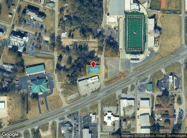
1120 Stewart St, Oxford, AL 36203
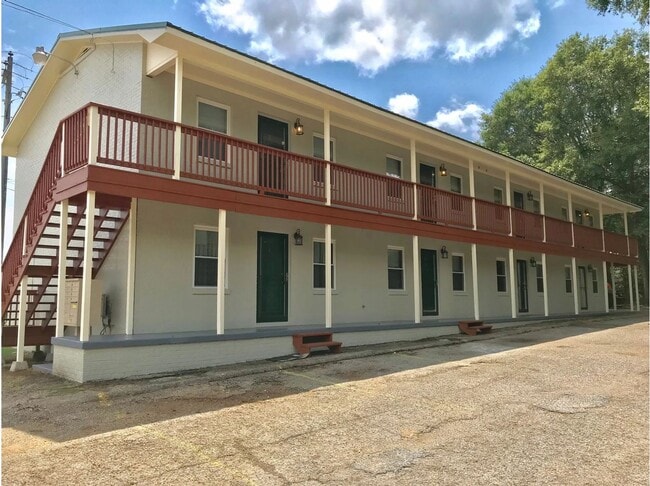
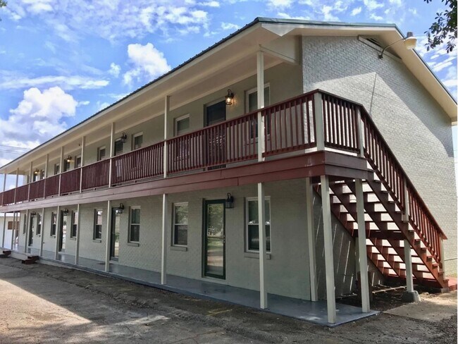
This Property Is For Sale
NEARBY LISTINGS FOR SALE OR LEASE
-
-
View all Oxford listings for sale on LoopNet.com
Property Detail
1120 Stewart St
21-09-30-1-004-057.000
Oxford
Apartment
SEC 30 TSP 16S RNG 08E CITY OF OXFORD P/O BLK 43 DESC AS BE G 247 S OF SW INT 6TH ST & STEWART ST TH S 97 NW 141.9 N 94 E 147
X
Calhoun
01015C0402E
Alabama
2025
0.32 AC
2025
Gadsden/Anniston Area
001201
Other Market Areas
4,482 SF
Anniston-Oxford-Jacksonville, AL
DEMOGRAPHICS near 1120 Stewart St
1 Mile
3 Mile
5 Mile
2024 Total Population
2,778
19,420
43,335
2029 Population
2,747
19,080
42,844
Pop Growth 2024-2029
(1.12%)
(1.75%)
(1.13%)
Average Age
41
41
42
2024 Total Households
1,081
7,707
17,742
HH Growth 2024-2029
(1.30%)
(1.91%)
(1.18%)
Median Household Inc
$33,883
$52,245
$48,336
Avg Household Size
2.30
2.30
2.30
2024 Avg HH Vehicles
2.00
2.00
2.00
Median Home Value
$92,399
$156,316
$142,407
Median Year Built
1966
1978
1975
Nearby Places
- Restaurants
- Banks
- Shops
- Fitness
- Groceries
PUBLIC TRANSPORTATION
COMMUTER RAIL
Anniston Amtrak Station (Crescent - Amtrak)
DRIVE
WALK
Distance
Anniston Amtrak Station (Crescent - Amtrak)
7 min
3.7 mi
Freight Ports
Port of Panama City
DRIVE
WALK
Distance
Port of Panama City
358 min
289.6 mi
Nearby Properties
Address
Land Use
TOTAL SIZE
Lot Size
Zoning
Address
Land Use
TOTAL SIZE
Lot Size
Zoning
128,399 SF
17 AC
Address
Land Use
TOTAL SIZE
Lot Size
Zoning
23,480 SF
14 AC
Address
Land Use
TOTAL SIZE
Lot Size
Zoning
5.32 AC
Address
Land Use
TOTAL SIZE
Lot Size
Zoning
126,689 SF
8.49 AC
Address
Land Use
TOTAL SIZE
Lot Size
Zoning
7,752 SF
182 AC
Address
Land Use
TOTAL SIZE
Lot Size
Zoning
18.90 AC
Address
Land Use
TOTAL SIZE
Lot Size
Zoning
1,972 SF
22.80 AC
Address
Land Use
TOTAL SIZE
Lot Size
Zoning
17,254 SF
22 AC
Address
Land Use
TOTAL SIZE
Lot Size
Zoning
87,750 SF
25 AC
Address
Land Use
TOTAL SIZE
Lot Size
Zoning
4,356 SF
60.40 AC
Address
Land Use
TOTAL SIZE
Lot Size
Zoning
1,335 SF
76 AC
Address
Land Use
TOTAL SIZE
Lot Size
Zoning
341,374 SF
15.88 AC
Address
Land Use
TOTAL SIZE
Lot Size
Zoning
201,670 SF
27.50 AC
Address
Land Use
TOTAL SIZE
Lot Size
Zoning
74,927 SF
2.47 AC
Address
Land Use
TOTAL SIZE
Lot Size
Zoning
346,532 SF
41 AC
Address
Land Use
TOTAL SIZE
Lot Size
Zoning
64,772 SF
2.56 AC
Address
Land Use
TOTAL SIZE
Lot Size
Zoning
56,520 SF
2.51 AC
Address
Land Use
TOTAL SIZE
Lot Size
Zoning
4,366 SF
0.97 AC
Address
Land Use
TOTAL SIZE
Lot Size
Zoning
102,436 SF
12.52 AC
Address
Land Use
TOTAL SIZE
Lot Size
Zoning
54,232 SF
2.27 AC
Address
Land Use
TOTAL SIZE
Lot Size
Zoning
50,180 SF
7.60 AC
Address
Land Use
TOTAL SIZE
Lot Size
Zoning
135,128 SF
10.01 AC
Address
Land Use
TOTAL SIZE
Lot Size
Zoning
14,015 SF
8.50 AC
Address
Land Use
TOTAL SIZE
Lot Size
Zoning
12,695 SF
0.75 AC
Address
Land Use
TOTAL SIZE
Lot Size
Zoning
86,508 SF
20 AC
Address
Land Use
TOTAL SIZE
Lot Size
Zoning
Address
Land Use
TOTAL SIZE
Lot Size
Zoning
31,104 SF
36 AC
Address
Land Use
TOTAL SIZE
Lot Size
Zoning
227,530 SF
24 AC
Address
Land Use
TOTAL SIZE
Lot Size
Zoning
4,118 SF
15.74 AC
Address
Land Use
TOTAL SIZE
Lot Size
Zoning
6,400 SF
12.24 AC
The World's #1 Commercial Real Estate Marketplace
Connect with us
© 2025 CoStar Group
The information above has been obtained from sources believed reliable. While we do not doubt its accuracy we have not verified it and make no guarantee, warranty or representation about it. It is your responsibility to independently confirm its accuracy and completeness. Any projections, opinions, assumptions, or estimates used are for example only and do not represent the current or future performance of the property. The value of this transaction to you depends on tax and other factors which should be evaluated by your tax, financial, and legal advisors. You and your advisors should conduct a careful, independent investigation of the property to determine to your satisfaction the suitability of the property for your needs.