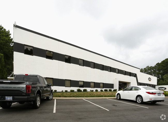
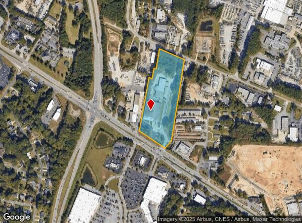
Property Record
1120 Us 70 Hwy W, Garner, NC 27529

NEARBY LISTINGS FOR SALE OR LEASE
Property Detail
1120 Us 70 Hwy W
1701.12-86-1984-000
Traytee Subdivision
Warehouse
A E ALLEN LAND
X
Wake
3720170100K
North Carolina
0
10.80 AC
2025
Southeast Wake County
054502
Raleigh/Durham
79,349 SF
Raleigh, NC
DEMOGRAPHICS near 1120 Us 70 Hwy W
1 Mile
3 Mile
5 Mile
2024 Total Population
4,161
50,279
150,841
2029 Population
4,483
54,708
164,431
Pop Growth 2024-2029
+ 7.74%
+ 8.81%
+ 9.01%
Average Age
39
39
37
2024 Total Households
1,688
19,315
59,070
HH Growth 2024-2029
+ 7.76%
+ 8.78%
+ 9.40%
Median Household Inc
$62,275
$57,517
$61,156
Avg Household Size
2.30
2.50
2.30
2024 Avg HH Vehicles
2.00
2.00
2.00
Median Home Value
$204,393
$227,983
$274,743
Median Year Built
1975
1986
1993
Nearby Places
Map Layers
Map Styles
 Street
 Aerial
- Restaurants
- Banks
- Shops
- Fitness
- Groceries
PUBLIC TRANSPORTATION
COMMUTER RAIL
Raleigh Union Station (Piedmont - North Carolina by Train (NC Train))
DRIVE
WALK
Distance
Raleigh Union Station (Piedmont - North Carolina by Train (NC Train))
9 min
4.7 mi
AIRPORT
Raleigh-Durham International
DRIVE
WALK
Distance
Raleigh-Durham International
27 min
17.7 mi
Freight Ports
Port of Wilmington
DRIVE
WALK
Distance
Port of Wilmington
148 min
128.5 mi
Nearby Properties
Address
Land Use
TOTAL SIZE
Lot Size
Zoning
Address
Land Use
TOTAL SIZE
Lot Size
Zoning
2,583,746 SF
87.16 AC
HI
Address
Land Use
TOTAL SIZE
Lot Size
Zoning
573,338 SF
19.34 AC
IH
Address
Land Use
TOTAL SIZE
Lot Size
Zoning
127,409 SF
734.31 AC
R-1
Address
Land Use
TOTAL SIZE
Lot Size
Zoning
327,776 SF
14.48 AC
CX-5
Address
Land Use
TOTAL SIZE
Lot Size
Zoning
235,588 SF
128.17 AC
OX-3
Address
Land Use
TOTAL SIZE
Lot Size
Zoning
370,651 SF
24.83 AC
IX-3
Address
Land Use
TOTAL SIZE
Lot Size
Zoning
276,494 SF
58.90 AC
R-6
Address
Land Use
TOTAL SIZE
Lot Size
Zoning
280,473 SF
28.12 AC
R-10
Address
Land Use
TOTAL SIZE
Lot Size
Zoning
275,019 SF
17.04 AC
MF-A
Address
Land Use
TOTAL SIZE
Lot Size
Zoning
292,610 SF
7.33 AC
PD
Address
Land Use
TOTAL SIZE
Lot Size
Zoning
220,352 SF
16.82 AC
MF-A
Address
Land Use
TOTAL SIZE
Lot Size
Zoning
340,994 SF
27.24 AC
MF-B
Address
Land Use
TOTAL SIZE
Lot Size
Zoning
260,355 SF
18.48 AC
MF-A
Address
Land Use
TOTAL SIZE
Lot Size
Zoning
487,635 SF
27.81 AC
IX-3
Address
Land Use
TOTAL SIZE
Lot Size
Zoning
275,215 SF
18.17 AC
HI
Address
Land Use
TOTAL SIZE
Lot Size
Zoning
227,910 SF
20.77 AC
MF-A
Address
Land Use
TOTAL SIZE
Lot Size
Zoning
259,480 SF
17.19 AC
HI
Address
Land Use
TOTAL SIZE
Lot Size
Zoning
74,356 SF
6.02 AC
IH
Address
Land Use
TOTAL SIZE
Lot Size
Zoning
77.64 AC
CX-20
Address
Land Use
TOTAL SIZE
Lot Size
Zoning
156,078 SF
67.93 AC
HI
Address
Land Use
TOTAL SIZE
Lot Size
Zoning
166,859 SF
17.79 AC
R4
Address
Land Use
TOTAL SIZE
Lot Size
Zoning
101,311 SF
16.88 AC
NMX
Address
Land Use
TOTAL SIZE
Lot Size
Zoning
69,215 SF
20.98 AC
IX-3
Address
Land Use
TOTAL SIZE
Lot Size
Zoning
98.77 AC
OX-3
Address
Land Use
TOTAL SIZE
Lot Size
Zoning
194,674 SF
11.65 AC
RX-3
Address
Land Use
TOTAL SIZE
Lot Size
Zoning
185,150 SF
27.46 AC
R-6
Address
Land Use
TOTAL SIZE
Lot Size
Zoning
99,963 SF
26.84 AC
R2
Address
Land Use
TOTAL SIZE
Lot Size
Zoning
126,735 SF
9.89 AC
MF-A
Address
Land Use
TOTAL SIZE
Lot Size
Zoning
101,215 SF
7.49 AC
IX-3
Address
Land Use
TOTAL SIZE
Lot Size
Zoning
115,908 SF
CX-5
The World's #1 Commercial Real Estate Marketplace
Connect with us
© 2025 CoStar Group
The information above has been obtained from sources believed reliable. While we do not doubt its accuracy we have not verified it and make no guarantee, warranty or representation about it. It is your responsibility to independently confirm its accuracy and completeness. Any projections, opinions, assumptions, or estimates used are for example only and do not represent the current or future performance of the property. The value of this transaction to you depends on tax and other factors which should be evaluated by your tax, financial, and legal advisors. You and your advisors should conduct a careful, independent investigation of the property to determine to your satisfaction the suitability of the property for your needs.