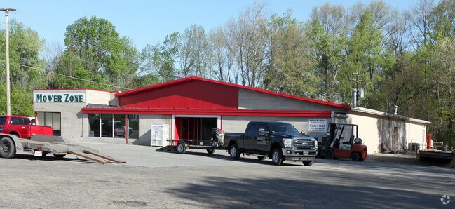
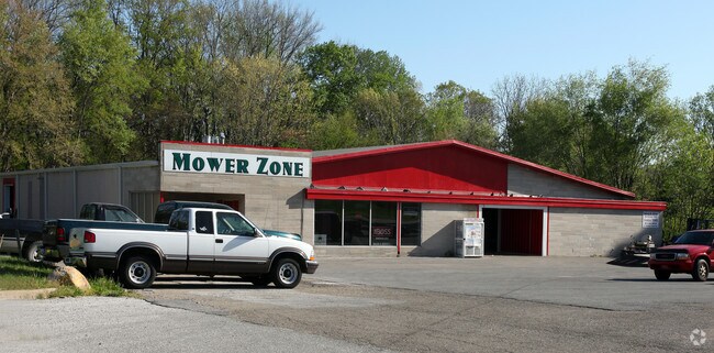
Property Record
1120 W Main St, Danville, IN 46122
NEARBY LISTINGS FOR SALE OR LEASE
-
-
View all Danville listings for sale on LoopNet.com
Property Detail
1120 W Main St
32-11-04-380-017.000-003
PT SE SE 4-15-1W 2.88AC
Commercialnec
Hendricks
X
Indiana
18063C0143D
2.88 AC
2024
Hendricks County
2024
Indianapolis
210501
Indianapolis-Carmel-Anderson, IN
11,104 SF
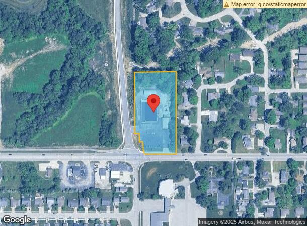
DEMOGRAPHICS near 1120 W Main St
1 Mile
3 Mile
5 Mile
2024 Total Population
5,875
12,021
18,760
2029 Population
6,587
13,458
21,015
Pop Growth 2024-2029
+ 12.12%
+ 11.95%
+ 12.02%
Average Age
38
40
40
2024 Total Households
2,154
4,494
7,104
HH Growth 2024-2029
+ 12.12%
+ 11.99%
+ 12.04%
Median Household Inc
$90,753
$93,328
$95,885
Avg Household Size
2.60
2.60
2.60
2024 Avg HH Vehicles
2.00
2.00
2.00
Median Home Value
$195,698
$221,172
$241,657
Median Year Built
1975
1986
1990
Nearby Places
Map Layers
Map Styles
 Street
 Aerial
- Restaurants
- Banks
- Shops
- Fitness
- Groceries
PUBLIC TRANSPORTATION
AIRPORT
Indianapolis International
DRIVE
WALK
Distance
Indianapolis International
34 min
18.3 mi
Freight Ports
Port of Toledo
DRIVE
WALK
Distance
Port of Toledo
304 min
245.7 mi
Nearby Properties
Address
Land Use
TOTAL SIZE
Lot Size
Zoning
Address
Land Use
TOTAL SIZE
Lot Size
Zoning
156,080 SF
15.18 AC
Address
Land Use
TOTAL SIZE
Lot Size
Zoning
10,500 SF
10 AC
Address
Land Use
TOTAL SIZE
Lot Size
Zoning
64,062 SF
7.53 AC
Address
Land Use
TOTAL SIZE
Lot Size
Zoning
17,100 SF
5.99 AC
Address
Land Use
TOTAL SIZE
Lot Size
Zoning
18,970 SF
3.26 AC
Address
Land Use
TOTAL SIZE
Lot Size
Zoning
43,482 SF
10 AC
Address
Land Use
TOTAL SIZE
Lot Size
Zoning
19,932 SF
12.34 AC
Address
Land Use
TOTAL SIZE
Lot Size
Zoning
5,600 SF
12.29 AC
Address
Land Use
TOTAL SIZE
Lot Size
Zoning
29,586 SF
7.44 AC
Address
Land Use
TOTAL SIZE
Lot Size
Zoning
12,360 SF
6.86 AC
Address
Land Use
TOTAL SIZE
Lot Size
Zoning
17,904 SF
14.34 AC
Address
Land Use
TOTAL SIZE
Lot Size
Zoning
5,075 SF
2.13 AC
Address
Land Use
TOTAL SIZE
Lot Size
Zoning
12,480 SF
2.82 AC
Address
Land Use
TOTAL SIZE
Lot Size
Zoning
16,000 SF
1.42 AC
Address
Land Use
TOTAL SIZE
Lot Size
Zoning
4,476 SF
3.20 AC
Address
Land Use
TOTAL SIZE
Lot Size
Zoning
9,547 SF
16.64 AC
Address
Land Use
TOTAL SIZE
Lot Size
Zoning
37,976 SF
3.03 AC
Address
Land Use
TOTAL SIZE
Lot Size
Zoning
3,000 SF
5.81 AC
Address
Land Use
TOTAL SIZE
Lot Size
Zoning
8,680 SF
73.33 AC
Address
Land Use
TOTAL SIZE
Lot Size
Zoning
12,540 SF
4.90 AC
Address
Land Use
TOTAL SIZE
Lot Size
Zoning
10,113 SF
1.40 AC
Address
Land Use
TOTAL SIZE
Lot Size
Zoning
10,974 SF
0.18 AC
Address
Land Use
TOTAL SIZE
Lot Size
Zoning
12,382 SF
1.54 AC
Address
Land Use
TOTAL SIZE
Lot Size
Zoning
12,205 SF
1.54 AC
Address
Land Use
TOTAL SIZE
Lot Size
Zoning
9,894 SF
1.69 AC
Address
Land Use
TOTAL SIZE
Lot Size
Zoning
7,280 SF
27.71 AC
Address
Land Use
TOTAL SIZE
Lot Size
Zoning
4,652 SF
5.72 AC
Address
Land Use
TOTAL SIZE
Lot Size
Zoning
15,761 SF
1.26 AC
Address
Land Use
TOTAL SIZE
Lot Size
Zoning
16,964 SF
4.74 AC
The World's #1 Commercial Real Estate Marketplace
Connect with us
© 2025 CoStar Group
The information above has been obtained from sources believed reliable. While we do not doubt its accuracy we have not verified it and make no guarantee, warranty or representation about it. It is your responsibility to independently confirm its accuracy and completeness. Any projections, opinions, assumptions, or estimates used are for example only and do not represent the current or future performance of the property. The value of this transaction to you depends on tax and other factors which should be evaluated by your tax, financial, and legal advisors. You and your advisors should conduct a careful, independent investigation of the property to determine to your satisfaction the suitability of the property for your needs.