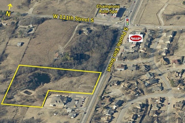
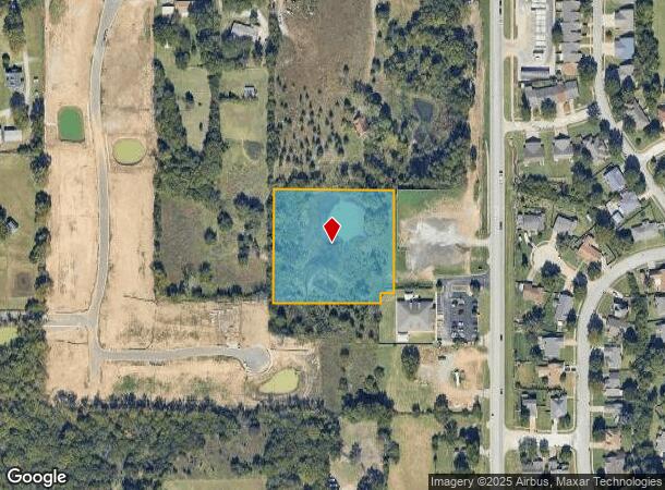
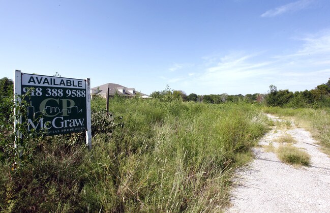
Property Record
11202 S Elm St W, Jenks, OK 74037
NEARBY LISTINGS FOR SALE OR LEASE
Property Detail
11202 S Elm St W
Tulsa, OK
Unplatted
98236-82-36-03510
E/2 N/2 S/2 NE NE LESS BEG SECR THEREOF TH N30.42 W349.75 S30.42 E349.75 TO POB & LESS BEG 662.05S NEC NE TH S300.61 W310 N300.58 E310 TO POB SEC 36 18 12 2.617ACS
Taxexempt
Tulsa
X
Oklahoma
40143C0363L
2.62 AC
0
South
2025
Tulsa
006710
DEMOGRAPHICS near 11202 S Elm St W
1 Mile
3 Mile
5 Mile
2024 Total Population
6,400
41,037
112,796
2029 Population
6,606
42,521
116,750
Pop Growth 2024-2029
+ 3.22%
+ 3.62%
+ 3.51%
Average Age
36
37
38
2024 Total Households
2,077
14,941
43,292
HH Growth 2024-2029
+ 3.27%
+ 3.59%
+ 3.45%
Median Household Inc
$101,039
$84,540
$77,822
Avg Household Size
3.10
2.70
2.50
2024 Avg HH Vehicles
2.00
2.00
2.00
Median Home Value
$246,227
$266,609
$287,598
Median Year Built
1999
1999
1991
Nearby Places
Map Layers
Map Styles
 Street
 Aerial
- Restaurants
- Banks
- Shops
- Fitness
- Groceries
PUBLIC TRANSPORTATION
AIRPORT
Tulsa International
DRIVE
WALK
Distance
Tulsa International
32 min
22.4 mi
Freight Ports
Tulsa Port Of Catoosa
DRIVE
WALK
Distance
Tulsa Port Of Catoosa
35 min
27.4 mi
SALE & LEASE HISTORY
LISTING DATE
SALE/LEASE

Sep 24, 2016
For Sale
Feb 19, 2019
For Sale
Nearby Properties
Address
Land Use
TOTAL SIZE
Lot Size
Zoning
Address
Land Use
TOTAL SIZE
Lot Size
Zoning
1,584,609 SF
84.41 AC
AG
Address
Land Use
TOTAL SIZE
Lot Size
Zoning
49,344 SF
5.34 AC
CG
Address
Land Use
TOTAL SIZE
Lot Size
Zoning
415.28 AC
IL
Address
Land Use
TOTAL SIZE
Lot Size
Zoning
52,441 SF
12.79 AC
CS
Address
Land Use
TOTAL SIZE
Lot Size
Zoning
58,907 SF
5 AC
CG
Address
Land Use
TOTAL SIZE
Lot Size
Zoning
301,267 SF
25.06 AC
IL
Address
Land Use
TOTAL SIZE
Lot Size
Zoning
358,394 SF
38.86 AC
Address
Land Use
TOTAL SIZE
Lot Size
Zoning
58,977 SF
15.85 AC
CS
Address
Land Use
TOTAL SIZE
Lot Size
Zoning
31,313 SF
17.95 AC
IL
Address
Land Use
TOTAL SIZE
Lot Size
Zoning
365,433 SF
18.39 AC
CO
Address
Land Use
TOTAL SIZE
Lot Size
Zoning
81,732 SF
26.20 AC
AG
Address
Land Use
TOTAL SIZE
Lot Size
Zoning
49,025 SF
10.75 AC
AG
Address
Land Use
TOTAL SIZE
Lot Size
Zoning
72,746 SF
3.93 AC
AG
Address
Land Use
TOTAL SIZE
Lot Size
Zoning
87,304 SF
3.29 AC
CN
Address
Land Use
TOTAL SIZE
Lot Size
Zoning
14,496 SF
100.21 AC
AG
Address
Land Use
TOTAL SIZE
Lot Size
Zoning
137,364 SF
14.65 AC
RS3
Address
Land Use
TOTAL SIZE
Lot Size
Zoning
8.03 AC
CS
Address
Land Use
TOTAL SIZE
Lot Size
Zoning
186,012 SF
9.31 AC
RS3
Address
Land Use
TOTAL SIZE
Lot Size
Zoning
331,125 SF
17.64 AC
CG
Address
Land Use
TOTAL SIZE
Lot Size
Zoning
1 SF
25.77 AC
AG
Address
Land Use
TOTAL SIZE
Lot Size
Zoning
25,555 SF
17.31 AC
CN
Address
Land Use
TOTAL SIZE
Lot Size
Zoning
15,636 SF
4.91 AC
AG
Address
Land Use
TOTAL SIZE
Lot Size
Zoning
23,474 SF
0.32 AC
CH
Address
Land Use
TOTAL SIZE
Lot Size
Zoning
22,700 SF
2.07 AC
RS2
Address
Land Use
TOTAL SIZE
Lot Size
Zoning
250,717 SF
10.11 AC
CS
Address
Land Use
TOTAL SIZE
Lot Size
Zoning
1 SF
6.64 AC
CS
Address
Land Use
TOTAL SIZE
Lot Size
Zoning
332,261 SF
17.06 AC
RM1
Address
Land Use
TOTAL SIZE
Lot Size
Zoning
220,150 SF
9.91 AC
CS
Address
Land Use
TOTAL SIZE
Lot Size
Zoning
23,844 SF
0.80 AC
OM
Address
Land Use
TOTAL SIZE
Lot Size
Zoning
58,112 SF
41.58 AC
AG
The World's #1 Commercial Real Estate Marketplace
Connect with us
© 2025 CoStar Group
The information above has been obtained from sources believed reliable. While we do not doubt its accuracy we have not verified it and make no guarantee, warranty or representation about it. It is your responsibility to independently confirm its accuracy and completeness. Any projections, opinions, assumptions, or estimates used are for example only and do not represent the current or future performance of the property. The value of this transaction to you depends on tax and other factors which should be evaluated by your tax, financial, and legal advisors. You and your advisors should conduct a careful, independent investigation of the property to determine to your satisfaction the suitability of the property for your needs.