Property Record
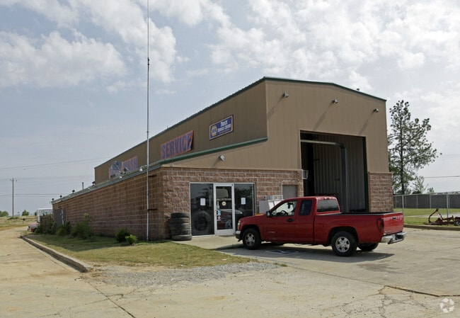
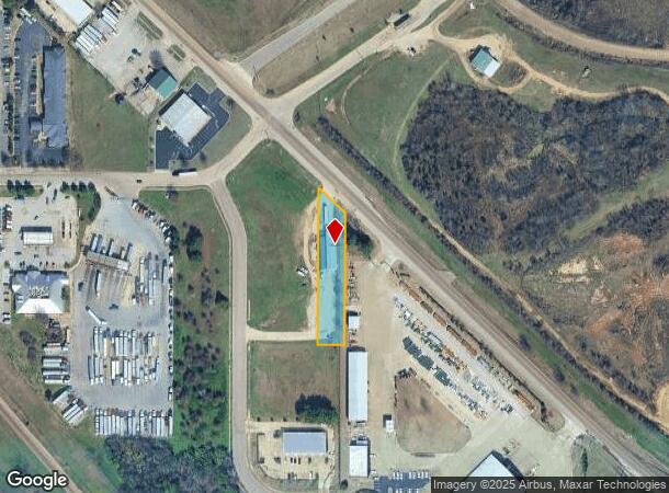
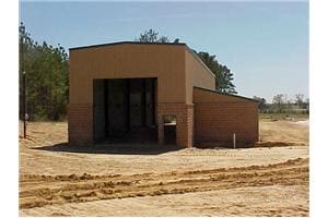
11207 Highway 178, Olive Branch, MS 38654
NEARBY LISTINGS FOR SALE OR LEASE
Property Detail
11207 Highway 178
Memphis, TN-MS-AR
Hacks Cross Business Center 2Nd Rev Lots
2061121000000800
HACKS CROSS BUSINESS CENTER REVISED LOTS 7 & 8 LOT 8
Realpropertynec
DeSoto
X
Mississippi
28033C0120G
8
2025
0.75 AC
2025
DeSoto
070830
Memphis
3,248 SF
DEMOGRAPHICS near 11207 Highway 178
1 mile
3 mile
5 mile
2024 Total Population
2,472
23,299
46,284
2029 Population
2,679
25,348
50,135
Pop Growth 2024-2029
+ 8.37%
+ 8.79%
+ 8.32%
Average Age
36
38
38
2024 Total Households
802
8,130
16,482
HH Growth 2024-2029
+ 8.35%
+ 8.81%
+ 8.26%
Median Household Inc
$87,314
$82,704
$81,768
Avg Household Size
2.90
2.80
2.80
2024 Avg HH Vehicles
2.00
2.00
2.00
Median Home Value
$247,837
$238,842
$251,292
Median Year Built
2002
1998
1999
Nearby Places
Map Layers
Map Styles
 Street
 Aerial
Transit
 Traffic
 Biking
Places
Listings with unknown addresses are not visible on the map
- Restaurants
- Banks
- Shops
- Fitness
- Groceries
PUBLIC TRANSPORTATION
AIRPORT
Memphis International
Drive
Walk
Distance
Memphis International
26 min
16.2 mi
Nearby Properties
Address
Land Use
TOTAL SIZE
Lot Size
Zoning
Address
Land Use
TOTAL SIZE
Lot Size
Zoning
1,150,296 SF
68.41 AC
M-1
Address
Land Use
TOTAL SIZE
Lot Size
Zoning
1,299,800 SF
50.22 AC
M-1
Address
Land Use
TOTAL SIZE
Lot Size
Zoning
860,464 SF
54.55 AC
M-1
Address
Land Use
TOTAL SIZE
Lot Size
Zoning
813,440 SF
38.72 AC
PB
Address
Land Use
TOTAL SIZE
Lot Size
Zoning
927,742 SF
42.73 AC
PB
Address
Land Use
TOTAL SIZE
Lot Size
Zoning
447,008 SF
28.41 AC
PB
Address
Land Use
TOTAL SIZE
Lot Size
Zoning
390,874 SF
122.03 AC
M-1
Address
Land Use
TOTAL SIZE
Lot Size
Zoning
599,752 SF
40.17 AC
M-1
Address
Land Use
TOTAL SIZE
Lot Size
Zoning
1,082,465 SF
57.74 AC
PB
Address
Land Use
TOTAL SIZE
Lot Size
Zoning
399,672 SF
19.97 AC
M-1
Address
Land Use
TOTAL SIZE
Lot Size
Zoning
413,028 SF
28.15 AC
M-1
Address
Land Use
TOTAL SIZE
Lot Size
Zoning
377,821 SF
22.08 AC
PB
Address
Land Use
TOTAL SIZE
Lot Size
Zoning
342,001 SF
33.28 AC
M-1
Address
Land Use
TOTAL SIZE
Lot Size
Zoning
301,365 SF
19.98 AC
M-2
Address
Land Use
TOTAL SIZE
Lot Size
Zoning
13,554 SF
15.32 AC
PUD
Address
Land Use
TOTAL SIZE
Lot Size
Zoning
11,097 SF
13.39 AC
PUD
Address
Land Use
TOTAL SIZE
Lot Size
Zoning
259,264 SF
14.31 AC
PB
Address
Land Use
TOTAL SIZE
Lot Size
Zoning
160,000 SF
17 AC
M-2
Address
Land Use
TOTAL SIZE
Lot Size
Zoning
267,880 SF
12.67 AC
PB
Address
Land Use
TOTAL SIZE
Lot Size
Zoning
293,248 SF
14.33 AC
PB
Address
Land Use
TOTAL SIZE
Lot Size
Zoning
12,770 SF
Address
Land Use
TOTAL SIZE
Lot Size
Zoning
160,240 SF
23.89 AC
M-2
Address
Land Use
TOTAL SIZE
Lot Size
Zoning
62,363 SF
12.78 AC
C-2
Address
Land Use
TOTAL SIZE
Lot Size
Zoning
119,796 SF
8.48 AC
M-1
Address
Land Use
TOTAL SIZE
Lot Size
Zoning
50,978 SF
2.96 AC
C-2
Address
Land Use
TOTAL SIZE
Lot Size
Zoning
36.77 AC
C-2
Address
Land Use
TOTAL SIZE
Lot Size
Zoning
66,281 SF
10.29 AC
M-1
Address
Land Use
TOTAL SIZE
Lot Size
Zoning
12,197 SF
1.34 AC
C-2
Address
Land Use
TOTAL SIZE
Lot Size
Zoning
10,154 SF
5.95 AC
C-4
Address
Land Use
TOTAL SIZE
Lot Size
Zoning
13,004 SF
5.51 AC
PUD
The World's #1 Commercial Real Estate Marketplace
Connect with us
© 2026 CoStar Group
The information above has been obtained from sources believed reliable. While we do not doubt its accuracy we have not verified it and make no guarantee, warranty or representation about it. It is your responsibility to independently confirm its accuracy and completeness. Any projections, opinions, assumptions, or estimates used are for example only and do not represent the current or future performance of the property. The value of this transaction to you depends on tax and other factors which should be evaluated by your tax, financial, and legal advisors. You and your advisors should conduct a careful, independent investigation of the property to determine to your satisfaction the suitability of the property for your needs.