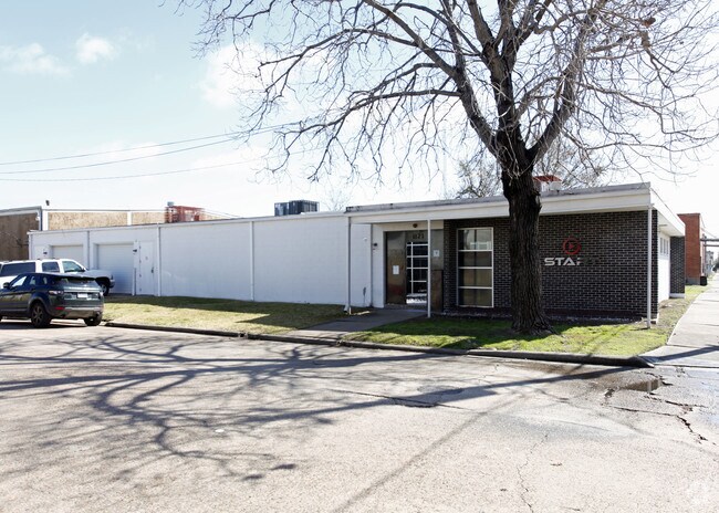
Property Record
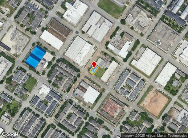
1121 Delano St, Houston, TX 77003
Current Lease Availabilities
NEARBY LISTINGS FOR SALE OR LEASE
Property Detail
1121 Delano St
0022270000013
South Side Of Buffalo Bayou
Warehouse
TRS 7A & 6A BLK 509 SSBB
X
Harris
48201C0880M
Texas
2024
0.13 AC
2025
Inner Loop East End
310200
Houston
4,443 SF
Houston-The Woodlands-Sugar Land, TX
DEMOGRAPHICS near 1121 Delano St
1 Mile
3 Mile
5 Mile
2024 Total Population
19,695
194,642
467,384
2029 Population
20,774
203,173
485,136
Pop Growth 2024-2029
+ 5.48%
+ 4.38%
+ 3.80%
Average Age
38
37
37
2024 Total Households
9,611
84,885
201,768
HH Growth 2024-2029
+ 5.63%
+ 4.85%
+ 4.09%
Median Household Inc
$78,992
$66,563
$67,675
Avg Household Size
1.90
2.00
2.10
2024 Avg HH Vehicles
1.00
1.00
2.00
Median Home Value
$337,859
$347,829
$358,011
Median Year Built
2009
1994
1987
Nearby Places
- Restaurants
- Banks
- Shops
- Fitness
- Groceries
PUBLIC TRANSPORTATION
TRANSIT/SUBWAY
Eado / Stadium Stn Eb (METRORAIL GREEN LINE - Metropolitan Transit Authority of Harris County, METRORAIL PURPLE LINE - Metropolitan Transit Authority of Harris County)
DRIVE
WALK
Distance
Eado / Stadium Stn Eb (METRORAIL GREEN LINE - Metropolitan Transit Authority of Harris County, METRORAIL PURPLE LINE - Metropolitan Transit Authority of Harris County)
2 min
13 min
0.7 mi
Leeland Third Ward Sb (METRORAIL PURPLE LINE - Metropolitan Transit Authority of Harris County)
DRIVE
WALK
Distance
Leeland Third Ward Sb (METRORAIL PURPLE LINE - Metropolitan Transit Authority of Harris County)
1 min
14 min
0.7 mi
Harrisburg Blvd (METRORAIL PURPLE LINE - Metropolitan Transit Authority of Harris County)
DRIVE
WALK
Distance
Harrisburg Blvd (METRORAIL PURPLE LINE - Metropolitan Transit Authority of Harris County)
2 min
16 min
0.8 mi
Coffee Plant / 2Nd Ward Eb (METRORAIL GREEN LINE - Metropolitan Transit Authority of Harris County, METRORAIL PURPLE LINE - Metropolitan Transit Authority of Harris County)
DRIVE
WALK
Distance
Coffee Plant / 2Nd Ward Eb (METRORAIL GREEN LINE - Metropolitan Transit Authority of Harris County, METRORAIL PURPLE LINE - Metropolitan Transit Authority of Harris County)
2 min
17 min
0.9 mi
Convention District Capitol Wb (METRORAIL GREEN LINE - Metropolitan Transit Authority of Harris County, METRORAIL PURPLE LINE - Metropolitan Transit Authority of Harris County)
DRIVE
WALK
Distance
Convention District Capitol Wb (METRORAIL GREEN LINE - Metropolitan Transit Authority of Harris County, METRORAIL PURPLE LINE - Metropolitan Transit Authority of Harris County)
2 min
17 min
0.9 mi
COMMUTER RAIL
Houston (Sunset Limited - Amtrak)
DRIVE
WALK
Distance
Houston (Sunset Limited - Amtrak)
6 min
2.4 mi
AIRPORT
William P Hobby
DRIVE
WALK
Distance
William P Hobby
21 min
10.8 mi
George Bush Intcntl/Houston
DRIVE
WALK
Distance
George Bush Intcntl/Houston
28 min
19.6 mi
Freight Ports
Port of Houston
DRIVE
WALK
Distance
Port of Houston
18 min
10.2 mi
Nearby Properties
Address
Land Use
TOTAL SIZE
Lot Size
Zoning
Address
Land Use
TOTAL SIZE
Lot Size
Zoning
1,383,720 SF
1.47 AC
Address
Land Use
TOTAL SIZE
Lot Size
Zoning
1,101,686 SF
1.45 AC
Address
Land Use
TOTAL SIZE
Lot Size
Zoning
973,861 SF
1.18 AC
Address
Land Use
TOTAL SIZE
Lot Size
Zoning
899,279 SF
1.18 AC
Address
Land Use
TOTAL SIZE
Lot Size
Zoning
797,208 SF
1.46 AC
Address
Land Use
TOTAL SIZE
Lot Size
Zoning
1,916,394 SF
1.46 AC
Address
Land Use
TOTAL SIZE
Lot Size
Zoning
1,871,418 SF
1.44 AC
Address
Land Use
TOTAL SIZE
Lot Size
Zoning
1,091,726 SF
2.60 AC
Address
Land Use
TOTAL SIZE
Lot Size
Zoning
1,232,364 SF
1.49 AC
Address
Land Use
TOTAL SIZE
Lot Size
Zoning
1,436,400 SF
1.44 AC
Address
Land Use
TOTAL SIZE
Lot Size
Zoning
1,321,033 SF
1.46 AC
Address
Land Use
TOTAL SIZE
Lot Size
Zoning
4,169,721 SF
31.23 AC
Address
Land Use
TOTAL SIZE
Lot Size
Zoning
2,005,097 SF
1.44 AC
Address
Land Use
TOTAL SIZE
Lot Size
Zoning
1,374,271 SF
1.44 AC
Address
Land Use
TOTAL SIZE
Lot Size
Zoning
1,150,681 SF
1.17 AC
Address
Land Use
TOTAL SIZE
Lot Size
Zoning
515,025 SF
1.50 AC
Address
Land Use
TOTAL SIZE
Lot Size
Zoning
1,657,484 SF
1.44 AC
Address
Land Use
TOTAL SIZE
Lot Size
Zoning
1,282,908 SF
2.74 AC
Address
Land Use
TOTAL SIZE
Lot Size
Zoning
1,311,133 SF
1.44 AC
Address
Land Use
TOTAL SIZE
Lot Size
Zoning
1,181,384 SF
1.47 AC
Address
Land Use
TOTAL SIZE
Lot Size
Zoning
1,162,204 SF
1.44 AC
Address
Land Use
TOTAL SIZE
Lot Size
Zoning
934,258 SF
1.45 AC
Address
Land Use
TOTAL SIZE
Lot Size
Zoning
1,103,424 SF
1.44 AC
Address
Land Use
TOTAL SIZE
Lot Size
Zoning
1,365,801 SF
1.44 AC
Address
Land Use
TOTAL SIZE
Lot Size
Zoning
1,017,783 SF
1.44 AC
Address
Land Use
TOTAL SIZE
Lot Size
Zoning
1,182,525 SF
1.11 AC
Address
Land Use
TOTAL SIZE
Lot Size
Zoning
608,233 SF
2.23 AC
Address
Land Use
TOTAL SIZE
Lot Size
Zoning
930,730 SF
1.89 AC
Address
Land Use
TOTAL SIZE
Lot Size
Zoning
612,078 SF
1.44 AC
Address
Land Use
TOTAL SIZE
Lot Size
Zoning
468,513 SF
0.86 AC
The World's #1 Commercial Real Estate Marketplace
Connect with us
© 2025 CoStar Group
The information above has been obtained from sources believed reliable. While we do not doubt its accuracy we have not verified it and make no guarantee, warranty or representation about it. It is your responsibility to independently confirm its accuracy and completeness. Any projections, opinions, assumptions, or estimates used are for example only and do not represent the current or future performance of the property. The value of this transaction to you depends on tax and other factors which should be evaluated by your tax, financial, and legal advisors. You and your advisors should conduct a careful, independent investigation of the property to determine to your satisfaction the suitability of the property for your needs.