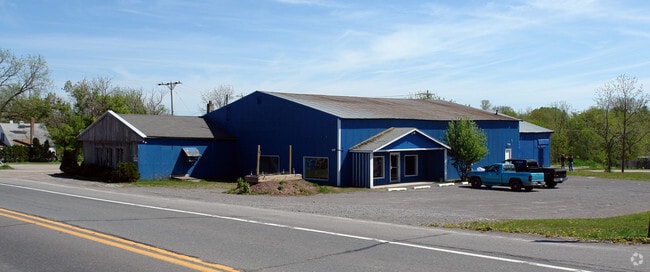
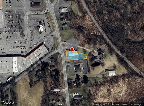
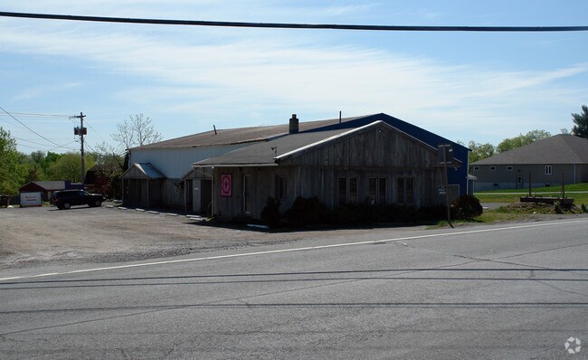
Property Record
1121 Glenwood Ave, Oneida, NY 13421
NEARBY LISTINGS FOR SALE OR LEASE
Property Detail
1121 Glenwood Ave
251289-038-074-0001-014-001-0000
Madison
Storesoffices
New York
X
14.001
36065C0659F
0.46 AC
2025
Madison County
2024
Syracuse
030102
Syracuse, NY
6,620 SF
DEMOGRAPHICS near 1121 Glenwood Ave
1 Mile
3 Mile
5 Mile
2024 Total Population
2,622
14,502
19,940
2029 Population
2,559
14,215
19,504
Pop Growth 2024-2029
(2.40%)
(1.98%)
(2.19%)
Average Age
45
44
43
2024 Total Households
1,151
6,300
8,466
HH Growth 2024-2029
(2.52%)
(2.13%)
(2.32%)
Median Household Inc
$68,946
$61,112
$64,079
Avg Household Size
2.20
2.20
2.30
2024 Avg HH Vehicles
2.00
2.00
2.00
Median Home Value
$159,821
$164,582
$162,825
Median Year Built
1948
1950
1954
Nearby Places
Map Layers
Map Styles
 Street
 Aerial
- Restaurants
- Banks
- Shops
- Fitness
- Groceries
PUBLIC TRANSPORTATION
AIRPORT
Syracuse Hancock International
DRIVE
WALK
Distance
Syracuse Hancock International
47 min
33.1 mi
Freight Ports
Albany, NY Port
DRIVE
WALK
Distance
Albany, NY Port
142 min
118.1 mi
SALE & LEASE HISTORY
LISTING DATE
SALE/LEASE

Oct 31, 2018
For Sale
Nearby Properties
Address
Land Use
TOTAL SIZE
Lot Size
Zoning
Address
Land Use
TOTAL SIZE
Lot Size
Zoning
132,207 SF
4.14 AC
CS
Address
Land Use
TOTAL SIZE
Lot Size
Zoning
71,138 SF
14.10 AC
CS
Address
Land Use
TOTAL SIZE
Lot Size
Zoning
26,158 SF
19.28 AC
LI
Address
Land Use
TOTAL SIZE
Lot Size
Zoning
1,252 SF
44.93 AC
R1
Address
Land Use
TOTAL SIZE
Lot Size
Zoning
183,164 SF
21.78 AC
C
Address
Land Use
TOTAL SIZE
Lot Size
Zoning
2,418 SF
55.37 AC
R1
Address
Land Use
TOTAL SIZE
Lot Size
Zoning
137,443 SF
26.45 AC
C
Address
Land Use
TOTAL SIZE
Lot Size
Zoning
29,762 SF
6.75 AC
C
Address
Land Use
TOTAL SIZE
Lot Size
Zoning
28,350 SF
142.35 AC
A
Address
Land Use
TOTAL SIZE
Lot Size
Zoning
Address
Land Use
TOTAL SIZE
Lot Size
Zoning
215,981 SF
12.90 AC
C
Address
Land Use
TOTAL SIZE
Lot Size
Zoning
49,029 SF
12 AC
CS
Address
Land Use
TOTAL SIZE
Lot Size
Zoning
19,251 SF
23.72 AC
LI
Address
Land Use
TOTAL SIZE
Lot Size
Zoning
21,150 SF
3.74 AC
Address
Land Use
TOTAL SIZE
Lot Size
Zoning
Address
Land Use
TOTAL SIZE
Lot Size
Zoning
61,969 SF
2.15 AC
C
Address
Land Use
TOTAL SIZE
Lot Size
Zoning
109,750 SF
12.98 AC
C
Address
Land Use
TOTAL SIZE
Lot Size
Zoning
82,953 SF
1.43 AC
C
Address
Land Use
TOTAL SIZE
Lot Size
Zoning
56,914 SF
3.83 AC
C
Address
Land Use
TOTAL SIZE
Lot Size
Zoning
205,242 SF
34.07 AC
Address
Land Use
TOTAL SIZE
Lot Size
Zoning
205,242 SF
46.75 AC
Address
Land Use
TOTAL SIZE
Lot Size
Zoning
205,242 SF
46.75 AC
Address
Land Use
TOTAL SIZE
Lot Size
Zoning
532 SF
20.48 AC
CS
Address
Land Use
TOTAL SIZE
Lot Size
Zoning
17,600 SF
2.76 AC
R2
Address
Land Use
TOTAL SIZE
Lot Size
Zoning
4.66 AC
C
Address
Land Use
TOTAL SIZE
Lot Size
Zoning
29,848 SF
2.78 AC
C
Address
Land Use
TOTAL SIZE
Lot Size
Zoning
33,675 SF
6.50 AC
01 - NOT Z
Address
Land Use
TOTAL SIZE
Lot Size
Zoning
33,675 SF
6.50 AC
01 - NOT Z
Address
Land Use
TOTAL SIZE
Lot Size
Zoning
48.42 AC
Address
Land Use
TOTAL SIZE
Lot Size
Zoning
246,600 SF
48.42 AC
01 - NOT Z
The World's #1 Commercial Real Estate Marketplace
Connect with us
© 2025 CoStar Group
The information above has been obtained from sources believed reliable. While we do not doubt its accuracy we have not verified it and make no guarantee, warranty or representation about it. It is your responsibility to independently confirm its accuracy and completeness. Any projections, opinions, assumptions, or estimates used are for example only and do not represent the current or future performance of the property. The value of this transaction to you depends on tax and other factors which should be evaluated by your tax, financial, and legal advisors. You and your advisors should conduct a careful, independent investigation of the property to determine to your satisfaction the suitability of the property for your needs.