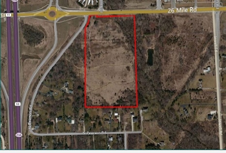
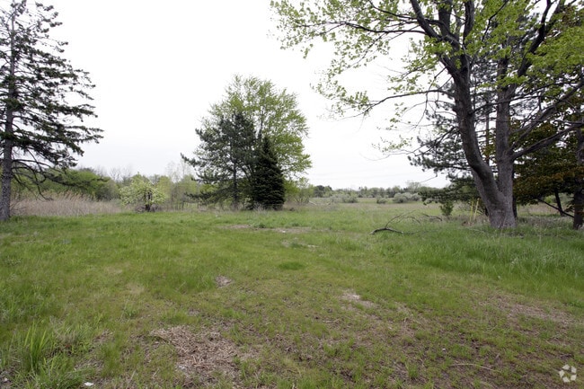
Property Record
11210 26 Mile Rd, Shelby Township, MI 48315

This Property Is For Sale
NEARBY LISTINGS FOR SALE OR LEASE
Property Detail
11210 26 Mile Rd
Detroit-Warren-Dearborn, MI
Supervisors Plat
23-07-03-201-009
L 1A2 SUPERVISORS PLAT OF MOROWSKE FARM LOT 1 EXC, BEG AT NW COR OF LOT 1, TH N 88 DEG 23' 25" E 77.15 FT ALG N LINE OF LOT
Commercialacreage
Macomb
AE
Michigan
26099C0209H
1
2025
18.87 AC
2025
Macomb West
226700
Detroit
850 SF
DEMOGRAPHICS near 11210 26 Mile Rd
1 Mile
3 Mile
5 Mile
2024 Total Population
5,944
48,080
114,582
2029 Population
5,911
47,744
113,492
Pop Growth 2024-2029
(0.56%)
(0.70%)
(0.95%)
Average Age
39
42
42
2024 Total Households
2,253
18,208
42,507
HH Growth 2024-2029
(0.62%)
(0.68%)
(1.03%)
Median Household Inc
$72,559
$97,758
$100,253
Avg Household Size
2.60
2.60
2.70
2024 Avg HH Vehicles
2.00
2.00
2.00
Median Home Value
$260,927
$378,305
$354,512
Median Year Built
1995
1994
1994
Nearby Places
Map Layers
Map Styles
 Street
 Aerial
- Restaurants
- Banks
- Shops
- Fitness
- Groceries
PUBLIC TRANSPORTATION
AIRPORT
Windsor International
DRIVE
WALK
Distance
Windsor International
67 min
42.1 mi
Nearby Properties
Address
Land Use
TOTAL SIZE
Lot Size
Zoning
Address
Land Use
TOTAL SIZE
Lot Size
Zoning
371,520 SF
21.91 AC
CK MAP
Address
Land Use
TOTAL SIZE
Lot Size
Zoning
13.61 AC
C-2
Address
Land Use
TOTAL SIZE
Lot Size
Zoning
257,878 SF
30 AC
Address
Land Use
TOTAL SIZE
Lot Size
Zoning
29,394 SF
33.83 AC
CK MAP
Address
Land Use
TOTAL SIZE
Lot Size
Zoning
181,725 SF
CK MAP
Address
Land Use
TOTAL SIZE
Lot Size
Zoning
160,104 SF
22.65 AC
CONSENT-R1
Address
Land Use
TOTAL SIZE
Lot Size
Zoning
90,185 SF
14.73 AC
C2
Address
Land Use
TOTAL SIZE
Lot Size
Zoning
224,323 SF
22.15 AC
C-3
Address
Land Use
TOTAL SIZE
Lot Size
Zoning
10.28 AC
CK MAP
Address
Land Use
TOTAL SIZE
Lot Size
Zoning
9.47 AC
R-9
Address
Land Use
TOTAL SIZE
Lot Size
Zoning
217,654 SF
26.88 AC
CONSENT-GC
Address
Land Use
TOTAL SIZE
Lot Size
Zoning
117,856 SF
13.51 AC
C-3
Address
Land Use
TOTAL SIZE
Lot Size
Zoning
234,542 SF
37.18 AC
LM
Address
Land Use
TOTAL SIZE
Lot Size
Zoning
8.81 AC
C-6
Address
Land Use
TOTAL SIZE
Lot Size
Zoning
128,299 SF
6.92 AC
V1
Address
Land Use
TOTAL SIZE
Lot Size
Zoning
118,844 SF
17.80 AC
C-2
Address
Land Use
TOTAL SIZE
Lot Size
Zoning
134,400 SF
7.55 AC
CK MAP
Address
Land Use
TOTAL SIZE
Lot Size
Zoning
108,799 SF
25.03 AC
CONSENT-R1
Address
Land Use
TOTAL SIZE
Lot Size
Zoning
960 SF
18.63 AC
R-8
Address
Land Use
TOTAL SIZE
Lot Size
Zoning
188,047 SF
24.76 AC
RM2
Address
Land Use
TOTAL SIZE
Lot Size
Zoning
125,426 SF
11.87 AC
R-1-B
Address
Land Use
TOTAL SIZE
Lot Size
Zoning
122,540 SF
CK MAP
Address
Land Use
TOTAL SIZE
Lot Size
Zoning
90,519 SF
4.12 AC
V1
Address
Land Use
TOTAL SIZE
Lot Size
Zoning
74,354 SF
10.62 AC
C3
Address
Land Use
TOTAL SIZE
Lot Size
Zoning
152,601 SF
13.90 AC
RM2
Address
Land Use
TOTAL SIZE
Lot Size
Zoning
95,977 SF
4.24 AC
V1
Address
Land Use
TOTAL SIZE
Lot Size
Zoning
61,573 SF
6.96 AC
C-3
Address
Land Use
TOTAL SIZE
Lot Size
Zoning
9.84 AC
R-9
Address
Land Use
TOTAL SIZE
Lot Size
Zoning
29.03 AC
CK MAP
Address
Land Use
TOTAL SIZE
Lot Size
Zoning
194,122 SF
19.28 AC
V1
The World's #1 Commercial Real Estate Marketplace
Connect with us
© 2026 CoStar Group
The information above has been obtained from sources believed reliable. While we do not doubt its accuracy we have not verified it and make no guarantee, warranty or representation about it. It is your responsibility to independently confirm its accuracy and completeness. Any projections, opinions, assumptions, or estimates used are for example only and do not represent the current or future performance of the property. The value of this transaction to you depends on tax and other factors which should be evaluated by your tax, financial, and legal advisors. You and your advisors should conduct a careful, independent investigation of the property to determine to your satisfaction the suitability of the property for your needs.