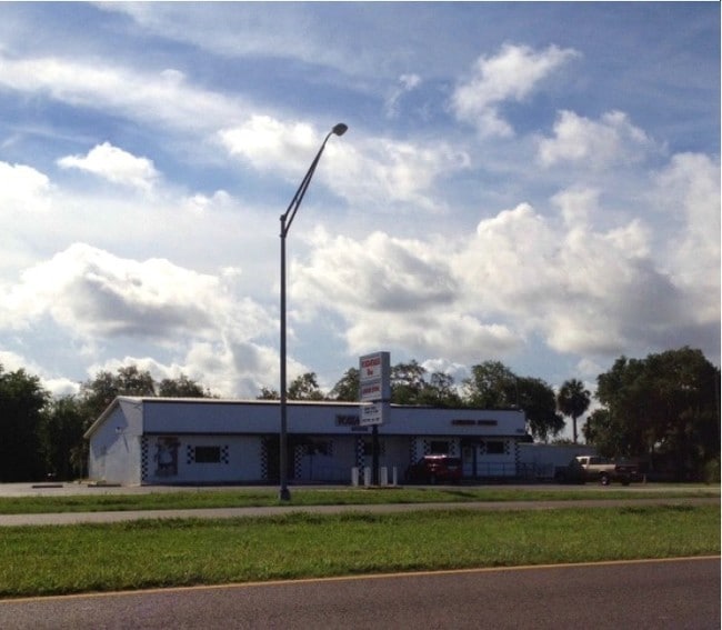
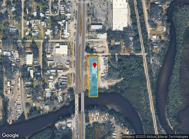
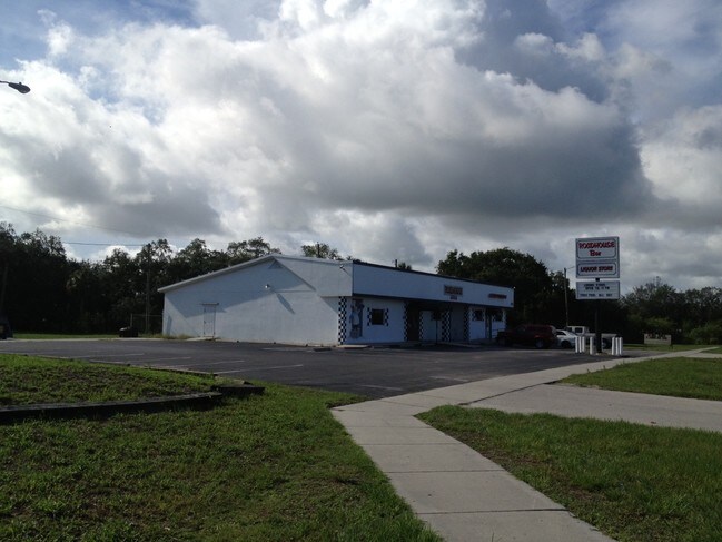
Property Record
11210 S Us Highway 41 Hwy, Gibsonton, FL 33534
NEARBY LISTINGS FOR SALE OR LEASE
Property Detail
11210 S Us Highway 41 Hwy
Tampa-St. Petersburg-Clearwater, FL
Unplatted
U-26-30-19-ZZZ-000001-72610.0
BEGIN AT SW COR OF LOT 59 REV MAP FLORIDA GARDENLANDS RUN ELY 18 FT FOR POB THENCE SLY 188 FT MOL TO TIDAL WATERS OF BULL FROG CREEK THENCE NELY TO A POINT 115 FT E OF W BDRY OF LOT 59 THENCE NLY 158 FT MOL TO POINT ON S BDRY OF LOT 59 WLY 97 FT TO P
Bartavern
Hillsborough
AE
Florida
12057C0484J
59
2024
1.05 AC
2024
Southeast Hillsborough
013804
Tampa/St Petersburg
5,110 SF
DEMOGRAPHICS near 11210 S Us Highway 41 Hwy
1 Mile
3 Mile
5 Mile
2024 Total Population
5,660
32,793
123,440
2029 Population
6,220
36,205
136,228
Pop Growth 2024-2029
+ 9.89%
+ 10.40%
+ 10.36%
Average Age
35
35
37
2024 Total Households
1,829
11,205
44,457
HH Growth 2024-2029
+ 10.11%
+ 10.63%
+ 10.59%
Median Household Inc
$69,326
$77,358
$79,450
Avg Household Size
3.00
2.90
2.70
2024 Avg HH Vehicles
2.00
2.00
2.00
Median Home Value
$244,106
$259,444
$273,000
Median Year Built
1997
2006
2006
Nearby Places
Map Layers
Map Styles
 Street
 Aerial
- Restaurants
- Banks
- Shops
- Fitness
- Groceries
PUBLIC TRANSPORTATION
AIRPORT
Tampa International
DRIVE
WALK
Distance
Tampa International
32 min
20.4 mi
St Pete-Clearwater International
DRIVE
WALK
Distance
St Pete-Clearwater International
49 min
29.6 mi
Freight Ports
Port of Tampa Bay
DRIVE
WALK
Distance
Port of Tampa Bay
16 min
9.7 mi
Nearby Properties
Address
Land Use
TOTAL SIZE
Lot Size
Zoning
Address
Land Use
TOTAL SIZE
Lot Size
Zoning
399,150 SF
26.32 AC
PD
Address
Land Use
TOTAL SIZE
Lot Size
Zoning
370,924 SF
73.35 AC
PD
Address
Land Use
TOTAL SIZE
Lot Size
Zoning
628,730 SF
952.72 AC
M
Address
Land Use
TOTAL SIZE
Lot Size
Zoning
347,147 SF
258.94 AC
PD
Address
Land Use
TOTAL SIZE
Lot Size
Zoning
425,231 SF
23.78 AC
M
Address
Land Use
TOTAL SIZE
Lot Size
Zoning
124,865 SF
20.14 AC
PD
Address
Land Use
TOTAL SIZE
Lot Size
Zoning
146,440 SF
18.56 AC
PD
Address
Land Use
TOTAL SIZE
Lot Size
Zoning
48,968 SF
10 AC
PD
Address
Land Use
TOTAL SIZE
Lot Size
Zoning
520,366 SF
122.24 AC
PD
Address
Land Use
TOTAL SIZE
Lot Size
Zoning
215,929 SF
26.74 AC
PD
Address
Land Use
TOTAL SIZE
Lot Size
Zoning
110,148 SF
23.04 AC
M
Address
Land Use
TOTAL SIZE
Lot Size
Zoning
924 SF
563.45 AC
AR
Address
Land Use
TOTAL SIZE
Lot Size
Zoning
40,676 SF
8.56 AC
M
Address
Land Use
TOTAL SIZE
Lot Size
Zoning
101,880 SF
6.53 AC
PD
Address
Land Use
TOTAL SIZE
Lot Size
Zoning
35,795 SF
48.06 AC
AI
Address
Land Use
TOTAL SIZE
Lot Size
Zoning
72,298 SF
9.58 AC
PD
Address
Land Use
TOTAL SIZE
Lot Size
Zoning
122.18 AC
PD
Address
Land Use
TOTAL SIZE
Lot Size
Zoning
87,068 SF
24.86 AC
PD
Address
Land Use
TOTAL SIZE
Lot Size
Zoning
54,892 SF
2.57 AC
PD
Address
Land Use
TOTAL SIZE
Lot Size
Zoning
327.61 AC
AR
Address
Land Use
TOTAL SIZE
Lot Size
Zoning
83,235 SF
21.40 AC
M
Address
Land Use
TOTAL SIZE
Lot Size
Zoning
290.36 AC
AI
Address
Land Use
TOTAL SIZE
Lot Size
Zoning
0.37 AC
PD
Address
Land Use
TOTAL SIZE
Lot Size
Zoning
21,780 SF
2.39 AC
PD
Address
Land Use
TOTAL SIZE
Lot Size
Zoning
83,301 SF
9.99 AC
PD
Address
Land Use
TOTAL SIZE
Lot Size
Zoning
79.33 AC
RMC-6
Address
Land Use
TOTAL SIZE
Lot Size
Zoning
94,078 SF
10.68 AC
AR
Address
Land Use
TOTAL SIZE
Lot Size
Zoning
2,267 SF
72.57 AC
AR
Address
Land Use
TOTAL SIZE
Lot Size
Zoning
70,162 SF
5.39 AC
CG
Address
Land Use
TOTAL SIZE
Lot Size
Zoning
22,946 SF
4.77 AC
ASC-1
The World's #1 Commercial Real Estate Marketplace
Connect with us
© 2025 CoStar Group
The information above has been obtained from sources believed reliable. While we do not doubt its accuracy we have not verified it and make no guarantee, warranty or representation about it. It is your responsibility to independently confirm its accuracy and completeness. Any projections, opinions, assumptions, or estimates used are for example only and do not represent the current or future performance of the property. The value of this transaction to you depends on tax and other factors which should be evaluated by your tax, financial, and legal advisors. You and your advisors should conduct a careful, independent investigation of the property to determine to your satisfaction the suitability of the property for your needs.