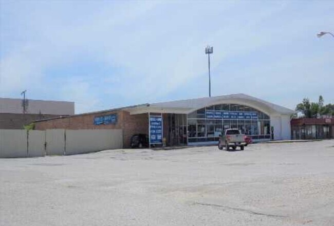
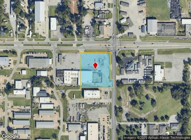
Property Record
11212 E Admiral Pl, Tulsa, OK 74116

NEARBY LISTINGS FOR SALE OR LEASE
Property Detail
11212 E Admiral Pl
Tulsa, OK
Unplatted
99406-94-06-18300
N427 E368.4 GOV LT 8 LESS N75 & E50 S352 N427 FOR ST SEC 6 19 14 2.57ACS
Storebuilding
Tulsa
X
Oklahoma
40131C0350J
8
2025
2.57 AC
2025
East Tulsa
008900
Tulsa
15,192 SF
DEMOGRAPHICS near 11212 E Admiral Pl
1 Mile
3 Mile
5 Mile
2024 Total Population
8,104
57,895
134,479
2029 Population
8,447
59,887
139,024
Pop Growth 2024-2029
+ 4.23%
+ 3.44%
+ 3.38%
Average Age
36
35
36
2024 Total Households
2,976
21,133
51,871
HH Growth 2024-2029
+ 4.30%
+ 3.55%
+ 3.44%
Median Household Inc
$43,266
$44,176
$46,159
Avg Household Size
2.60
2.60
2.50
2024 Avg HH Vehicles
2.00
2.00
2.00
Median Home Value
$81,400
$104,674
$125,074
Median Year Built
1967
1970
1968
Nearby Places
Map Layers
Map Styles
 Street
 Aerial
- Restaurants
- Banks
- Shops
- Fitness
- Groceries
PUBLIC TRANSPORTATION
AIRPORT
Tulsa International
DRIVE
WALK
Distance
Tulsa International
13 min
7.6 mi
Freight Ports
Tulsa Port Of Catoosa
DRIVE
WALK
Distance
Tulsa Port Of Catoosa
16 min
10.8 mi
Nearby Properties
Address
Land Use
TOTAL SIZE
Lot Size
Zoning
Address
Land Use
TOTAL SIZE
Lot Size
Zoning
350,741 SF
28.01 AC
CS
Address
Land Use
TOTAL SIZE
Lot Size
Zoning
349,823 SF
203.39 AC
IL
Address
Land Use
TOTAL SIZE
Lot Size
Zoning
228.59 AC
IL
Address
Land Use
TOTAL SIZE
Lot Size
Zoning
725,973 SF
122.30 AC
IM
Address
Land Use
TOTAL SIZE
Lot Size
Zoning
77,346 SF
8.59 AC
RS3
Address
Land Use
TOTAL SIZE
Lot Size
Zoning
112,556 SF
11.07 AC
CH
Address
Land Use
TOTAL SIZE
Lot Size
Zoning
103,248 SF
8.87 AC
IL
Address
Land Use
TOTAL SIZE
Lot Size
Zoning
97.68 AC
CH
Address
Land Use
TOTAL SIZE
Lot Size
Zoning
106,270 SF
9.47 AC
RM0
Address
Land Use
TOTAL SIZE
Lot Size
Zoning
124,648 SF
21.23 AC
IL
Address
Land Use
TOTAL SIZE
Lot Size
Zoning
62,352 SF
4.88 AC
CS
Address
Land Use
TOTAL SIZE
Lot Size
Zoning
66,324 SF
12.85 AC
CS
Address
Land Use
TOTAL SIZE
Lot Size
Zoning
101,090 SF
1.70 AC
RS2
Address
Land Use
TOTAL SIZE
Lot Size
Zoning
40,626 SF
2.25 AC
CS
Address
Land Use
TOTAL SIZE
Lot Size
Zoning
55,425 SF
2.96 AC
IL
Address
Land Use
TOTAL SIZE
Lot Size
Zoning
28,465 SF
6.71 AC
RS3
Address
Land Use
TOTAL SIZE
Lot Size
Zoning
24,113 SF
3.54 AC
CS
Address
Land Use
TOTAL SIZE
Lot Size
Zoning
56,531 SF
7.79 AC
RS3
Address
Land Use
TOTAL SIZE
Lot Size
Zoning
498,836 SF
50.22 AC
CS
Address
Land Use
TOTAL SIZE
Lot Size
Zoning
49,953 SF
2.36 AC
OL
Address
Land Use
TOTAL SIZE
Lot Size
Zoning
30,291 SF
4.49 AC
AG
Address
Land Use
TOTAL SIZE
Lot Size
Zoning
673,050 SF
52.77 AC
IM
Address
Land Use
TOTAL SIZE
Lot Size
Zoning
18,325 SF
3.05 AC
CS
Address
Land Use
TOTAL SIZE
Lot Size
Zoning
75.35 AC
AG
Address
Land Use
TOTAL SIZE
Lot Size
Zoning
40,202 SF
2.93 AC
RM0
Address
Land Use
TOTAL SIZE
Lot Size
Zoning
609,418 SF
49.83 AC
IM
Address
Land Use
TOTAL SIZE
Lot Size
Zoning
293,564 SF
23.75 AC
RM1
Address
Land Use
TOTAL SIZE
Lot Size
Zoning
14,237 SF
2.28 AC
CS
The World's #1 Commercial Real Estate Marketplace
Connect with us
© 2025 CoStar Group
The information above has been obtained from sources believed reliable. While we do not doubt its accuracy we have not verified it and make no guarantee, warranty or representation about it. It is your responsibility to independently confirm its accuracy and completeness. Any projections, opinions, assumptions, or estimates used are for example only and do not represent the current or future performance of the property. The value of this transaction to you depends on tax and other factors which should be evaluated by your tax, financial, and legal advisors. You and your advisors should conduct a careful, independent investigation of the property to determine to your satisfaction the suitability of the property for your needs.