Property Record
1114 Cranston Rd, Beloit, WI 53511
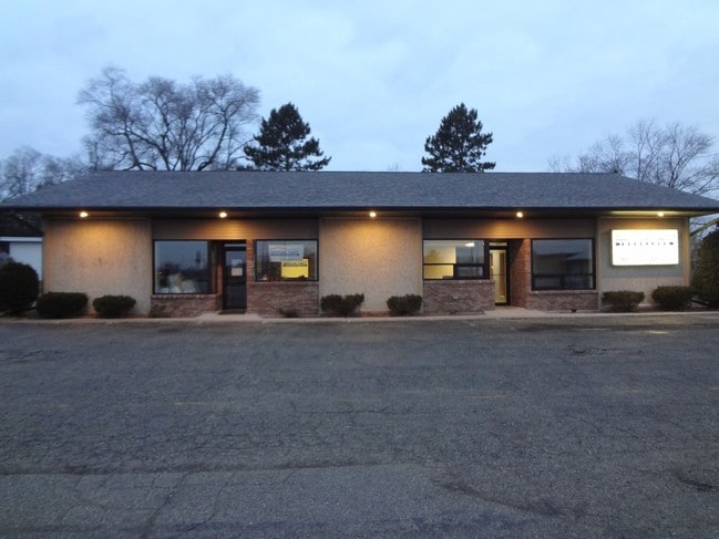


Property Detail
1114 Cranston Rd
Janesville-Beloit, WI
PT SW1/4 ASSESSOR'S PLAT PT OUTLOT 7 COM 394.7' W OF CEN SEC, S 158.7', W 111.1', N 158.6', E 111.47' TO POB (EXC 33' RD)
623-145
ROCK
Commercialnec
Wisconsin
B and X Area of moderate flood hazard, usually the area between the limits of the 100-year and 500-year floods.
0.32 AC
2025
Rock County
2025
Milwaukee/Madison
002300
NEARBY LISTINGS FOR SALE OR LEASE
DEMOGRAPHICS near 1114 Cranston Rd
1 mile
3 mile
5 mile
2024 Total Population
8,820
43,539
60,864
2029 Population
8,831
43,881
61,503
Pop Growth 2024-2029
+ 0.12%
+ 0.79%
+ 1.05%
Average Age
41
39
40
2024 Total Households
3,578
16,995
23,773
HH Growth 2024-2029
+ 0.06%
+ 0.81%
+ 1.06%
Median Household Inc
$58,470
$61,257
$67,558
Avg Household Size
2.40
2.40
2.40
2024 Avg HH Vehicles
2.00
2.00
2.00
Median Home Value
$164,446
$174,343
$182,017
Median Year Built
1960
1958
1965
Nearby Places
Map Layers
Map Styles
 Street
 Aerial
Transit
 Traffic
 Biking
Places
Listings with unknown addresses are not visible on the map
- Restaurants
- Banks
- Shops
- Fitness
- Groceries
PUBLIC TRANSPORTATION
AIRPORT
Chicago/Rockford International
Drive
Walk
Distance
Chicago/Rockford International
48 min
34.5 mi
Freight Ports
Port Milwaukee
Drive
Walk
Distance
Port Milwaukee
87 min
73.3 mi
SALE & LEASE HISTORY
LISTING DATE
SALE/LEASE

Jan 06, 2020
For Lease
Feb 26, 2018
For Lease
Nearby Properties
Address
Land Use
TOTAL SIZE
Lot Size
Zoning
Address
Land Use
TOTAL SIZE
Lot Size
Zoning
264,000 SF
34 AC
Address
Land Use
TOTAL SIZE
Lot Size
Zoning
19.64 AC
CHI
Address
Land Use
TOTAL SIZE
Lot Size
Zoning
39.83 AC
Address
Land Use
TOTAL SIZE
Lot Size
Zoning
24.76 AC
Address
Land Use
TOTAL SIZE
Lot Size
Zoning
36,860 SF
11.26 AC
Address
Land Use
TOTAL SIZE
Lot Size
Zoning
202,676 SF
19.31 AC
Address
Land Use
TOTAL SIZE
Lot Size
Zoning
61,820 SF
5.63 AC
Address
Land Use
TOTAL SIZE
Lot Size
Zoning
103,761 SF
21.67 AC
Address
Land Use
TOTAL SIZE
Lot Size
Zoning
7.71 AC
Address
Land Use
TOTAL SIZE
Lot Size
Zoning
400,014 SF
43.71 AC
Address
Land Use
TOTAL SIZE
Lot Size
Zoning
186,691 SF
17.06 AC
Address
Land Use
TOTAL SIZE
Lot Size
Zoning
3.39 AC
Address
Land Use
TOTAL SIZE
Lot Size
Zoning
3.47 AC
Address
Land Use
TOTAL SIZE
Lot Size
Zoning
233,850 SF
30.40 AC
Address
Land Use
TOTAL SIZE
Lot Size
Zoning
3.65 AC
Address
Land Use
TOTAL SIZE
Lot Size
Zoning
13.21 AC
Address
Land Use
TOTAL SIZE
Lot Size
Zoning
231,166 SF
19.25 AC
Address
Land Use
TOTAL SIZE
Lot Size
Zoning
361,947 SF
23.26 AC
Address
Land Use
TOTAL SIZE
Lot Size
Zoning
24.15 AC
Address
Land Use
TOTAL SIZE
Lot Size
Zoning
193,013 SF
22.93 AC
Address
Land Use
TOTAL SIZE
Lot Size
Zoning
38,012 SF
2.74 AC
Address
Land Use
TOTAL SIZE
Lot Size
Zoning
40,800 SF
81.29 AC
Address
Land Use
TOTAL SIZE
Lot Size
Zoning
22.90 AC
Address
Land Use
TOTAL SIZE
Lot Size
Zoning
100,000 SF
14.78 AC
Address
Land Use
TOTAL SIZE
Lot Size
Zoning
27.69 AC
Address
Land Use
TOTAL SIZE
Lot Size
Zoning
16.81 AC
Address
Land Use
TOTAL SIZE
Lot Size
Zoning
10.33 AC
Address
Land Use
TOTAL SIZE
Lot Size
Zoning
30,000 SF
3.31 AC
Address
Land Use
TOTAL SIZE
Lot Size
Zoning
101,660 SF
10.14 AC
Address
Land Use
TOTAL SIZE
Lot Size
Zoning
16,336 SF
9.06 AC
The World's #1 Commercial Real Estate Marketplace
Connect with us
© 2026 CoStar Group
The information above has been obtained from sources believed reliable. While we do not doubt its accuracy we have not verified it and make no guarantee, warranty or representation about it. It is your responsibility to independently confirm its accuracy and completeness. Any projections, opinions, assumptions, or estimates used are for example only and do not represent the current or future performance of the property. The value of this transaction to you depends on tax and other factors which should be evaluated by your tax, financial, and legal advisors. You and your advisors should conduct a careful, independent investigation of the property to determine to your satisfaction the suitability of the property for your needs.