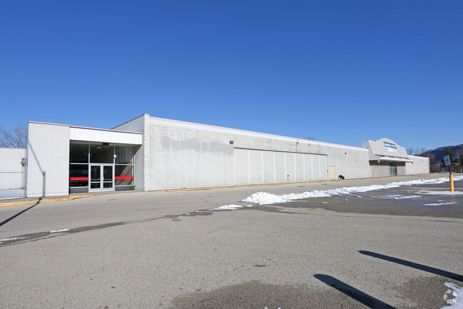
Property Record
1122 W Highway 61, Winona, MN 55987


NEARBY LISTINGS FOR SALE OR LEASE
Property Detail
1122 W Highway 61
Winona, MN
Limits
32.320.5530
SECT-28 TWP-107 RANGE-007 LIMITS 6.91 AC IN NE 1/4 AS PER MF #269111 (K-MART) EX: THAT PART W 1/2 NE 1/4 NW COR NE 1/4
Commercialnec
Winona
2024
Minnesota
2025
6.42 AC
670302
Minnesota South Area
89,010 SF
Other Market Areas
DEMOGRAPHICS near 1122 W Highway 61
1 Mile
3 Mile
5 Mile
2024 Total Population
8,931
28,132
33,300
2029 Population
8,899
28,062
33,249
Pop Growth 2024-2029
(0.36%)
(0.25%)
(0.15%)
Average Age
36
38
39
2024 Total Households
3,213
11,606
13,764
HH Growth 2024-2029
(0.50%)
(0.29%)
(0.19%)
Median Household Inc
$58,168
$51,744
$53,719
Avg Household Size
2.10
2.10
2.10
2024 Avg HH Vehicles
2.00
2.00
2.00
Median Home Value
$169,269
$173,006
$181,983
Median Year Built
1948
1961
1966
Nearby Places
Map Layers
Map Styles
 Street
 Aerial
- Restaurants
- Banks
- Shops
- Fitness
- Groceries
PUBLIC TRANSPORTATION
COMMUTER RAIL
DRIVE
WALK
Distance
5 min
1.8 mi
AIRPORT
La Crosse Regional
DRIVE
WALK
Distance
La Crosse Regional
36 min
28.4 mi
SALE & LEASE HISTORY
LISTING DATE
SALE/LEASE

May 15, 2017
For Sale
May 11, 2017
For Lease
May 11, 2017
For Sale
Mar 08, 2018
For Lease
Apr 06, 2017
For Sale
Nearby Properties
Address
Land Use
TOTAL SIZE
Lot Size
Zoning
Address
Land Use
TOTAL SIZE
Lot Size
Zoning
93,261 SF
27.29 AC
Address
Land Use
TOTAL SIZE
Lot Size
Zoning
99,918 SF
35.30 AC
Address
Land Use
TOTAL SIZE
Lot Size
Zoning
125,217 SF
13.36 AC
Address
Land Use
TOTAL SIZE
Lot Size
Zoning
86,366 SF
7.16 AC
Address
Land Use
TOTAL SIZE
Lot Size
Zoning
151,850 SF
37.50 AC
Address
Land Use
TOTAL SIZE
Lot Size
Zoning
40,985 SF
1.93 AC
Address
Land Use
TOTAL SIZE
Lot Size
Zoning
45,720 SF
4.10 AC
Address
Land Use
TOTAL SIZE
Lot Size
Zoning
135,516 SF
21.90 AC
Address
Land Use
TOTAL SIZE
Lot Size
Zoning
37,149 SF
4.90 AC
Address
Land Use
TOTAL SIZE
Lot Size
Zoning
49,336 SF
2.07 AC
Address
Land Use
TOTAL SIZE
Lot Size
Zoning
166,348 SF
7.81 AC
Address
Land Use
TOTAL SIZE
Lot Size
Zoning
37,149 SF
1.50 AC
Address
Land Use
TOTAL SIZE
Lot Size
Zoning
47,928 SF
4.37 AC
Address
Land Use
TOTAL SIZE
Lot Size
Zoning
94,590 SF
3.80 AC
Address
Land Use
TOTAL SIZE
Lot Size
Zoning
244,816 SF
3.69 AC
Address
Land Use
TOTAL SIZE
Lot Size
Zoning
157,152 SF
3.92 AC
Address
Land Use
TOTAL SIZE
Lot Size
Zoning
199,094 SF
22.74 AC
Address
Land Use
TOTAL SIZE
Lot Size
Zoning
205,592 SF
19.45 AC
Address
Land Use
TOTAL SIZE
Lot Size
Zoning
19,000 SF
2.07 AC
Address
Land Use
TOTAL SIZE
Lot Size
Zoning
63,868 SF
4.53 AC
Address
Land Use
TOTAL SIZE
Lot Size
Zoning
95,456 SF
0.85 AC
Address
Land Use
TOTAL SIZE
Lot Size
Zoning
20,040 SF
1.24 AC
Address
Land Use
TOTAL SIZE
Lot Size
Zoning
37,488 SF
1.78 AC
Address
Land Use
TOTAL SIZE
Lot Size
Zoning
26,864 SF
1.76 AC
Address
Land Use
TOTAL SIZE
Lot Size
Zoning
16,668 SF
2.07 AC
Address
Land Use
TOTAL SIZE
Lot Size
Zoning
162,258 SF
14.79 AC
Address
Land Use
TOTAL SIZE
Lot Size
Zoning
104,500 SF
2.30 AC
Address
Land Use
TOTAL SIZE
Lot Size
Zoning
18,834 SF
0.81 AC
Address
Land Use
TOTAL SIZE
Lot Size
Zoning
166,105 SF
2 AC
The World's #1 Commercial Real Estate Marketplace
Connect with us
© 2025 CoStar Group
The information above has been obtained from sources believed reliable. While we do not doubt its accuracy we have not verified it and make no guarantee, warranty or representation about it. It is your responsibility to independently confirm its accuracy and completeness. Any projections, opinions, assumptions, or estimates used are for example only and do not represent the current or future performance of the property. The value of this transaction to you depends on tax and other factors which should be evaluated by your tax, financial, and legal advisors. You and your advisors should conduct a careful, independent investigation of the property to determine to your satisfaction the suitability of the property for your needs.