Property Record
11220 Georgia Ave, Silver Spring, MD 20902
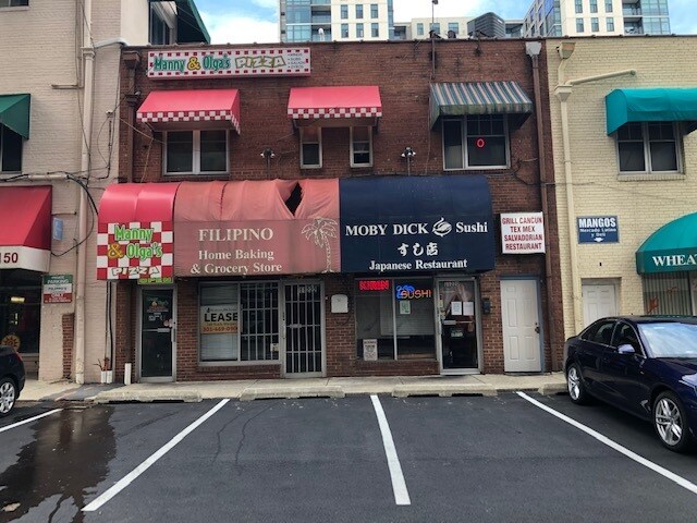


Property Detail
11220 Georgia Ave
13-01187142
TRIANGLE PARK
Restaurantbuilding
Montgomery
CR6.0
Maryland
B and X Area of moderate flood hazard, usually the area between the limits of the 100-year and 500-year floods.
24
2024
0.10 AC
2025
Kensington/Wheaton
703800
Washington, DC
2,400 SF
Washington-Arlington-Alexandria, DC-VA-MD-WV
NEARBY LISTINGS FOR SALE OR LEASE
DEMOGRAPHICS near 11220 Georgia Ave
1 mile
3 mile
5 mile
2025 Total Population
26,863
165,382
495,083
2030 Population
27,803
169,911
510,325
Pop Growth 2025-2030
+ 3.50%
+ 2.74%
+ 3.08%
Average Age
39
40
41
2025 Total Households
9,553
55,967
186,861
HH Growth 2025-2030
+ 3.50%
+ 2.77%
+ 3.27%
Median Household Inc
$110,066
$126,896
$116,072
Avg Household Size
2.70
2.80
2.50
2025 Avg HH Vehicles
2.00
2.00
2.00
Median Home Value
$605,444
$646,929
$646,942
Median Year Built
1966
1960
1967
Nearby Places
Map Layers
Map Styles
 Street
 Aerial
Transit
 Traffic
 Biking
Places
Listings with unknown addresses are not visible on the map
- Restaurants
- Banks
- Shops
- Fitness
- Groceries
PUBLIC TRANSPORTATION
TRANSIT/SUBWAY
Wheaton (Red Line - Washington Metropolitan Area Transit Authority Metrorail (Metrorail))
Drive
Walk
Distance
Wheaton (Red Line - Washington Metropolitan Area Transit Authority Metrorail (Metrorail))
1 min
3 min
0.1 mi
COMMUTER RAIL
Drive
Walk
Distance
7 min
2.1 mi
Drive
Walk
Distance
10 min
3.3 mi
AIRPORT
Ronald Reagan Washington Ntl
Drive
Walk
Distance
Ronald Reagan Washington Ntl
29 min
15.1 mi
Washington Dulles International
Drive
Walk
Distance
Washington Dulles International
47 min
29.9 mi
Baltimore/Washington International Thurgood Marshall
Drive
Walk
Distance
Baltimore/Washington International Thurgood Marshall
44 min
32.2 mi
Freight Ports
Port of Baltimore
Drive
Walk
Distance
Port of Baltimore
47 min
34.9 mi
SALE & LEASE HISTORY
LISTING DATE
SALE/LEASE

Sep 25, 2016
For Lease
Mar 10, 2023
For Lease
Nearby Properties
Address
Land Use
TOTAL SIZE
Lot Size
Zoning
Address
Land Use
TOTAL SIZE
Lot Size
Zoning
775,490 SF
14.21 AC
R60
Address
Land Use
TOTAL SIZE
Lot Size
Zoning
1,775,186 SF
75.19 AC
GR1.5
Address
Land Use
TOTAL SIZE
Lot Size
Zoning
178,124 SF
11 AC
R60
Address
Land Use
TOTAL SIZE
Lot Size
Zoning
626,132 SF
7.28 AC
CR0.5
Address
Land Use
TOTAL SIZE
Lot Size
Zoning
487,112 SF
3.19 AC
CR3.0
Address
Land Use
TOTAL SIZE
Lot Size
Zoning
431,630 SF
25.77 AC
R60
Address
Land Use
TOTAL SIZE
Lot Size
Zoning
364,000 SF
CR6.0
Address
Land Use
TOTAL SIZE
Lot Size
Zoning
379,878 SF
2.13 AC
CR
Address
Land Use
TOTAL SIZE
Lot Size
Zoning
454,275 SF
1.12 AC
CR7.2
Address
Land Use
TOTAL SIZE
Lot Size
Zoning
386,567 SF
29.70 AC
R60
Address
Land Use
TOTAL SIZE
Lot Size
Zoning
460,492 SF
3.56 AC
CR4.0
Address
Land Use
TOTAL SIZE
Lot Size
Zoning
276,462 SF
15.11 AC
R60
Address
Land Use
TOTAL SIZE
Lot Size
Zoning
244,934 SF
3.59 AC
CRT2.
Address
Land Use
TOTAL SIZE
Lot Size
Zoning
164,307 SF
16.45 AC
R90
Address
Land Use
TOTAL SIZE
Lot Size
Zoning
664,858 SF
106.79 AC
R90
Address
Land Use
TOTAL SIZE
Lot Size
Zoning
160,000 SF
27.97 AC
R90
Address
Land Use
TOTAL SIZE
Lot Size
Zoning
540,807 SF
8.73 AC
RH
Address
Land Use
TOTAL SIZE
Lot Size
Zoning
187,691 SF
3.03 AC
R90
Address
Land Use
TOTAL SIZE
Lot Size
Zoning
427,500 SF
25.70 AC
R30
Address
Land Use
TOTAL SIZE
Lot Size
Zoning
352,334 SF
1.66 AC
CR4.0
Address
Land Use
TOTAL SIZE
Lot Size
Zoning
249,858 SF
12.39 AC
CRT1.
Address
Land Use
TOTAL SIZE
Lot Size
Zoning
215,937 SF
2.91 AC
CR2.0
Address
Land Use
TOTAL SIZE
Lot Size
Zoning
124,896 SF
0.37 AC
CR6.0
Address
Land Use
TOTAL SIZE
Lot Size
Zoning
321,840 SF
13.95 AC
R20
Address
Land Use
TOTAL SIZE
Lot Size
Zoning
163,463 SF
13.38 AC
R90
Address
Land Use
TOTAL SIZE
Lot Size
Zoning
661,981 SF
8.30 AC
CR3.0
Address
Land Use
TOTAL SIZE
Lot Size
Zoning
89,863 SF
17.47 AC
IM2.5
Address
Land Use
TOTAL SIZE
Lot Size
Zoning
192,407 SF
15.02 AC
CR3.0
Address
Land Use
TOTAL SIZE
Lot Size
Zoning
332,133 SF
28.24 AC
R90
Address
Land Use
TOTAL SIZE
Lot Size
Zoning
336,300 SF
2.59 AC
CR2.5
The World's #1 Commercial Real Estate Marketplace
Connect with us
© 2026 CoStar Group
The information above has been obtained from sources believed reliable. While we do not doubt its accuracy we have not verified it and make no guarantee, warranty or representation about it. It is your responsibility to independently confirm its accuracy and completeness. Any projections, opinions, assumptions, or estimates used are for example only and do not represent the current or future performance of the property. The value of this transaction to you depends on tax and other factors which should be evaluated by your tax, financial, and legal advisors. You and your advisors should conduct a careful, independent investigation of the property to determine to your satisfaction the suitability of the property for your needs.