Property Record
11220 N Harrells Ferry Rd, Baton Rouge, LA 70816

Current Lease Availabilities
NEARBY LISTINGS FOR SALE OR LEASE
Property Detail
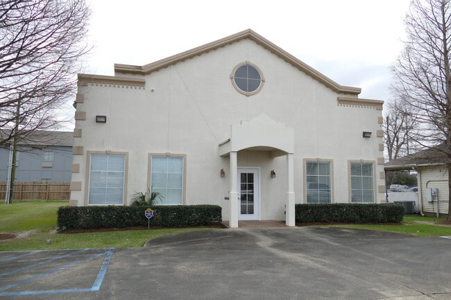
11220 N Harrells Ferry Rd
Baton Rouge, LA
Baywood Office Park
01958747
WARD: 1-4, SUBDIVISION: BAYWOOD OFFICE PARK, LOT: 18-A-1. LOT 18-A-1 RESUB. OF LOTS 19 & 18-A, OF A RESUB. OF LOTS 18 & 17-A, BATWOOD OFFICE PARK.RESUB. 1994-99-2001.
Storesoffices
E Baton Rouge
X
Louisiana
22033C0270E
18-a
2024
0.30 AC
2024
Florida/Airline
003909
Baton Rouge
2,500 SF
DEMOGRAPHICS near 11220 N Harrells Ferry Rd
1 Mile
3 Mile
5 Mile
2024 Total Population
14,923
85,803
179,968
2029 Population
14,842
84,054
176,216
Pop Growth 2024-2029
(0.54%)
(2.04%)
(2.08%)
Average Age
36
39
39
2024 Total Households
6,280
35,764
74,971
HH Growth 2024-2029
(0.56%)
(2.16%)
(2.13%)
Median Household Inc
$47,159
$58,993
$58,715
Avg Household Size
2.30
2.30
2.30
2024 Avg HH Vehicles
2.00
2.00
2.00
Median Home Value
$202,891
$218,039
$228,773
Median Year Built
1986
1981
1983
Nearby Places
Map Layers
Map Styles
 Street
 Aerial
- Restaurants
- Banks
- Shops
- Fitness
- Groceries
PUBLIC TRANSPORTATION
AIRPORT
Baton Rouge Metro Ryan Field
DRIVE
WALK
Distance
Baton Rouge Metro Ryan Field
18 min
10.0 mi
Freight Ports
Port of Greater Baton Rouge
DRIVE
WALK
Distance
Port of Greater Baton Rouge
19 min
11.7 mi
Nearby Properties
Address
Land Use
TOTAL SIZE
Lot Size
Zoning
Address
Land Use
TOTAL SIZE
Lot Size
Zoning
291,999 SF
51.31 AC
Address
Land Use
TOTAL SIZE
Lot Size
Zoning
365,566 SF
8.77 AC
Address
Land Use
TOTAL SIZE
Lot Size
Zoning
501,688 SF
11.17 AC
Address
Land Use
TOTAL SIZE
Lot Size
Zoning
234,743 SF
4.69 AC
Address
Land Use
TOTAL SIZE
Lot Size
Zoning
375,748 SF
25.58 AC
Address
Land Use
TOTAL SIZE
Lot Size
Zoning
281,736 SF
13.13 AC
Address
Land Use
TOTAL SIZE
Lot Size
Zoning
Address
Land Use
TOTAL SIZE
Lot Size
Zoning
481,760 SF
18.31 AC
Address
Land Use
TOTAL SIZE
Lot Size
Zoning
20.12 AC
Address
Land Use
TOTAL SIZE
Lot Size
Zoning
Address
Land Use
TOTAL SIZE
Lot Size
Zoning
126,717 SF
56.29 AC
Address
Land Use
TOTAL SIZE
Lot Size
Zoning
74,847 SF
9.96 AC
Address
Land Use
TOTAL SIZE
Lot Size
Zoning
362,253 SF
34.85 AC
Address
Land Use
TOTAL SIZE
Lot Size
Zoning
Address
Land Use
TOTAL SIZE
Lot Size
Zoning
98,912 SF
13.75 AC
Address
Land Use
TOTAL SIZE
Lot Size
Zoning
287,310 SF
5.19 AC
Address
Land Use
TOTAL SIZE
Lot Size
Zoning
216,000 SF
7.32 AC
Address
Land Use
TOTAL SIZE
Lot Size
Zoning
186,400 SF
9.13 AC
Address
Land Use
TOTAL SIZE
Lot Size
Zoning
Address
Land Use
TOTAL SIZE
Lot Size
Zoning
Address
Land Use
TOTAL SIZE
Lot Size
Zoning
Address
Land Use
TOTAL SIZE
Lot Size
Zoning
223,498 SF
20.34 AC
Address
Land Use
TOTAL SIZE
Lot Size
Zoning
110,151 SF
16.28 AC
Address
Land Use
TOTAL SIZE
Lot Size
Zoning
Address
Land Use
TOTAL SIZE
Lot Size
Zoning
Address
Land Use
TOTAL SIZE
Lot Size
Zoning
Address
Land Use
TOTAL SIZE
Lot Size
Zoning
55,824 SF
4.03 AC
Address
Land Use
TOTAL SIZE
Lot Size
Zoning
288,746 SF
12.16 AC
Address
Land Use
TOTAL SIZE
Lot Size
Zoning
152,156 SF
1.53 AC
Address
Land Use
TOTAL SIZE
Lot Size
Zoning
25.54 AC
The World's #1 Commercial Real Estate Marketplace
Connect with us
© 2025 CoStar Group
The information above has been obtained from sources believed reliable. While we do not doubt its accuracy we have not verified it and make no guarantee, warranty or representation about it. It is your responsibility to independently confirm its accuracy and completeness. Any projections, opinions, assumptions, or estimates used are for example only and do not represent the current or future performance of the property. The value of this transaction to you depends on tax and other factors which should be evaluated by your tax, financial, and legal advisors. You and your advisors should conduct a careful, independent investigation of the property to determine to your satisfaction the suitability of the property for your needs.