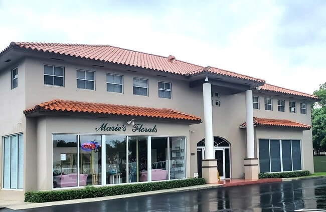
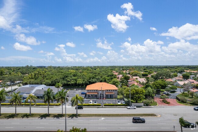
Property Record
11220 N Kendall Dr, Miami, FL 33176

NEARBY LISTINGS FOR SALE OR LEASE
Property Detail
11220 N Kendall Dr
30-5006-000-0642
Acreage
Cemetery
6 55 40 1.527 AC M/L N 255.02FT OF E1/2 OF E1/2 OF NE1/4 OF NW1/4 LESS E35FT FOR R/W &N255.02 OF E33.65 OF W1/2 OF E1/2 OF NE1/4 OF NW1/4 & LESS N55FT OR 19794-4834 0601 5
X
Miami/Dade
12086C0442L
Florida
2024
1.53 AC
2025
Kendall
008421
South Florida
16,829 SF
Miami-Miami Beach-Kendall, FL
DEMOGRAPHICS near 11220 N Kendall Dr
1 Mile
3 Mile
5 Mile
2024 Total Population
18,337
142,484
420,533
2029 Population
17,734
137,965
408,552
Pop Growth 2024-2029
(3.29%)
(3.17%)
(2.85%)
Average Age
45
43
43
2024 Total Households
6,970
50,327
143,384
HH Growth 2024-2029
(3.92%)
(3.59%)
(3.21%)
Median Household Inc
$66,510
$74,836
$72,076
Avg Household Size
2.50
2.70
2.80
2024 Avg HH Vehicles
2.00
2.00
2.00
Median Home Value
$377,019
$389,782
$394,412
Median Year Built
1981
1978
1981
Nearby Places
Map Layers
Map Styles
 Street
 Aerial
- Restaurants
- Banks
- Shops
- Fitness
- Groceries
PUBLIC TRANSPORTATION
COMMUTER RAIL
Dadeland South (Metrorail Green Line - Miami-Dade Transit (Metrorail/Metromover))
DRIVE
WALK
Distance
Dadeland South (Metrorail Green Line - Miami-Dade Transit (Metrorail/Metromover))
8 min
4.3 mi
Dadeland North (Metrorail Green Line - Miami-Dade Transit (Metrorail/Metromover))
DRIVE
WALK
Distance
Dadeland North (Metrorail Green Line - Miami-Dade Transit (Metrorail/Metromover))
9 min
5.2 mi
AIRPORT
Miami International
DRIVE
WALK
Distance
Miami International
23 min
12.4 mi
Fort Lauderdale/Hollywood International
DRIVE
WALK
Distance
Fort Lauderdale/Hollywood International
50 min
39.0 mi
Freight Ports
Port of Miami
DRIVE
WALK
Distance
Port of Miami
31 min
16.8 mi
SALE & LEASE HISTORY
LISTING DATE
SALE/LEASE

Jul 22, 2020
For Lease
Jul 15, 2024
For Lease
Jul 11, 2024
For Lease
Jan 16, 2025
For Lease
Nearby Properties
Address
Land Use
TOTAL SIZE
Lot Size
Zoning
Address
Land Use
TOTAL SIZE
Lot Size
Zoning
1,018,683 SF
11.46 AC
5000
Address
Land Use
TOTAL SIZE
Lot Size
Zoning
1,527,515 SF
55.17 AC
5000
Address
Land Use
TOTAL SIZE
Lot Size
Zoning
1,335,151 SF
180 AC
0100
Address
Land Use
TOTAL SIZE
Lot Size
Zoning
766,093 SF
8.91 AC
5000
Address
Land Use
TOTAL SIZE
Lot Size
Zoning
332,017 SF
6400
Address
Land Use
TOTAL SIZE
Lot Size
Zoning
333,947 SF
21.32 AC
6400
Address
Land Use
TOTAL SIZE
Lot Size
Zoning
407,900 SF
18.79 AC
3900
Address
Land Use
TOTAL SIZE
Lot Size
Zoning
382,043 SF
14.96 AC
3900
Address
Land Use
TOTAL SIZE
Lot Size
Zoning
350,948 SF
22.42 AC
3800
Address
Land Use
TOTAL SIZE
Lot Size
Zoning
30,297 SF
19.11 AC
6200
Address
Land Use
TOTAL SIZE
Lot Size
Zoning
245,376 SF
27 AC
6400
Address
Land Use
TOTAL SIZE
Lot Size
Zoning
196,806 SF
158.17 AC
8900
Address
Land Use
TOTAL SIZE
Lot Size
Zoning
367,374 SF
9.89 AC
8900
Address
Land Use
TOTAL SIZE
Lot Size
Zoning
313,755 SF
5 AC
2300
Address
Land Use
TOTAL SIZE
Lot Size
Zoning
183,845 SF
18.77 AC
5000
Address
Land Use
TOTAL SIZE
Lot Size
Zoning
276,202 SF
13.46 AC
3800
Address
Land Use
TOTAL SIZE
Lot Size
Zoning
192,585 SF
11.66 AC
6400
Address
Land Use
TOTAL SIZE
Lot Size
Zoning
228,254 SF
10.80 AC
3800
Address
Land Use
TOTAL SIZE
Lot Size
Zoning
116,627 SF
74.78 AC
8900
Address
Land Use
TOTAL SIZE
Lot Size
Zoning
291,110 SF
13.38 AC
3800
Address
Land Use
TOTAL SIZE
Lot Size
Zoning
237,857 SF
9.09 AC
2300
Address
Land Use
TOTAL SIZE
Lot Size
Zoning
249,202 SF
29.49 AC
8900
Address
Land Use
TOTAL SIZE
Lot Size
Zoning
283,695 SF
9.22 AC
3900
Address
Land Use
TOTAL SIZE
Lot Size
Zoning
19,382 SF
130 AC
8900
Address
Land Use
TOTAL SIZE
Lot Size
Zoning
175,184 SF
12.41 AC
6200
Address
Land Use
TOTAL SIZE
Lot Size
Zoning
188,499 SF
13.67 AC
6400
Address
Land Use
TOTAL SIZE
Lot Size
Zoning
227,540 SF
10.64 AC
3800
Address
Land Use
TOTAL SIZE
Lot Size
Zoning
281,931 SF
31.78 AC
3800
Address
Land Use
TOTAL SIZE
Lot Size
Zoning
191,632 SF
13.97 AC
6200
Address
Land Use
TOTAL SIZE
Lot Size
Zoning
230,128 SF
9 AC
3800
The World's #1 Commercial Real Estate Marketplace
Connect with us
© 2025 CoStar Group
The information above has been obtained from sources believed reliable. While we do not doubt its accuracy we have not verified it and make no guarantee, warranty or representation about it. It is your responsibility to independently confirm its accuracy and completeness. Any projections, opinions, assumptions, or estimates used are for example only and do not represent the current or future performance of the property. The value of this transaction to you depends on tax and other factors which should be evaluated by your tax, financial, and legal advisors. You and your advisors should conduct a careful, independent investigation of the property to determine to your satisfaction the suitability of the property for your needs.