Property Record
11220 Wright Rd, Lynwood, CA 90262
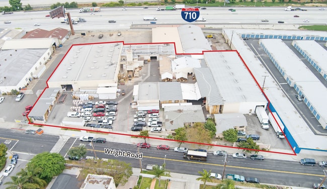

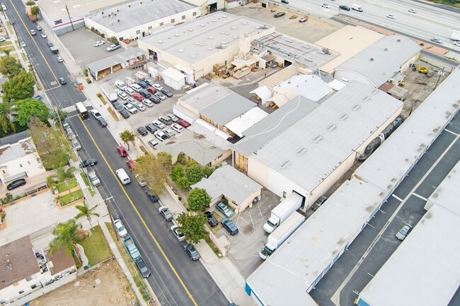

This Property Is For Sale
Property Detail
11220 Wright Rd
6194-030-010
SAN ANTONIO RANCHO 2.17 MORE OR LESS ACS ON SE LINE OF WRIGHT RD PER CS8484 COM NE THEREON 280.5 FT FROM N LINE OF C H WATTS LAND TH S 83 30 E 254.09 FT TH N 11 5226 E 115.12 FT TH S 84 4034 E W TO SD SE LINE TH SW THEREON TO BEG
Lightindustrial
Los Angeles
LYM1-M2*
California
2024
1.96 AC
2025
Downey/Paramount
540000
Los Angeles
16,262 SF
Los Angeles-Long Beach-Glendale, CA
NEARBY LISTINGS FOR SALE OR LEASE
DEMOGRAPHICS near 11220 Wright Rd
1 mile
3 mile
5 mile
2025 Total Population
27,631
315,359
868,561
2030 Population
27,259
309,522
851,991
Pop Growth 2025-2030
(1.35%)
(1.85%)
(1.91%)
Average Age
37
37
37
2025 Total Households
6,734
80,893
230,938
HH Growth 2025-2030
(1.44%)
(2.06%)
(2.14%)
Median Household Inc
$78,480
$72,011
$71,947
Avg Household Size
4.00
3.70
3.60
2025 Avg HH Vehicles
2.00
2.00
2.00
Median Home Value
$679,207
$678,863
$683,672
Median Year Built
1953
1957
1957
Nearby Places
Map Layers
Map Styles
 Street
 Aerial
Transit
 Traffic
 Biking
Places
Listings with unknown addresses are not visible on the map
- Restaurants
- Banks
- Shops
- Fitness
- Groceries
PUBLIC TRANSPORTATION
COMMUTER RAIL
Commerce (91 Line - Southern California Regional Rail Authority (Metrolink), Orange County Line - Southern California Regional Rail Authority (Metrolink))
Drive
Walk
Distance
Commerce (91 Line - Southern California Regional Rail Authority (Metrolink), Orange County Line - Southern California Regional Rail Authority (Metrolink))
14 min
6.8 mi
Montebello/Commerce (Riverside Line - Southern California Regional Rail Authority (Metrolink))
Drive
Walk
Distance
Montebello/Commerce (Riverside Line - Southern California Regional Rail Authority (Metrolink))
17 min
8.3 mi
AIRPORT
Long Beach (Daugherty Field)
Drive
Walk
Distance
Long Beach (Daugherty Field)
17 min
9.4 mi
Los Angeles International
Drive
Walk
Distance
Los Angeles International
23 min
15.5 mi
Bob Hope
Drive
Walk
Distance
Bob Hope
39 min
28.3 mi
Freight Ports
Port of Long Beach
Drive
Walk
Distance
Port of Long Beach
19 min
12.3 mi
Nearby Properties
Address
Land Use
TOTAL SIZE
Lot Size
Zoning
Address
Land Use
TOTAL SIZE
Lot Size
Zoning
1,339,758 SF
28.53 AC
DOM2-P*
Address
Land Use
TOTAL SIZE
Lot Size
Zoning
587,291 SF
11.42 AC
LYHMD*
Address
Land Use
TOTAL SIZE
Lot Size
Zoning
313,224 SF
4.41 AC
SGM2*
Address
Land Use
TOTAL SIZE
Lot Size
Zoning
556,348 SF
26.38 AC
PAM2
Address
Land Use
TOTAL SIZE
Lot Size
Zoning
323,368 SF
15.18 AC
LYM*
Address
Land Use
TOTAL SIZE
Lot Size
Zoning
51,000 SF
27.18 AC
SGM3
Address
Land Use
TOTAL SIZE
Lot Size
Zoning
248,925 SF
10.91 AC
LYCB1*
Address
Land Use
TOTAL SIZE
Lot Size
Zoning
332,504 SF
7.76 AC
DOHM
Address
Land Use
TOTAL SIZE
Lot Size
Zoning
37,867 SF
8.32 AC
COMH-B*
Address
Land Use
TOTAL SIZE
Lot Size
Zoning
200,043 SF
8.68 AC
LYM*
Address
Land Use
TOTAL SIZE
Lot Size
Zoning
43,406 SF
5.67 AC
SGM2
Address
Land Use
TOTAL SIZE
Lot Size
Zoning
105,586 SF
9.96 AC
SGM3*
Address
Land Use
TOTAL SIZE
Lot Size
Zoning
298,629 SF
6.93 AC
BGMPD*
Address
Land Use
TOTAL SIZE
Lot Size
Zoning
106,028 SF
6.42 AC
DOM2-P*
Address
Land Use
TOTAL SIZE
Lot Size
Zoning
378,720 SF
13.08 AC
SGM3*
Address
Land Use
TOTAL SIZE
Lot Size
Zoning
97,218 SF
9.64 AC
SGM2
Address
Land Use
TOTAL SIZE
Lot Size
Zoning
498,163 SF
11.53 AC
LYM*
Address
Land Use
TOTAL SIZE
Lot Size
Zoning
196,676 SF
9.80 AC
SGM3
Address
Land Use
TOTAL SIZE
Lot Size
Zoning
99,674 SF
6.53 AC
DOM2-P*
Address
Land Use
TOTAL SIZE
Lot Size
Zoning
150,115 SF
10.50 AC
SGM2
Address
Land Use
TOTAL SIZE
Lot Size
Zoning
97,600 SF
4.93 AC
CUM2*
Address
Land Use
TOTAL SIZE
Lot Size
Zoning
97,200 SF
4.81 AC
BGMPD*
Address
Land Use
TOTAL SIZE
Lot Size
Zoning
155,384 SF
11.59 AC
DOM2-P*
Address
Land Use
TOTAL SIZE
Lot Size
Zoning
183,128 SF
10.77 AC
PAM2*
Address
Land Use
TOTAL SIZE
Lot Size
Zoning
111,746 SF
4.38 AC
DOM2-P*
Address
Land Use
TOTAL SIZE
Lot Size
Zoning
149,723 SF
9.90 AC
LBIG
Address
Land Use
TOTAL SIZE
Lot Size
Zoning
97,204 SF
4.10 AC
COMH*
Address
Land Use
TOTAL SIZE
Lot Size
Zoning
49,763 SF
5.72 AC
SGCM*
Address
Land Use
TOTAL SIZE
Lot Size
Zoning
77,168 SF
2.90 AC
DOR3-P*
Address
Land Use
TOTAL SIZE
Lot Size
Zoning
105,229 SF
2.08 AC
PACM*
The World's #1 Commercial Real Estate Marketplace
Connect with us
© 2026 CoStar Group
The information above has been obtained from sources believed reliable. While we do not doubt its accuracy we have not verified it and make no guarantee, warranty or representation about it. It is your responsibility to independently confirm its accuracy and completeness. Any projections, opinions, assumptions, or estimates used are for example only and do not represent the current or future performance of the property. The value of this transaction to you depends on tax and other factors which should be evaluated by your tax, financial, and legal advisors. You and your advisors should conduct a careful, independent investigation of the property to determine to your satisfaction the suitability of the property for your needs.