Property Record
11221 Lochwood Blvd, Dallas, TX 75218
NEARBY LISTINGS FOR SALE OR LEASE
Property Detail
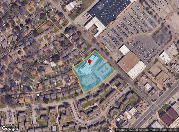
11221 Lochwood Blvd
Dallas-Fort Worth-Arlington, TX
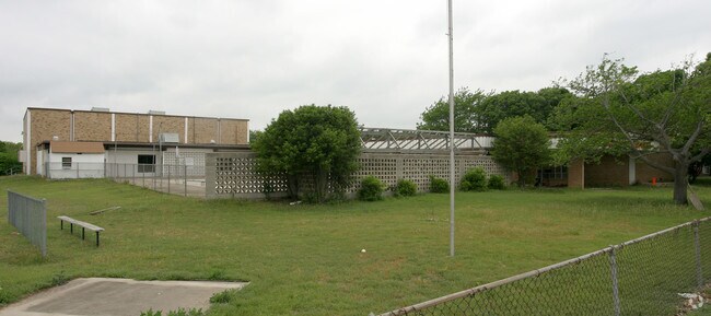
Lochwood Branch Library
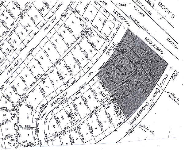
005364000508A0000
LOCHWOOD BRANCH LIBRARY BLK 5/5364 LT 8A LESS ROW ACS 2.802 INT 200600197187 DD05242006 CO-DC 5364 005 08A00 3DA5364 005
Governmentalpublicusegeneral
Dallas
X
Texas
48113C0355K
8a
0
2.80 AC
2025
Northeast Dallas
012802
Dallas/Ft Worth
20,512 SF
DEMOGRAPHICS near 11221 Lochwood Blvd
1 Mile
3 Mile
5 Mile
2024 Total Population
15,553
124,071
389,324
2029 Population
15,317
122,590
385,846
Pop Growth 2024-2029
(1.52%)
(1.19%)
(0.89%)
Average Age
38
37
36
2024 Total Households
5,689
46,051
151,595
HH Growth 2024-2029
(1.74%)
(1.33%)
(0.93%)
Median Household Inc
$64,915
$59,702
$57,913
Avg Household Size
2.70
2.60
2.50
2024 Avg HH Vehicles
2.00
2.00
2.00
Median Home Value
$308,777
$290,729
$279,577
Median Year Built
1958
1967
1974
Nearby Places
Map Layers
Map Styles
 Street
 Aerial
- Restaurants
- Banks
- Shops
- Fitness
- Groceries
PUBLIC TRANSPORTATION
AIRPORT
Dallas Love Field
DRIVE
WALK
Distance
Dallas Love Field
27 min
13.4 mi
Dallas-Fort Worth International
DRIVE
WALK
Distance
Dallas-Fort Worth International
38 min
29.6 mi
Nearby Properties
Address
Land Use
TOTAL SIZE
Lot Size
Zoning
Address
Land Use
TOTAL SIZE
Lot Size
Zoning
32,530 SF
0.02 AC
Z239
Address
Land Use
TOTAL SIZE
Lot Size
Zoning
351,901 SF
11.84 AC
Z239
Address
Land Use
TOTAL SIZE
Lot Size
Zoning
392,842 SF
16.79 AC
Z164
Address
Land Use
TOTAL SIZE
Lot Size
Zoning
691,816 SF
19.50 AC
Z239
Address
Land Use
TOTAL SIZE
Lot Size
Zoning
491,903 SF
22.48 AC
Z164
Address
Land Use
TOTAL SIZE
Lot Size
Zoning
391,774 SF
3.97 AC
Z239
Address
Land Use
TOTAL SIZE
Lot Size
Zoning
445,781 SF
4.57 AC
Z239
Address
Land Use
TOTAL SIZE
Lot Size
Zoning
245,023 SF
6.84 AC
Z164
Address
Land Use
TOTAL SIZE
Lot Size
Zoning
247,421 SF
3.96 AC
Z133
Address
Land Use
TOTAL SIZE
Lot Size
Zoning
284,990 SF
24.80 AC
Z298
Address
Land Use
TOTAL SIZE
Lot Size
Zoning
922,851 SF
52.30 AC
Z144
Address
Land Use
TOTAL SIZE
Lot Size
Zoning
480,000 SF
25.27 AC
Z239
Address
Land Use
TOTAL SIZE
Lot Size
Zoning
472,244 SF
25.25 AC
Z144
Address
Land Use
TOTAL SIZE
Lot Size
Zoning
292,827 SF
13.81 AC
Z163
Address
Land Use
TOTAL SIZE
Lot Size
Zoning
531,950 SF
24.62 AC
Z239
Address
Land Use
TOTAL SIZE
Lot Size
Zoning
349,156 SF
10.86 AC
Z59
Address
Land Use
TOTAL SIZE
Lot Size
Zoning
922,851 SF
52.28 AC
Z144
Address
Land Use
TOTAL SIZE
Lot Size
Zoning
121,440 SF
17.02 AC
Z298
Address
Land Use
TOTAL SIZE
Lot Size
Zoning
195,495 SF
9.61 AC
Z298
Address
Land Use
TOTAL SIZE
Lot Size
Zoning
265,986 SF
13.75 AC
Z163
Address
Land Use
TOTAL SIZE
Lot Size
Zoning
161,796 SF
14.84 AC
Z239
Address
Land Use
TOTAL SIZE
Lot Size
Zoning
244,575 SF
9.91 AC
Z164
Address
Land Use
TOTAL SIZE
Lot Size
Zoning
220,989 SF
12.94 AC
Z163
Address
Land Use
TOTAL SIZE
Lot Size
Zoning
116,162 SF
228.26 AC
Z372
Address
Land Use
TOTAL SIZE
Lot Size
Zoning
171,348 SF
5.70 AC
Z164
Address
Land Use
TOTAL SIZE
Lot Size
Zoning
297,704 SF
13.74 AC
Z163
Address
Land Use
TOTAL SIZE
Lot Size
Zoning
420,200 SF
34.75 AC
Z144
Address
Land Use
TOTAL SIZE
Lot Size
Zoning
228,857 SF
21.91 AC
Z298
Address
Land Use
TOTAL SIZE
Lot Size
Zoning
306,632 SF
14.07 AC
Z163
Address
Land Use
TOTAL SIZE
Lot Size
Zoning
262,647 SF
10.48 AC
Z164
The World's #1 Commercial Real Estate Marketplace
Connect with us
© 2025 CoStar Group
The information above has been obtained from sources believed reliable. While we do not doubt its accuracy we have not verified it and make no guarantee, warranty or representation about it. It is your responsibility to independently confirm its accuracy and completeness. Any projections, opinions, assumptions, or estimates used are for example only and do not represent the current or future performance of the property. The value of this transaction to you depends on tax and other factors which should be evaluated by your tax, financial, and legal advisors. You and your advisors should conduct a careful, independent investigation of the property to determine to your satisfaction the suitability of the property for your needs.