Property Record
11225 E Loop 1604 N, Universal City, TX 78148
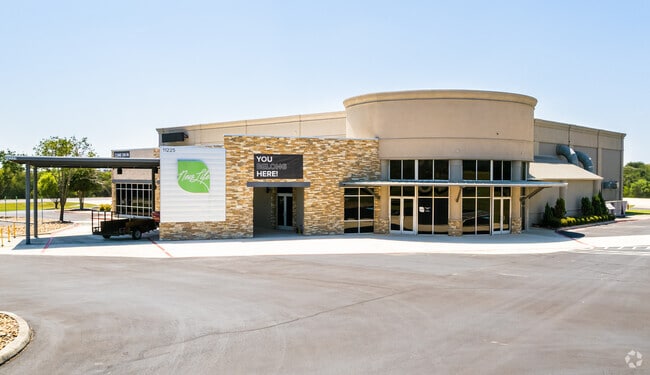

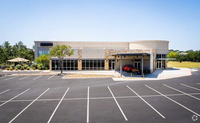
Property Detail
11225 E Loop 1604 N
San Antonio-New Braunfels, TX
CB 5053X BLK 1 LOT 2 APOSTOLIC UNIVERSAL CHURCH
05053-981-0020
BEXAR
Officebuilding
Texas
AE The base floodplain where base flood elevations are provided. AE Zones are now used on new format FIRMs instead of A1-A30 Zones.
2
0
18.20 AC
2025
Northeast
121604
San Antonio
22,136 SF
NEARBY LISTINGS FOR SALE OR LEASE
DEMOGRAPHICS near 11225 E Loop 1604 N
1 mile
3 mile
5 mile
2025 Total Population
8,715
86,831
223,268
2030 Population
9,093
91,761
238,117
Pop Growth 2025-2030
+ 4.34%
+ 5.68%
+ 6.65%
Average Age
36
38
38
2025 Total Households
3,071
31,807
79,431
HH Growth 2025-2030
+ 4.46%
+ 5.83%
+ 6.86%
Median Household Inc
$101,430
$79,667
$83,741
Avg Household Size
2.80
2.70
2.80
2025 Avg HH Vehicles
2.00
2.00
2.00
Median Home Value
$258,308
$248,645
$265,164
Median Year Built
2003
1992
1999
Nearby Places
Map Layers
Map Styles
 Street
 Aerial
Transit
 Traffic
 Biking
Places
Listings with unknown addresses are not visible on the map
- Restaurants
- Banks
- Shops
- Fitness
- Groceries
PUBLIC TRANSPORTATION
AIRPORT
San Antonio International
Drive
Walk
Distance
San Antonio International
20 min
12.1 mi
Freight Ports
Calhoun Port
Drive
Walk
Distance
Calhoun Port
175 min
144.9 mi
Nearby Properties
Address
Land Use
TOTAL SIZE
Lot Size
Zoning
Address
Land Use
TOTAL SIZE
Lot Size
Zoning
727,299 SF
47.68 AC
Address
Land Use
TOTAL SIZE
Lot Size
Zoning
116.47 AC
Address
Land Use
TOTAL SIZE
Lot Size
Zoning
347,943 SF
10.07 AC
Address
Land Use
TOTAL SIZE
Lot Size
Zoning
223,185 SF
16.85 AC
Address
Land Use
TOTAL SIZE
Lot Size
Zoning
242,267 SF
15.77 AC
Address
Land Use
TOTAL SIZE
Lot Size
Zoning
240,077 SF
16.92 AC
Address
Land Use
TOTAL SIZE
Lot Size
Zoning
218,379 SF
9.65 AC
Address
Land Use
TOTAL SIZE
Lot Size
Zoning
277,887 SF
14.14 AC
Address
Land Use
TOTAL SIZE
Lot Size
Zoning
251,707 SF
20.22 AC
Address
Land Use
TOTAL SIZE
Lot Size
Zoning
200,940 SF
10.31 AC
Address
Land Use
TOTAL SIZE
Lot Size
Zoning
245,993 SF
23.82 AC
Address
Land Use
TOTAL SIZE
Lot Size
Zoning
198,868 SF
15.15 AC
Address
Land Use
TOTAL SIZE
Lot Size
Zoning
271,018 SF
13.75 AC
Address
Land Use
TOTAL SIZE
Lot Size
Zoning
172,080 SF
17 AC
Address
Land Use
TOTAL SIZE
Lot Size
Zoning
190,134 SF
10.54 AC
Address
Land Use
TOTAL SIZE
Lot Size
Zoning
154,641 SF
9.07 AC
Address
Land Use
TOTAL SIZE
Lot Size
Zoning
156,381 SF
8.29 AC
Address
Land Use
TOTAL SIZE
Lot Size
Zoning
113,091 SF
12.60 AC
Address
Land Use
TOTAL SIZE
Lot Size
Zoning
190,717 SF
9.99 AC
Address
Land Use
TOTAL SIZE
Lot Size
Zoning
145,811 SF
10.36 AC
Address
Land Use
TOTAL SIZE
Lot Size
Zoning
183,611 SF
10.13 AC
Address
Land Use
TOTAL SIZE
Lot Size
Zoning
342,612 SF
28.49 AC
Address
Land Use
TOTAL SIZE
Lot Size
Zoning
97,924 SF
3.10 AC
Address
Land Use
TOTAL SIZE
Lot Size
Zoning
186,055 SF
17.44 AC
Address
Land Use
TOTAL SIZE
Lot Size
Zoning
205,469 SF
12.55 AC
Address
Land Use
TOTAL SIZE
Lot Size
Zoning
102,700 SF
4.68 AC
Address
Land Use
TOTAL SIZE
Lot Size
Zoning
124,690 SF
24.47 AC
Address
Land Use
TOTAL SIZE
Lot Size
Zoning
87,577 SF
10.27 AC
Address
Land Use
TOTAL SIZE
Lot Size
Zoning
67,168 SF
13.69 AC
Address
Land Use
TOTAL SIZE
Lot Size
Zoning
99,263 SF
13.69 AC
The World's #1 Commercial Real Estate Marketplace
Connect with us
© 2026 CoStar Group
The information above has been obtained from sources believed reliable. While we do not doubt its accuracy we have not verified it and make no guarantee, warranty or representation about it. It is your responsibility to independently confirm its accuracy and completeness. Any projections, opinions, assumptions, or estimates used are for example only and do not represent the current or future performance of the property. The value of this transaction to you depends on tax and other factors which should be evaluated by your tax, financial, and legal advisors. You and your advisors should conduct a careful, independent investigation of the property to determine to your satisfaction the suitability of the property for your needs.