Property Record
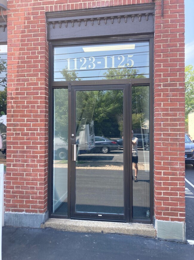
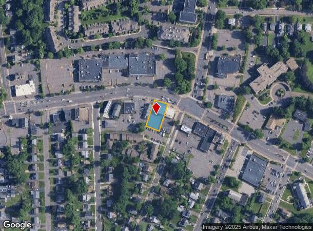
1123 New Britain Ave, West Hartford, CT 06110
Current Lease Availabilities
NEARBY LISTINGS FOR SALE OR LEASE
Property Detail
1123 New Britain Ave
WHAR-000014G-003771-001123
Hartford
Commercialbuilding
Connecticut
X
1123
09003C0501F
0.29 AC
2025
West Hartford
2025
Hartford
496200
Hartford-West Hartford-East Hartford, CT
5,300 SF
DEMOGRAPHICS near 1123 New Britain Ave
1 Mile
3 Mile
5 Mile
2024 Total Population
11,033
123,575
276,461
2029 Population
10,924
122,300
274,609
Pop Growth 2024-2029
(0.99%)
(1.03%)
(0.67%)
Average Age
40
40
39
2024 Total Households
4,506
50,145
111,162
HH Growth 2024-2029
(0.98%)
(1.06%)
(0.59%)
Median Household Inc
$81,715
$68,970
$64,477
Avg Household Size
2.40
2.30
2.30
2024 Avg HH Vehicles
2.00
2.00
1.00
Median Home Value
$249,493
$271,117
$270,178
Median Year Built
1954
1953
1956
Nearby Places
- Restaurants
- Banks
- Shops
- Fitness
- Groceries
PUBLIC TRANSPORTATION
COMMUTER RAIL
Hartford (Hartford Line - Hartford Line)
DRIVE
WALK
Distance
Hartford (Hartford Line - Hartford Line)
9 min
4.6 mi
Hartford Amtrak Station (Amtrak Hartford Line - Amtrak, Northeast Regional - Amtrak, Valley Flyer - Amtrak, Vermonter - Amtrak)
DRIVE
WALK
Distance
Hartford Amtrak Station (Amtrak Hartford Line - Amtrak, Northeast Regional - Amtrak, Valley Flyer - Amtrak, Vermonter - Amtrak)
10 min
4.8 mi
AIRPORT
Bradley International
DRIVE
WALK
Distance
Bradley International
41 min
22.2 mi
Freight Ports
Port of New Haven
DRIVE
WALK
Distance
Port of New Haven
50 min
34.9 mi
Nearby Properties
Address
Land Use
TOTAL SIZE
Lot Size
Zoning
Address
Land Use
TOTAL SIZE
Lot Size
Zoning
516,804 SF
32.98 AC
CAMP
Address
Land Use
TOTAL SIZE
Lot Size
Zoning
15.73 AC
CAMP
Address
Land Use
TOTAL SIZE
Lot Size
Zoning
284,432 SF
32.12 AC
PL
Address
Land Use
TOTAL SIZE
Lot Size
Zoning
261,072 SF
44.47 AC
PL
Address
Land Use
TOTAL SIZE
Lot Size
Zoning
3,605 SF
28.33 AC
R-6,RM
Address
Land Use
TOTAL SIZE
Lot Size
Zoning
20.61 AC
R-10,S
Address
Land Use
TOTAL SIZE
Lot Size
Zoning
416,762 SF
20 AC
CAMP
Address
Land Use
TOTAL SIZE
Lot Size
Zoning
20.41 AC
MX-2
Address
Land Use
TOTAL SIZE
Lot Size
Zoning
9,238 SF
28.35 AC
R-10,R
Address
Land Use
TOTAL SIZE
Lot Size
Zoning
23.62 AC
A3
Address
Land Use
TOTAL SIZE
Lot Size
Zoning
112,975 SF
11.44 AC
RM-3
Address
Land Use
TOTAL SIZE
Lot Size
Zoning
223,885 SF
43.33 AC
CAMP
Address
Land Use
TOTAL SIZE
Lot Size
Zoning
3,416 SF
19.31 AC
SRD
Address
Land Use
TOTAL SIZE
Lot Size
Zoning
3.41 AC
BC,RP
Address
Land Use
TOTAL SIZE
Lot Size
Zoning
86,600 SF
20.05 AC
R-6
Address
Land Use
TOTAL SIZE
Lot Size
Zoning
16.94 AC
C1
Address
Land Use
TOTAL SIZE
Lot Size
Zoning
126.75 AC
OS
Address
Land Use
TOTAL SIZE
Lot Size
Zoning
215,215 SF
42 AC
R-10,R
Address
Land Use
TOTAL SIZE
Lot Size
Zoning
171,729 SF
80.59 AC
R-12/
Address
Land Use
TOTAL SIZE
Lot Size
Zoning
2.32 AC
SDD/CB
Address
Land Use
TOTAL SIZE
Lot Size
Zoning
2.84 AC
CBDH
Address
Land Use
TOTAL SIZE
Lot Size
Zoning
8.87 AC
BS,R-1
Address
Land Use
TOTAL SIZE
Lot Size
Zoning
13.13 AC
SDD/BG
Address
Land Use
TOTAL SIZE
Lot Size
Zoning
638,979 SF
3.24 AC
MX-2
Address
Land Use
TOTAL SIZE
Lot Size
Zoning
215,058 SF
R-6
Address
Land Use
TOTAL SIZE
Lot Size
Zoning
Address
Land Use
TOTAL SIZE
Lot Size
Zoning
3.21 AC
MX-2
Address
Land Use
TOTAL SIZE
Lot Size
Zoning
111,532 SF
12.50 AC
R-12
Address
Land Use
TOTAL SIZE
Lot Size
Zoning
13.43 AC
SDD/BG
Address
Land Use
TOTAL SIZE
Lot Size
Zoning
141,200 SF
5.56 AC
MX-2
The World's #1 Commercial Real Estate Marketplace
Connect with us
© 2025 CoStar Group
The information above has been obtained from sources believed reliable. While we do not doubt its accuracy we have not verified it and make no guarantee, warranty or representation about it. It is your responsibility to independently confirm its accuracy and completeness. Any projections, opinions, assumptions, or estimates used are for example only and do not represent the current or future performance of the property. The value of this transaction to you depends on tax and other factors which should be evaluated by your tax, financial, and legal advisors. You and your advisors should conduct a careful, independent investigation of the property to determine to your satisfaction the suitability of the property for your needs.