Property Record
1121 Hackney St, Houston, TX 77023
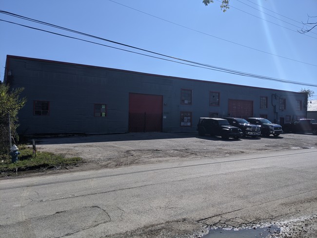

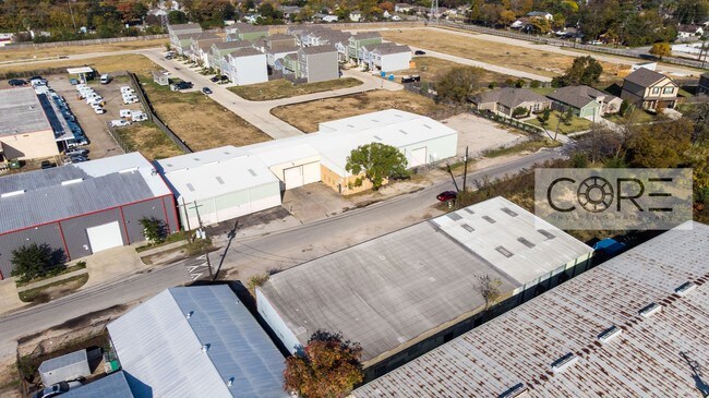
Property Detail
1121 Hackney St
Houston-Pasadena-The Woodlands, TX
LTS 6 THRU 10 BLK 2 LAWNDALE COURT
0630010020006
HARRIS
Warehouse
Texas
B and X Area of moderate flood hazard, usually the area between the limits of the 100-year and 500-year floods.
6-10
2024
0.57 AC
2025
Downtown Houston
310800
Houston
8,880 SF
NEARBY LISTINGS FOR SALE OR LEASE
DEMOGRAPHICS near 1121 Hackney St
1 mile
3 mile
5 mile
2024 Total Population
15,793
145,160
416,533
2029 Population
17,029
156,301
449,026
Pop Growth 2024-2029
+ 7.83%
+ 7.67%
+ 7.80%
Average Age
38
36
37
2024 Total Households
5,937
52,155
162,210
HH Growth 2024-2029
+ 7.98%
+ 8.47%
+ 8.57%
Median Household Inc
$49,935
$52,814
$60,723
Avg Household Size
2.60
2.50
2.30
2024 Avg HH Vehicles
2.00
2.00
2.00
Median Home Value
$348,980
$287,511
$268,968
Median Year Built
1953
1961
1972
Nearby Places
Map Layers
Map Styles
 Street
 Aerial
Transit
 Traffic
 Biking
Places
Listings with unknown addresses are not visible on the map
- Restaurants
- Banks
- Shops
- Fitness
- Groceries
PUBLIC TRANSPORTATION
AIRPORT
William P Hobby
Drive
Walk
Distance
William P Hobby
19 min
8.7 mi
George Bush Intcntl/Houston
Drive
Walk
Distance
George Bush Intcntl/Houston
33 min
22.1 mi
SALE & LEASE HISTORY
LISTING DATE
SALE/LEASE

Nov 15, 2019
For Lease
Jan 14, 2022
For Lease
Nearby Properties
Address
Land Use
TOTAL SIZE
Lot Size
Zoning
Address
Land Use
TOTAL SIZE
Lot Size
Zoning
1,091,726 SF
2.60 AC
Address
Land Use
TOTAL SIZE
Lot Size
Zoning
587,515 SF
4.85 AC
Address
Land Use
TOTAL SIZE
Lot Size
Zoning
453,987 SF
4.33 AC
Address
Land Use
TOTAL SIZE
Lot Size
Zoning
403,242 SF
46.18 AC
Address
Land Use
TOTAL SIZE
Lot Size
Zoning
400,641 SF
1.86 AC
Address
Land Use
TOTAL SIZE
Lot Size
Zoning
406,772 SF
4.30 AC
Address
Land Use
TOTAL SIZE
Lot Size
Zoning
1,171,276 SF
44.19 AC
Address
Land Use
TOTAL SIZE
Lot Size
Zoning
463,768 SF
6.23 AC
Address
Land Use
TOTAL SIZE
Lot Size
Zoning
278,362 SF
1.70 AC
Address
Land Use
TOTAL SIZE
Lot Size
Zoning
159,235 SF
1.49 AC
Address
Land Use
TOTAL SIZE
Lot Size
Zoning
406,586 SF
4.03 AC
Address
Land Use
TOTAL SIZE
Lot Size
Zoning
242,936 SF
Address
Land Use
TOTAL SIZE
Lot Size
Zoning
329,500 SF
1.82 AC
Address
Land Use
TOTAL SIZE
Lot Size
Zoning
310,171 SF
2.35 AC
Address
Land Use
TOTAL SIZE
Lot Size
Zoning
17.84 AC
Address
Land Use
TOTAL SIZE
Lot Size
Zoning
186,460 SF
1.45 AC
Address
Land Use
TOTAL SIZE
Lot Size
Zoning
245,307 SF
1.67 AC
Address
Land Use
TOTAL SIZE
Lot Size
Zoning
198,023 SF
17.87 AC
Address
Land Use
TOTAL SIZE
Lot Size
Zoning
33.97 AC
Address
Land Use
TOTAL SIZE
Lot Size
Zoning
901,984 SF
59.37 AC
Address
Land Use
TOTAL SIZE
Lot Size
Zoning
504,018 SF
37.16 AC
Address
Land Use
TOTAL SIZE
Lot Size
Zoning
419,760 SF
15.27 AC
Address
Land Use
TOTAL SIZE
Lot Size
Zoning
156,349 SF
1.44 AC
Address
Land Use
TOTAL SIZE
Lot Size
Zoning
923,370 SF
13.72 AC
Address
Land Use
TOTAL SIZE
Lot Size
Zoning
785,097 SF
27.77 AC
Address
Land Use
TOTAL SIZE
Lot Size
Zoning
148,444 SF
1.12 AC
Address
Land Use
TOTAL SIZE
Lot Size
Zoning
111,415 SF
0.93 AC
Address
Land Use
TOTAL SIZE
Lot Size
Zoning
985,528 SF
22.64 AC
Address
Land Use
TOTAL SIZE
Lot Size
Zoning
923,370 SF
13.76 AC
Address
Land Use
TOTAL SIZE
Lot Size
Zoning
232,915 SF
7.89 AC
The World's #1 Commercial Real Estate Marketplace
Connect with us
© 2026 CoStar Group
The information above has been obtained from sources believed reliable. While we do not doubt its accuracy we have not verified it and make no guarantee, warranty or representation about it. It is your responsibility to independently confirm its accuracy and completeness. Any projections, opinions, assumptions, or estimates used are for example only and do not represent the current or future performance of the property. The value of this transaction to you depends on tax and other factors which should be evaluated by your tax, financial, and legal advisors. You and your advisors should conduct a careful, independent investigation of the property to determine to your satisfaction the suitability of the property for your needs.