Property Record
11210 Us 15 501 Hwy, Aberdeen, NC 28315
NEARBY LISTINGS FOR SALE OR LEASE
Property Detail
11210 Us 15 501 Hwy
Pinehurst-Southern Pines, NC
Aberdeen Place Llc
8571-18-40-9934
LOT 1
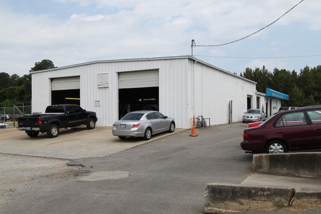
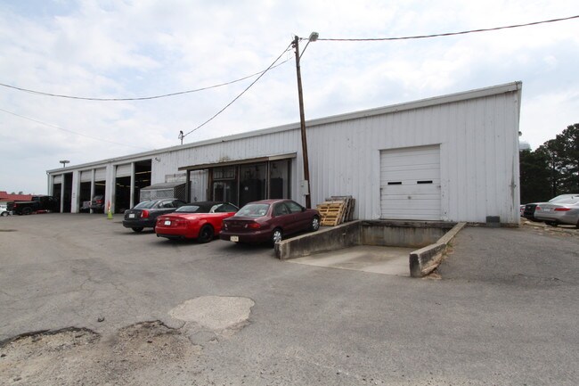
Autorepair
Moore
X
North Carolina
3710857100J
1
2024
5 AC
2024
North Carolina Southeast Area
951102
Other Market Areas
2,350 SF
DEMOGRAPHICS near 11210 Us 15 501 Hwy
1 Mile
3 Mile
5 Mile
2024 Total Population
5,034
26,298
49,654
2029 Population
5,772
30,441
57,445
Pop Growth 2024-2029
+ 14.66%
+ 15.75%
+ 15.69%
Average Age
39
42
44
2024 Total Households
2,280
11,857
22,206
HH Growth 2024-2029
+ 14.91%
+ 16.01%
+ 15.96%
Median Household Inc
$51,972
$66,363
$71,553
Avg Household Size
2.10
2.10
2.20
2024 Avg HH Vehicles
2.00
2.00
2.00
Median Home Value
$305,410
$345,258
$344,387
Median Year Built
1997
1994
1994
Nearby Places
Map Layers
Map Styles
 Street
 Aerial
- Restaurants
- Banks
- Shops
- Fitness
- Groceries
PUBLIC TRANSPORTATION
COMMUTER RAIL
Southern Pines Amtrak Station (Silver Star - Amtrak)
DRIVE
WALK
Distance
Southern Pines Amtrak Station (Silver Star - Amtrak)
5 min
2.5 mi
Freight Ports
Port of Wilmington
DRIVE
WALK
Distance
Port of Wilmington
166 min
132.6 mi
SALE & LEASE HISTORY
LISTING DATE
SALE/LEASE

Sep 23, 2016
For Sale
May 10, 2019
For Sale
Mar 30, 2017
For Sale
Mar 23, 2017
For Sale
Feb 02, 2017
For Sale
Apr 20, 2017
For Sale
Apr 04, 2018
For Sale
Nearby Properties
Address
Land Use
TOTAL SIZE
Lot Size
Zoning
Address
Land Use
TOTAL SIZE
Lot Size
Zoning
20,091 SF
12 AC
PPC
Address
Land Use
TOTAL SIZE
Lot Size
Zoning
18.49 AC
Address
Land Use
TOTAL SIZE
Lot Size
Zoning
16.26 AC
PD
Address
Land Use
TOTAL SIZE
Lot Size
Zoning
7,024 SF
9.05 AC
Address
Land Use
TOTAL SIZE
Lot Size
Zoning
26.75 AC
Address
Land Use
TOTAL SIZE
Lot Size
Zoning
Address
Land Use
TOTAL SIZE
Lot Size
Zoning
21,138 SF
473.33 AC
RD
Address
Land Use
TOTAL SIZE
Lot Size
Zoning
70,130 SF
19.18 AC
Address
Land Use
TOTAL SIZE
Lot Size
Zoning
22,772 SF
12.46 AC
HC
Address
Land Use
TOTAL SIZE
Lot Size
Zoning
51,552 SF
33.02 AC
GBCD
Address
Land Use
TOTAL SIZE
Lot Size
Zoning
4,184 SF
13.85 AC
R6
Address
Land Use
TOTAL SIZE
Lot Size
Zoning
83,896 SF
66.98 AC
R20
Address
Land Use
TOTAL SIZE
Lot Size
Zoning
44.59 AC
MULTI
Address
Land Use
TOTAL SIZE
Lot Size
Zoning
4,992 SF
14.75 AC
PD
Address
Land Use
TOTAL SIZE
Lot Size
Zoning
12.78 AC
Address
Land Use
TOTAL SIZE
Lot Size
Zoning
Address
Land Use
TOTAL SIZE
Lot Size
Zoning
39,490 SF
5.16 AC
GBCD
Address
Land Use
TOTAL SIZE
Lot Size
Zoning
4,710 SF
6.95 AC
R6
Address
Land Use
TOTAL SIZE
Lot Size
Zoning
Address
Land Use
TOTAL SIZE
Lot Size
Zoning
199,100 SF
24.89 AC
HC
Address
Land Use
TOTAL SIZE
Lot Size
Zoning
8.15 AC
GC
Address
Land Use
TOTAL SIZE
Lot Size
Zoning
Address
Land Use
TOTAL SIZE
Lot Size
Zoning
7.62 AC
Address
Land Use
TOTAL SIZE
Lot Size
Zoning
33,296 SF
11.23 AC
HC
Address
Land Use
TOTAL SIZE
Lot Size
Zoning
2,450 SF
2.96 AC
Address
Land Use
TOTAL SIZE
Lot Size
Zoning
57,109 SF
4.08 AC
GBSD
Address
Land Use
TOTAL SIZE
Lot Size
Zoning
0.84 AC
GC
Address
Land Use
TOTAL SIZE
Lot Size
Zoning
Address
Land Use
TOTAL SIZE
Lot Size
Zoning
9,690 SF
19.96 AC
HC
Address
Land Use
TOTAL SIZE
Lot Size
Zoning
47,273 SF
11.25 AC
NC
The World's #1 Commercial Real Estate Marketplace
Connect with us
© 2025 CoStar Group
The information above has been obtained from sources believed reliable. While we do not doubt its accuracy we have not verified it and make no guarantee, warranty or representation about it. It is your responsibility to independently confirm its accuracy and completeness. Any projections, opinions, assumptions, or estimates used are for example only and do not represent the current or future performance of the property. The value of this transaction to you depends on tax and other factors which should be evaluated by your tax, financial, and legal advisors. You and your advisors should conduct a careful, independent investigation of the property to determine to your satisfaction the suitability of the property for your needs.